- Clayhanger, Devon
-
Coordinates: 50°59′54″N 3°23′43″W / 50.998245°N 3.3951395°W
Clayhanger 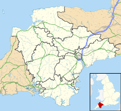
 Clayhanger
Clayhanger shown within DevonOS grid reference ST0219523021 District Mid Devon Shire county Devon Region South West Country England Sovereign state United Kingdom Post town TIVERTON Postcode district EX16 7N Police Devon and Cornwall Fire Devon and Somerset Ambulance South Western EU Parliament South West England UK Parliament Tiverton and Honiton List of places: UK • England • Devon Clayhanger is a hamlet in the Mid Devon district of Devon, England. It is close to the site of a Roman fort east of the Upper Exe Valley (Cudmore Farm).
Towns, villages and hamlets in the Mid Devon District of Devon, England 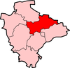 Ashill · Bampton · Bickleigh · Blackborough · Butterleigh · Cadbury · Clayhanger · Colebrooke · Cove · Crediton · Cullompton · Exebridge · Huntsham · Kentisbeare · Morebath · Oakford · Shillingford · Stoodleigh · Tiverton · WillandCategories:
- Roman forts in Devon
- Hamlets in Devon
- Devon geography stubs


Wikimedia Foundation. 2010.