- Cove, Devon
-
Coordinates: 50°57′58″N 3°29′43″W / 50.966210°N 3.4954099°W
Cove 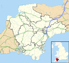
 Cove
Cove
Cove shown within DevonOS grid reference SS9508719597 Parish Cove District Mid Devon Shire county Devon Region South West Country England Sovereign state United Kingdom Post town TIVERTON Postcode district EX16 7 Dialling code 01398 Police Devon and Cornwall Fire Devon and Somerset Ambulance South Western EU Parliament South West England UK Parliament Tiverton and Honiton List of places: UK • England • Devon Cove is a small village and civil parish in the county of Devon, England. It is situated 4 miles north of Tiverton and 2 miles from Bampton in the Exe Valley some 450 feet above sea level. Cove was formed into an ecclesiastical parish in 1886. The church of St. John the Baptist, erected in 1846 on the site of an earlier building, is an edifice of stone in the plain Gothic style consisting of chancel, nave and vestry. Services ceased in 1987 and the building is now a private residence. The register dates from the years 1680 to 1987. The exe valley railway used to run through the village and you can still see the old station house and platform which is currently lived in.
The manor of Cove was acquired in 1763 by Robert Row of Livingshayes, Silverton, from Thomas Carew of Crowcombe, Somerset. Cove House, erected in 1800, is a pillared Bath stone mansion, standing on an elevated plateau, surrounded by park land and woodland with panoramic views of the valley.The Cove Estate, along with the fishing rights, was sold in 1922 by the North-Row family and gave the opportunity for many tenants to acquire the freehold of their properties.
Towns, villages and hamlets in the Mid Devon District of Devon, England  Ashill · Bampton · Bickleigh · Blackborough · Butterleigh · Cadbury · Clayhanger · Colebrooke · Cove · Crediton · Cullompton · Exebridge · Huntsham · Kentisbeare · Morebath · Oakford · Shillingford · Stoodleigh · Tiverton · WillandCategories:
- Devon geography stubs
- Villages in Devon


Wikimedia Foundation. 2010.