- Crowcombe
-
Coordinates: 51°07′26″N 3°13′38″W / 51.1240°N 3.2273°W
Crowcombe 
Crowcombe Church
 Crowcombe
Crowcombe shown within SomersetPopulation 500 [1] OS grid reference ST142368 District Taunton Deane Shire county Somerset Region South West Country England Sovereign state United Kingdom Postcode district TA4 Police Avon and Somerset Fire Devon and Somerset Ambulance South Western EU Parliament South West England UK Parliament Bridgwater and West Somerset List of places: UK • England • Somerset Crowcombe is a village and civil parish under the Quantock Hills in Somerset, England, 5.5 miles (9 km) south east of Watchet, and 8 miles (13 km) from Taunton in the Taunton Deane district. The village has a population of 500.[1]
The parish covers the hamlets of Crowcombe Heathfield, Flaxpool, Halsway, Lawford and Triscombe.[2]
Contents
History
The name Triscombe is believed to derive from the Old English words treows and cumb.[3]
The first documentary evidence of the village is by Æthelwulf of Wessex in 854, where it was spelt 'Cerawicombe'.[4] At that time the manor belonged to Glastonbury Abbey.[5] Later Gytha Thorkelsdóttir, wife of Earl Godwin, gifted it to the monks of Winchester to make amends for her husband's "treacherous abuses of divers monastic institutions".[6]
The Domesday Book of 1086 lists the village as 'Crawcombe', which is believed to come from the Old English words craw and cumb.[7] The parish of Crowcombe was part of the Williton and Freemanners Hundred.[8]
Crowcombe Heathfield railway station is two miles from the village on the West Somerset Railway, a heritage railway.
Governance
The parish council has responsibility for local issues, including setting an annual precept (local rate) to cover the council’s operating costs and producing annual accounts for public scrutiny. The parish council evaluates local planning applications and works with the local police, district council officers, and neighbourhood watch groups on matters of crime, security, and traffic. The parish council's role also includes initiating projects for the maintenance and repair of parish facilities, as well as consulting with the district council on the maintenance, repair, and improvement of highways, drainage, footpaths, public transport, and street cleaning. Conservation matters (including trees and listed buildings) and environmental issues are also the responsibility of the council.
The village falls within the Non-metropolitan district of West Somerset, which was formed on April 1, 1974 under the Local Government Act 1972, having previously been part of Williton Rural District.[9] The district council is responsible for local planning and building control, local roads, council housing, environmental health, markets and fairs, refuse collection and recycling, cemeteries and crematoria, leisure services, parks, and tourism.
Somerset County Council is responsible for running the largest and most expensive local services such as education, social services, libraries, main roads, public transport, policing and fire services, trading standards, waste disposal and strategic planning.
It is also part of the Bridgwater and West Somerset county constituency represented in the House of Commons of the Parliament of the United Kingdom. It elects one Member of Parliament (MP) by the first past the post system of election, and part of the South West England constituency of the European Parliament which elects seven MEPs using the d'Hondt method of party-list proportional representation.
Geography
It is the central point on the Quantock Greenway a footpath exploring the Quantock Hills.
Roebuck Meadows is a biological Site of Special Scientific Interest for their very varied and herb-rich vegetation composed of mire and grassland communities together comprising an important example of lowland mire, which is a nationally scarce habitat. The meadows contain Cornish Moneywort (Sibthorpia europaea), a nationally scarce plant restricted to south west Britain.[10]
Landmarks
Crowcombe Court
Crowcombe Court is a large country house dating from 1724–39, by Thomas Parker and finished by Nathaniel Ireson of Wincanton. Minor alterations were carried out by Edward Middleton Barry around 1870. It is Grade I listed.[11] It has previously been used as a nursing home and today the Court is hired out for weddings and other functions.[2]
Halsway Manor
Halsway Manor is England's National Centre for Traditional Music, Dance and Song. It is the only residential folk centre in the UK. The eastern end of the building dates from fifteen century with the western end as an addition in the nineteenth century.[12]
Religious sites
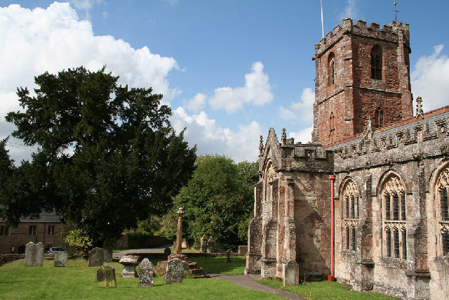
The Church of the Holy Ghost has a tower dating from the 14th century with the rest of the building being dated at the 15th century. It has been designated by English Heritage as a Grade I listed building.[13]
In 1724 the spire was damaged by a lightning strike.[14] The top section of the spire was removed and is now planted in the churchyard[14] and stone from the spire was used in the flooring of the church. Inside the church carved bench-ends, dating from 1534,[15] depict such pagan subjects as the Green Man and the legend of the men of Crowcombe fighting a two-headed dragon.[16]
Church House
The Church House and Pound was built around 1515 for parish functions, later being used to house the poor of the village on the lower floor and a school on the upper. Following an appeal for public funds to repair the building in 1907,[17] the ground floor is now being used as a village hall and the upper to house exhibitions.[16] It is a Grade II* listed building.[18] Further grants and public fund raising in 2007 enabled a major refurbishment.[19]
References
- ^ a b "Crowcombe". Crowcombe. http://www.crowcombe.org.uk/index.htm. Retrieved 2007-11-17.
- ^ a b "Crowcombe". Quantock Online. http://www.quantockonline.co.uk/quantocks/villages/crowcombe/crowcombe1.html. Retrieved 2007-11-17.
- ^ Robinson, Stephen (1992). Somerset Place Names. Dovecote Press. ISBN 1874336032.
- ^ "Crowcombe". Whats on Exmoor. http://www.whatsonexmoor.co.uk/villages/crowcombe.htm. Retrieved 2007-11-17.
- ^ "Crowcombe by Clare Gathercole". Somerset Urban Archaeological Survey. http://www1.somerset.gov.uk/archives/hes/downloads/EUS_CrowcombeText.pdf. Retrieved 2010-02-02.
- ^ Waite, Vincent (1964). Portrait of the Quantocks. London: Robert Hale. ISBN 0709111584.
- ^ Robinson, Stephen (1992). Somerset Place Names. Dovecote Press. ISBN 1874336032.
- ^ "Somerset Hundreds". GENUKI. http://www.genuki.org.uk/big/eng/SOM/Miscellaneous/. Retrieved 23 October 2011.
- ^ A Vision of Britain Through Time : Williton Rural District
- ^ "Roebuck Meadows". English Nature. http://www.english-nature.org.uk/citation/citation_photo/1003204.pdf. Retrieved 2006-08-19.
- ^ "Crowcombe Court and attached stables to west". Images of England. http://www.imagesofengland.org.uk/details/default.aspx?id=265103. Retrieved 2007-11-17.
- ^ "History of the Manor". Halsway Manor. Archived from the original on 2007-11-06. http://web.archive.org/web/20071106103754/http://halswaymanor.co.uk/manor/manor.html. Retrieved 2007-11-17.
- ^ "Church House and Pound". Images of England. http://www.imagesofengland.org.uk/details/default.aspx?id=265100. Retrieved 2007-11-17.
- ^ a b "Remains of spire, in churchyard, 15 metres east of chancel, Church of the Holy Ghost". Images of England. http://www.imagesofengland.org.uk/details/default.aspx?id=265089. Retrieved 2007-11-17.
- ^ "Crowcombe". Everything Exmoor. http://www.secretpeople.co.uk/_C/Crowcombe.php. Retrieved 2007-11-17.
- ^ a b "History". Crowcombe. http://www.crowcombe.org.uk/history.htm. Retrieved 2007-11-17.
- ^ "History". Church House Crowcombe. http://www.churchhousecrowcombe.org.uk/history.php. Retrieved 2007-11-17.
- ^ "Church of the Holy Ghost". Images of England. http://www.imagesofengland.org.uk/details/default.aspx?id=265086. Retrieved 2007-11-17.
- ^ "Crowcombe Chuirch House". Somerset Rural Renaissance. http://www.somerset-rural-renaissance.co.uk/projects-crowcombe-church-upgrade.html. Retrieved 14 May 2010.
External links
Towns, villages and hamlets in the West Somerset district of Somerset, England 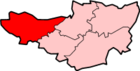 Allerford · Ashbeer · Bicknoller · Brandish Street · Brompton Ralph · Brompton Regis · Brushford · Carhampton · Clatworthy · Cockercombe · Crowcombe · Culbone · Cutcombe · Dulverton · Dunster · East Quantoxhead · Elworthy · Exford · Exton · Holford · Huish Champflower · Kilve · Lilstock · Luccombe · Luxborough · Minehead · Monksilver · Oare · Old Cleeve · Porlock · Roadwater · Sampford Brett · Selworthy · Simonsbath · Skilgate · Stogumber · Stogursey · Stringston · Timberscombe · Treborough · Upton · Washford · Watchet · West Quantoxhead · Williton · Winsford · Withycombe · Withypool · Wootton CourtenayCategories:
- Villages in Taunton Deane
- Civil parishes in Somerset


Wikimedia Foundation. 2010.