- Dunster
-
Coordinates: 51°10′57″N 3°26′45″W / 51.1825°N 3.4459°W
Dunster 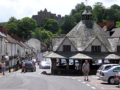
Dunster Yarn Market
 Dunster
Dunster shown within SomersetPopulation 862 [1] OS grid reference SS990436 District West Somerset Shire county Somerset Region South West Country England Sovereign state United Kingdom Post town MINEHEAD Postcode district TA24 Dialling code 01643 Police Avon and Somerset Fire Devon and Somerset Ambulance South Western EU Parliament South West England UK Parliament Bridgwater and West Somerset List of places: UK • England • Somerset Dunster is a village and civil parish in west Somerset, England, situated on the Bristol Channel coast 2.5 miles (4.0 km) south-southeast of Minehead and 20 miles (32.2 km) northwest of Taunton. The village has a population of 862 (2001).[1]
The village has numerous restaurants and three pubs. West Street is the oldest street; though a quieter street than the high street it has three specialist shops: a Christmas shop, a kitchenware shop, and a gift shop. At the end of West Street is Dunster Working Watermill.
Dunster was listed in the Domesday Book of 1086 as Torre, meaning 'The rocky hill' from the Old English tor. The prefix 'Duns' may well be a reference to the Saxon Dunn, who held land in nearby Elworthy and Willet before 1066.[2]
Dunster Beach, which includes the mouth of the River Avill, is located half a mile from the village, and used to have a significant harbour, known as Dunster Haven, which was used for the export of wool from Saxon times;[3] however, it was last used in the 17th century and has now disappeared among the dykes, meadows and marshes near the shore.[4] The beach site has a number of privately owned beach huts (or chalets as some owners call them) along with a small shop, a tennis court and a putting green. The chalets, measuring 18 by 14 feet (5.5 by 4.3 m), can be let out for holidays; some owners live in them all the year round.[5]
Contents
History
Just southwest of Dunster are Bat's Castle and Black Ball Camp on Gallox Hill (also known as British Camp). They were Iron Age hill forts.[6][7] There was a similar earthwork on Grabbist Hill.[8]
Dunster is mentioned not only as a manor belonging to William de Moyon in the Domesday Book in 1086 but also the site of his castle.[9]
The 15th-century Gallox Bridge was one of the main routes over the River Avill on the southern outskirts.[10]
Dunster was part of the hundred of Carhampton.[11]
During the English Civil War, Dunster was initially held as a garrison for the Royalists.[12] It fell to the Parliamentarians in 1645 and orders were sent out for the castle to be demolished.[12] However, these were not carried out, and the castle remained the garrison for Parliamentarian troops until 1650.
Dunster is regularly home to Taunton Garrison who re-enact plays, battles, and life in the civil war.
Dunster was the birthplace of the song All Things Bright and Beautiful when Cecil Alexander was staying with Mary Martin. The nearby hill, Grabbist, was originally heather-covered before tree plantation and was described as the "Purple headed mountain".[13] Mary Martin was daughter of one of the owners of Martins Bank.
During the Second World War, considerable defences were built along the coast as a part of British anti-invasion preparations, though the north coast of Somerset was an unlikely invasion site.[14] Some of the structures remain to this day. Most notable are the pillboxes on the foreshore of Dunster Beach.[15] These are strong buildings made from pebbles taken from the beach and bonded together with concrete. From these, soldiers could have held their ground if the Germans ever invaded.
Governance
The parish council has responsibility for local issues, including setting an annual precept (local rate) to cover the council’s operating costs and producing annual accounts for public scrutiny. The parish council evaluates local planning applications and works with the local police, district council officers, and neighbourhood watch groups on matters of crime, security, and traffic. The parish council's role also includes initiating projects for the maintenance and repair of parish facilities, as well as consulting with the district council on the maintenance, repair, and improvement of highways, drainage, footpaths, public transport, and street cleaning. Conservation matters (including trees and listed buildings) and environmental issues are also the responsibility of the council.
The village falls within the Non-metropolitan district of West Somerset, which was formed on 1 April 1974 under the Local Government Act 1972; previously it was part of Williton Rural District.[16] The district council is responsible for local planning and building control, local roads, council housing, environmental health, markets and fairs, refuse collection and recycling, cemeteries and crematoria, leisure services, parks, and tourism.
Somerset County Council is responsible for running the largest and most expensive local services such as education, social services, libraries, main roads, public transport, policing and fire services, trading standards, waste disposal and strategic planning.
As Dunster falls within the Exmoor National Park, some functions normally administered by district or county councils have, since 1997, fallen under the Exmoor National Park Authority, which is known as a 'single-purpose' authority, whose purpose is to "conserve and enhance the natural beauty, wildlife and cultural heritage of the National Parks" and "promote opportunities for the understanding and enjoyment of the special qualities of the Parks by the public",[17] including responsibility for the conservation of the historic environment.[18]
It is also part of the Bridgwater and West Somerset county constituency represented in the House of Commons of the Parliament of the United Kingdom. It elects one Member of Parliament (MP) by the first past the post system of election, and is part of the South West England constituency of the European Parliament; the constituency elects seven MEPs using the d'Hondt method of party-list proportional representation.
Geography
Nearby is the Dunster Park and Heathlands Site of Special Scientific Interest noted for nationally important lowland dry heath, dry lowland acid grassland, wood-pasture with veteran trees and ancient semi-natural oak woodland habitats. The fauna of the lowland heath includes the Heath fritillary (Mellicta athalia), a nationally rare butterfly. The assemblage of beetles associated with the veteran trees is of national significance.[19]
Landmarks
Dunster, in Exmoor National Park, has many listed buildings including 200 Grade II, two Grade I and two Grade I*.
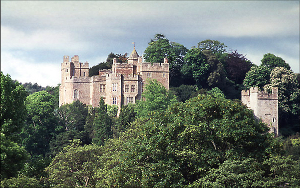
Dunster Castle is situated on a steep hill overlooking the village. Of the Norman castle, sited on what is now the keep, little remains except for the 13th-century gatehouse. The present building was developed in 1617 with subsequent refurbishment in the 1680s including fine plasterwork ceilings and the main staircase. The castle was largely remodelled in the Victorian period by Anthony Salvin. Salvin added towers and turrets giving the castle its fairy-tale appearance. The castle came into the possession of the Luttrell family in the late 14th century and remained in their ownership until it was given to the National Trust in 1976. It has been designated by English Heritage as a Grade I listed building.[20]
The 17th-century Yarn Market (1609) was an important centre for the dominant wool trade.[21] The building contains a hole in one of the roof beams, a result of cannon fire in the Civil War.
 St George's church, Dunster
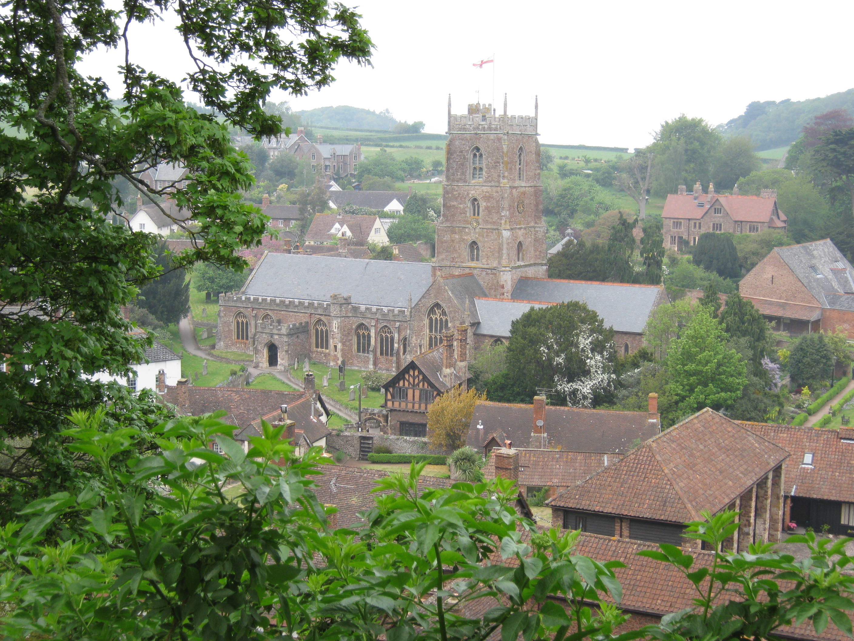
The Priory Church of St George[22] is predominantly 15th century with evidence of 12th and 13th century work. It was restored in 1875–77 by George Edmund Street. The church has a cruciform plan with a central four-stage tower, built in 1443 with diagonal buttresses, a stair turret and single bell-chamber windows.[23]
Other notable buildings include the Nunnery, Dunster Mill, Dovecote and the Priory barn, which belonged to Dunster Priory.
The Luttrell Arms was formerly a guest house for the Abbots of Cleeve; its oldest section dates from 1443.[24] The hotel now has 28 ensuite rooms.
Conygar Tower is a folly used as a landmark for shipping. It is situated on the top of Conygar Hill and overlooks the village. It was designed and built by Richard Phelps in 1776 and was commissioned by Henry Fownes Luttrell.[25] It has no strategic or military significance.
Other attractions include a Doll Museum.
Transport
Dunster railway station is on the West Somerset Heritage Railway, though the station is over a mile from the village. It is in what is known locally as the Marsh.
Culture
On the evening of 1 May each year the Minehead Hobby Horse visits Dunster and is received at the Castle. A local newspaper printed in May 1863 says "The origin professes to be in commemoration of the wreck of a vessel at Minehead in remote times, or the advent of a sort of phantom ship which entered the harbour without Captain or crew. Once the custom was encouraged, but now is much neglected, and perhaps soon will fall into desuetude." Another conjecture about its origin is that the hobby horse was the ancient King of the May. The Hobby Horse tradition begins with the waking of the inhabitants of Minehead by the beating of a loud drum. The hobby horse dances its way about the town and on to Dunster Castle. The Sailors' horse with drummers and a squeeze box or accordion playing traditional tunes. From Dunster it returns to Minehead, collecting donations on the way and searching out money in the pubs; originally the custom was to sneak into houses, supposedly leaving good luck behind it.
A more recent tradition (started in 1987) is Dunster by Candlelight which takes place every year on the first Friday and Saturday in December when this remarkably preserved medieval village turns its back on the present and lights its streets with candles.
To mark the beginning of the festival on Friday at 5 pm, there is the Lantern Lighting Procession that starts on the Steep and continues through the village until all the lanterns in the streets have been lit. The procession of children and their families is accompanied by colourful stilt walkers in costumes who put up the lanterns.
The old English Christmas tradition of burning the Ashen faggot takes place at the Luttrell Arms hotel every Christmas Eve.
References
- ^ a b "Parish Population Statistics". ONS Census 2001. Somerset County Council. http://www.webcitation.org/5lRyCc5hq. Retrieved 3 July 2008.
- ^ Robinson, Stephen (1992). Somerset Place Names. Wimborne, Dorset: The Dovecote Press. ISBN 1874336032.
- ^ Gathercole, Clare. "Dunster". Somerset Urban Archaeological Survey. Somerset County Council. http://www1.somerset.gov.uk/archives/hes/downloads/EUS_DunsterText.pdf. Retrieved 2 February 2010.
- ^ Farr, Grahame (1954). Somerset Harbours. London: Christopher Johnson. pp. 138–140.
- ^ The history of Dunster Beach" by Bernard Concannon,Monkspath Books, 1995 (ISBN 0-9526884-0-9)
- ^ Adkins, Lesley and Roy (1992). A Field Guide to Somerset Archaeology. Wimborne, Dorset: The Dovecote Press. ISBN 0946159947.
- ^ "Black Ball Camp". Arts and Humanities Data Service (AHDS). http://ads.ahds.ac.uk/catalogue/search/fr.cfm?rcn=NMR_NATINV-36857. Retrieved 28 September 2007.
- ^ "univallate hillfort". Arts and Humanities Data Service (AHDS). http://ads.ahds.ac.uk/catalogue/search/fr.cfm?rcn=NMR_NATINV-36851. Retrieved 28 September 2007.
- ^ Domesday Book: A Complete Translation. London: Penguin, 2003. ISBN 0-14-143994-7 p.263
- ^ "Gallox Bridge". Pastscape. English Heritage. http://pastscape.english-heritage.org.uk/hob.aspx?hob_id=36854. Retrieved 13 April 2009.
- ^ "Carhampton Hundred". Domesday Map. http://www.domesdaymap.co.uk/hundred/carhampton/. Retrieved 23 September 2011.
- ^ a b "The Civil War in Somerset". Somerset County Council. http://www.somerset.gov.uk/archives/ASH/Civilwar.htm. Retrieved 13 June 2009.
- ^ "Avill Valley". Everything Exmoor. http://everythingexmoor.org.uk/page.php?id=51. Retrieved 13 June 2009.
- ^ Foot, William (2006). Beaches, fields, streets, and hills ... the anti-invasion landscapes of England, 1940. Council for British Archaeology. pp. 95–101. ISBN 1-902771-53-2.
- ^ Pillbox
- ^ A Vision of Britain Through Time : Williton Rural District
- ^ "The Authority". Exmoor National Park. http://www.exmoor-nationalpark.gov.uk/index/living_in/the_authority.htm. Retrieved 29 November 2007.
- ^ "Exmoor National Park NMP". English Heritage. http://www.english-heritage.org.uk/server/show/nav.00100200300400200300l. Retrieved 29 November 2007.
- ^ "Dunster Park and Heathlands". English Nature. http://www.english-nature.org.uk/citation/citation_photo/2000415.pdf. Retrieved 12 August 2006.
- ^ "Dunster Castle and gatehouse". Images of England. http://www.imagesofengland.org.uk/details/default.aspx?id=264651. Retrieved 28 September 2007.
- ^ "Yarn Market". Images of England. http://www.imagesofengland.org.uk/details/default.aspx?id=264694. Retrieved 28 September 2007.
- ^ "Priory Church of St George". Images of England. http://www.imagesofengland.org.uk/details/default.aspx?id=264660. Retrieved 28 September 2007.
- ^ "Priory Church of St George, Dunster". Images of England. http://www.imagesofengland.org.uk/Details/Default.aspx?id=264660. Retrieved 6 March 2008.
- ^ "The Luttrell Arms Hotel". Images of England. http://www.imagesofengland.org.uk/details/default.aspx?id=264681. Retrieved 28 September 2007.
- ^ "Conygar Tower". Images of England. http://www.imagesofengland.org.uk/details/default.aspx?id=264747. Retrieved 28 September 2007.
External links
- Dunster at the Open Directory Project
- Benedictine Priory of Dunster, A History of the County of Somerset: Vol 2 (1911)
Towns, villages and hamlets in the West Somerset district of Somerset, England 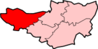 Allerford · Ashbeer · Bicknoller · Brandish Street · Brompton Ralph · Brompton Regis · Brushford · Carhampton · Clatworthy · Cockercombe · Crowcombe · Culbone · Cutcombe · Dulverton · Dunster · East Quantoxhead · Elworthy · Exford · Exton · Holford · Huish Champflower · Kilve · Lilstock · Luccombe · Luxborough · Minehead · Monksilver · Oare · Old Cleeve · Porlock · Roadwater · Sampford Brett · Selworthy · Simonsbath · Skilgate · Stogumber · Stogursey · Stringston · Timberscombe · Treborough · Upton · Washford · Watchet · West Quantoxhead · Williton · Winsford · Withycombe · Withypool · Wootton CourtenayCategories:
- Exmoor
- Villages in West Somerset
- Ports and harbours of Somerset
- Civil parishes in Somerset


Wikimedia Foundation. 2010.