- Dunster Dovecote
-
Dovecote 
Location: Dunster, Somerset, England Coordinates: 51°11′01″N 3°26′46″W / 51.18361°N 3.44611°WCoordinates: 51°11′01″N 3°26′46″W / 51.18361°N 3.44611°W Built: 16th century Built for: Priory of Dunster Listed Building – Grade II* Designated: 22 May, 1969[1] Reference #: 264714 Scheduled monument Designated: 4 August, 1983[2] Reference #: Somerset County No 33 
 Location of Dovecote in Somerset
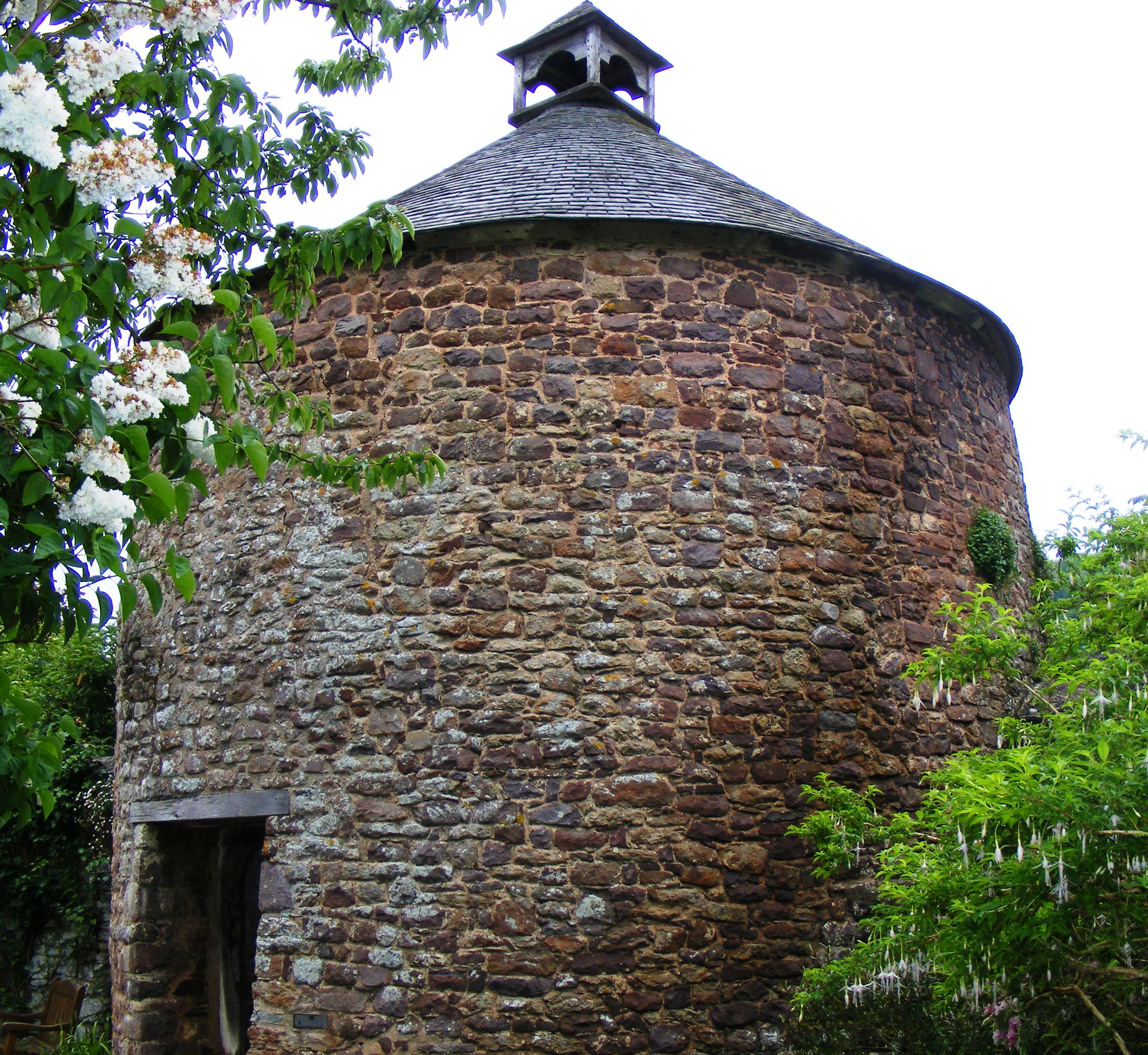
The Dovecote in Dunster, Somerset, England was probably built in the late 16th century. It has been designated as a Grade II* listed building and Scheduled Ancient Monument.[1]
It is situated on Priory Green opposite the Tithe Barn and close to the walls of the Priory Church of St George. It is approximately 19 feet (5.8 m) high and 19 feet (5.8 m) in diameter,[3] with walls around 4 feet (1.2 m) thick.[4] There are five hundred and forty nest-holes.[3]
There is no documentary evidence for the dovecote's date of construction but it some of the architectural features suggest it may have been as long ago as the 14th century. It would originally have belonged to the Benedictine Priory of Dunster which was a cell of Bath Abbey. Domestic Pigeons were kept to provide Squabs a luxury food from the breast meat of young pigeons. Form the 12th century until 1619, only Lords of the Manor and parish priest were allowed to keep them. The priory was abolished in the dissolution of the monasteries in 1539, and property belonging to it was sold to the Luttrell family of Dunster Castle.
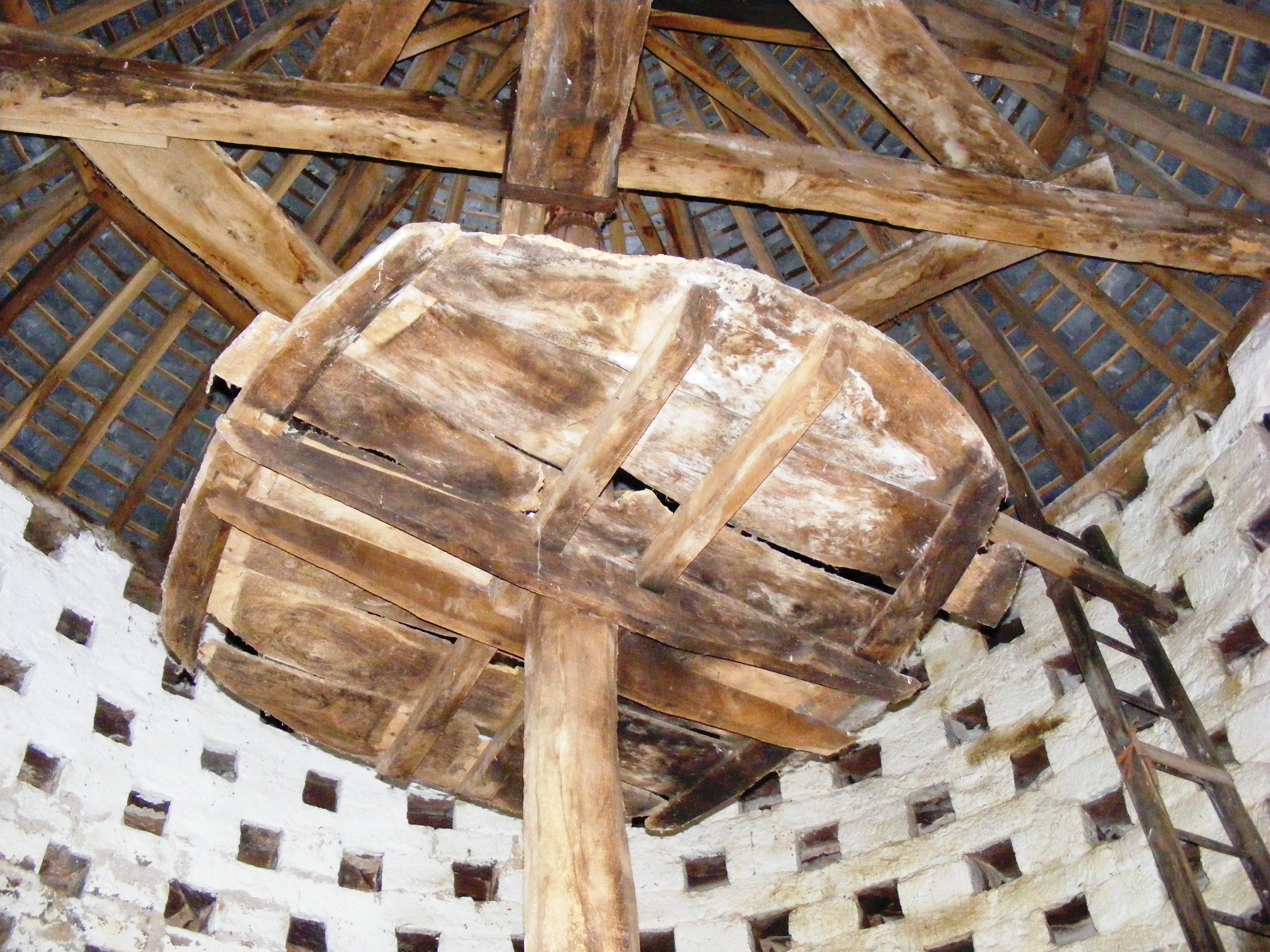
 The interior showing the feeding platform, ladder and nest holes
In the 18th century the floor level and door were raised among several major alterations. The lower tiers of nest holes were blocked to protect against Brown Rats which had arrived in the Britain in 1720 and reached Somerset by 1760. A revolving ladder, known as a "potence", was installed to allow the pigeon keeper to search the nest holes more easily. In the 19th century two feeding platforms were added to the axis of the revolving ladder.[5]
When the Dunster Castle estate was sold the Dovecote was bought by the Parochial church council and opened to the public. Extensive repairs were undertaken in 1989.
References
- ^ a b "Dovecote". Images of England. English Heritage. http://www.imagesofengland.org.uk/Details/Default.aspx?id=264714. Retrieved 2009-06-04.
- ^ "Dovecote, Priory Green, Dunster". Somerset Historic Environment Record. Somerset County Council. http://webapp1.somerset.gov.uk/her/details.asp?prn=34982. Retrieved 2009-06-04.
- ^ a b Cooke, A.O.. "Somerset and Devon". Book of Dovecotes. Chapter 17. http://www.pigeoncote.com/dovecote/cooke17.html. Retrieved 2009-06-04.
- ^ Ballard, Barbara. "Dunster Somerset". Britain Express. http://www.britainexpress.com/villages/dunster.htm. Retrieved 2009-06-04.
- ^ "Dovecote, Dunster". Somerset Historic Environment Record. Somerset County Council. http://webapp1.somerset.gov.uk/her/details.asp?prn=34618. Retrieved 2009-06-04.
Categories:- 16th-century architecture
- Grade II* listed buildings in Somerset
- West Somerset
- Scheduled Ancient Monuments in Somerset
- Agricultural buildings

Wikimedia Foundation. 2010.