- Cutcombe
-
Coordinates: 51°08′30″N 3°31′52″W / 51.1417°N 3.5312°W
Cutcombe 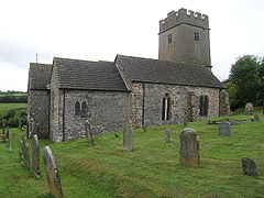
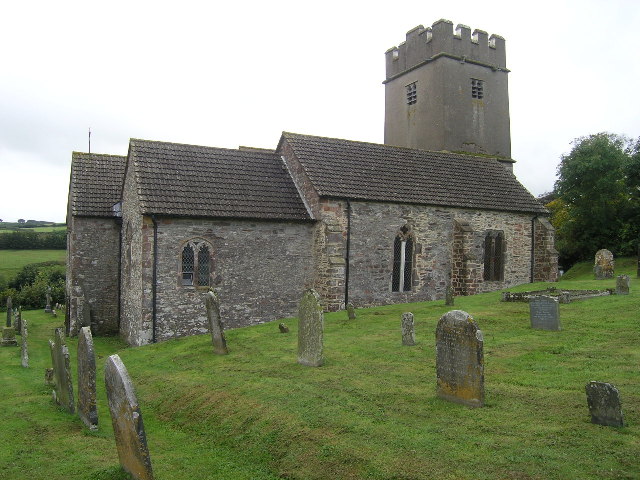
Church of St John, Cutcombe
 Cutcombe
Cutcombe shown within SomersetPopulation 403 [1] OS grid reference SS929391 District West Somerset Shire county Somerset Region South West Country England Sovereign state United Kingdom Post town MINEHEAD Postcode district TA24 Dialling code 01643 Police Avon and Somerset Fire Devon and Somerset Ambulance South Western EU Parliament South West England UK Parliament Bridgwater and West Somerset List of places: UK • England • Somerset Cutcombe is a village and civil parish 9 miles (14 km) south of Minehead and north of Dulverton straddling the ridge between Exmoor and the Brendon Hills in Somerset. It has a population of 403.[1]
The parish includes the village of Wheddon Cross which is one of the higher villages within the Exmoor National Park at 980 feet (299 m) above sea level, the highest being Simonsbath.
Contents
History
Cutcombe comes from Old English meaning Cuda's valley and was granted after the Norman Conquest to William de Mohun of Dunster.[2]
Cutcombe was part of the hundred of Carhampton.[3]
Cutcombe Market has been a long established livestock market. A partnership involving Somerset County Council, Exmoor National Park Authority, the South West of England Regional Development Agency and West Somerset Council, have put together plans to revitalise the market and add housing, industrial units and a Exmoor National Park Interpretation Centre on the site. Somerset Rural Renaissance Partnership have invested over £300,000 towards the project which is expected to complete in 2011.[4]
Governance
The parish council has responsibility for local issues, including setting an annual precept (local rate) to cover the council’s operating costs and producing annual accounts for public scrutiny. The parish council evaluates local planning applications and works with the local police, district council officers, and neighbourhood watch groups on matters of crime, security, and traffic. The parish council's role also includes initiating projects for the maintenance and repair of parish facilities, as well as consulting with the district council on the maintenance, repair, and improvement of highways, drainage, footpaths, public transport, and street cleaning. Conservation matters (including trees and listed buildings) and environmental issues are also the responsibility of the council.
The village falls within the Non-metropolitan district of West Somerset, which was formed on 1 April 1974 under the Local Government Act 1972, having previously been part of Williton Rural District.[5] The district council is responsible for local planning and building control, local roads, council housing, environmental health, markets and fairs, refuse collection and recycling, cemeteries and crematoria, leisure services, parks, and tourism.
Somerset County Council is responsible for running the largest and most expensive local services such as education, social services, libraries, main roads, public transport, policing and fire services, trading standards, waste disposal and strategic planning.
It is also part of the Bridgwater and West Somerset county constituency represented in the House of Commons of the Parliament of the United Kingdom. It elects one Member of Parliament (MP) by the first past the post system of election, and part of the South West England constituency of the European Parliament which elects seven MEPs using the d'Hondt method of party-list proportional representation.
Religious sites
The parish church of St John has a 13th-century tower and has been designated by English Heritage as a Grade II* listed building.[6]
References
- ^ a b "Cutcombe". Exmoor National Park. http://www.exmoor-nationalpark.gov.uk/index/learning_about/general_information/exmoor_parishes/cutcombe.htm. Retrieved 7 December 2007.
- ^ Bush, Robin (1994). Somerset: The complete guide. Wimborne, Dorset: Dovecote Press. pp. 80. ISBN 1874336261.
- ^ "Carhampton Hundred". Domesday Map. http://www.domesdaymap.co.uk/hundred/carhampton/. Retrieved 23 September 2011.
- ^ "Cutcombe Market". Somerset Rural Renaissance. http://www.somerset-rural-renaissance.co.uk/projects-cutcombe-market.html. Retrieved 14 May 2010.
- ^ A Vision of Britain Through Time : Williton Rural District
- ^ "Church of St John". Images of England. http://www.imagesofengland.org.uk/details/default.aspx?id=265319. Retrieved 7 December 2007.
External links
Towns, villages and hamlets in the West Somerset district of Somerset, England 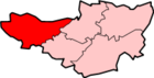 Allerford · Ashbeer · Bicknoller · Brandish Street · Brompton Ralph · Brompton Regis · Brushford · Carhampton · Clatworthy · Cockercombe · Crowcombe · Culbone · Cutcombe · Dulverton · Dunster · East Quantoxhead · Elworthy · Exford · Exton · Holford · Huish Champflower · Kilve · Lilstock · Luccombe · Luxborough · Minehead · Monksilver · Oare · Old Cleeve · Porlock · Roadwater · Sampford Brett · Selworthy · Simonsbath · Skilgate · Stogumber · Stogursey · Stringston · Timberscombe · Treborough · Upton · Washford · Watchet · West Quantoxhead · Williton · Winsford · Withycombe · Withypool · Wootton CourtenayCategories:
- Exmoor
- Villages in West Somerset
- Civil parishes in Somerset


Wikimedia Foundation. 2010.