Clyst Honiton

Clyst Honiton
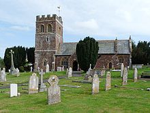
Clyst Honiton Church

Clyst Honiton is an English village and civil parish five miles from Exeter in the East Devon district, in the county of Devon. It has a primary school.[1] The church is St Michael and All Angels.[2][3] Exeter International Airport which was opened in 1938 is located on the outskirts of the village.[4] The village was originally on the main A30 road from Exeter to Honiton but was Bypassed in the 1990s.[citation needed] In 2001 the population of the civil parish of Clyst Honiton was 295.[5]

References

  1. ^ "Clyst Honiton Primary School". Clysthoniton.devon.sch.uk. http://www.clysthoniton.devon.sch.uk/. Retrieved 2011-07-16. 
  2. ^ A Church Near You. "St Michael and All Angels, Clyst Honiton - Devon | Diocese of Exeter". Achurchnearyou.com. http://www.achurchnearyou.com/clyst-honiton-st-michael-all-angels/. Retrieved 2011-07-16. 
  3. ^ Good Stuff IT Services (1961-06-30). "Church of St Michael - Clyst Honiton - Devon - England". British Listed Buildings. http://www.britishlistedbuildings.co.uk/en-352342-church-of-st-michael-clyst-honiton. Retrieved 2011-07-16. 
  4. ^ "Exeter Airport Opened" (News). The Times (London). Monday, 1 August 1938. Issue 48061, col E, p. 7.
  5. ^ Neighbourhood Statistics. "Check Browser Settings". Neighbourhood.statistics.gov.uk. http://www.neighbourhood.statistics.gov.uk/dissemination/LeadTableView.do?a=3&b=793500&c=clyst&d=16&e=15&g=435690&i=1001x1003x1004&m=0&r=1&s=1310482876426&enc=1&dsFamilyId=779. Retrieved 2011-07-16. 

External links

Coordinates: 50°44′N 3°26′W / 50.733°N 3.433°W / 50.733; -3.433


Wikimedia Foundation. 2010.

Игры ⚽ Нужна курсовая?

Look at other dictionaries:

  • Clyst Rovers F.C. — Clyst Rovers Full name Clyst Rovers Football Club Nickname(s) The Rovers Founded 1951 Ground …   Wikipedia

  • Clyst St Mary — Coordinates: 50°42′33″N 3°27′18″W / 50.709274°N 3.455029°W / 50.709274; 3.455029 …   Wikipedia

  • River Clyst — The River Clyst is a river of England. The river runs through the county of Devon.Rising near the village of Clyst William near Cullompton, the river runs west and southwest, flowing through the settlements of Norman s Green, Plymtree, Clyst… …   Wikipedia

  • List of civil parishes in Devon — Blank map of civil parish boundaries in Devon This is a list of civil parishes in the ceremonial county of Devon, England. Contents 1 Ea …   Wikipedia

  • Otterton — Coordinates: 50°39′29″N 3°18′04″W / 50.658178°N 3.301008°W / 50.658178; 3.301008 …   Wikipedia

  • Devon County Council — Type Type Unicameral of county council …   Wikipedia

  • Dean Prior — St George Martyr, Dean Prior Dean Prior is a village and civil parish near the A38 road, in the South Hams district, in the county of Devon, England. It is located near the town of Buckfastleigh. Dean Prior has a church called St George Martyr,… …   Wikipedia

  • List of places in Devon — This is a list of settlements and places of interest in Devon, England. See List of places in England for settlements in other counties. NOTOC A*Abbots Bickington *Abbotsham *Abbotskerswell *Alverdiscott *Appledore (Mid Devon) *Appledore (North… …   Wikipedia

  • Trafalgar Way — The Trafalgar Way is the name given to the historic route used to carry dispatches with the news of the Battle of Trafalgar overland from Falmouth to the Admiralty in London. The first messenger in November 1805 was Lieutenant Lapenotiere, of HMS …   Wikipedia

  • New Trafalgar Dispatch — Arrival in Lyme Regis T …   Wikipedia

Share the article and excerpts

Direct link
Do a right-click on the link above
and select “Copy Link”