- Novinger, Missouri
-
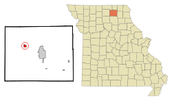
Novinger, Missouri — City — Location of Novinger, Missouri Coordinates: 40°14′00″N 92°42′23″W / 40.2333333°N 92.70639°W Country United States State Missouri County Adair Township Nineveh Area – Total 0.8 sq mi (2.1 km2) – Land 0.8 sq mi (2.1 km2) – Water 0.0 sq mi (0.0 km2) Elevation 787 ft (240 m) Population (2010) – Total 456 – Density 662.7/sq mi (255.9/km2) Time zone Central (CST) (UTC-6) – Summer (DST) CDT (UTC-5) ZIP code 63559 Area code(s) 660 FIPS code 29-53534[1] GNIS feature ID 0723530[2] Novinger is a city in Nineveh Township, Adair County, Missouri, United States. The population was 456 at the 2010 census. It is part of the Kirksville Micropolitan Statistical Area.
Contents
Geography
Novinger is located at 40°14′00″N 92°42′23″W / 40.233198°N 92.706504°WCoordinates: 40°14′00″N 92°42′23″W / 40.233198°N 92.706504°W (40.233198, -92.706504).[3]
According to the United States Census Bureau, the city has a total area of 0.8 square miles (2.1 km2), of which, 0.8 square miles (2.1 km2) of it is land and 0.04 square miles (0.10 km2) of it (2.44%) is water. Novinger can be found on the north side of Missouri Highway 6, approximately seven miles west of Kirksville, Missouri. Missouri Highway 149 bisects the town on a north-south axis, while Adair County Route "O", travels through the main downtown business district.
History
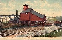
Key events in Novinger history include the arrival of the Quincy, Missouri & Pacific railroad and filing of the town plat by founder John C. Novinger in 1878, the establishment of a U.S. Post Office the next year, and the first shaft coal mine in 1883. A turn-of-the-century coal mining boom saw Welsh, Germans, Scots-Irish, Italians, natives of the Balkan countries and many others and their families immigrate from all over the world. It was this boom that finally saw Novinger incorporated as a city in 1901 as the population swelled into the thousands. However, the Great Depression, a post-World War Two switch to mostly natural gas and electric heat in American homes, and heavy industry’s lessening coal use doomed the area coal fields. The railroads had pulled out by 1950, and the last mine, Billy Creek Coal Mine southwest of Novinger, closed in January 1966. At the time of its closing Billy Creek was the last operating deep shaft mine in Missouri.
Novinger versus Nature: Being a river town, Novinger was no stranger to frequent flooding of the Chariton River during the communitys early years. However a channelization of the Chariton by the U.S. Army Corps of Engineers in the 1950s alleviated much of the threat. But in June 2008 a series of heavy rains led to flooding of the Chariton, and more significantly, left flash flood waters of Spring Creek and Davis Creek to back up from the river into Novinger. Several homes in the low-lying southwestern part of town were heavily damaged, as was the historic 1800s log homestead and Novinger Community Center. On May 13, 2009 a large tornado, estimated as a strong EF2 on the Fujita Scale, struck the southern edge of Novinger. At least six homes were destroyed, along with two brick buildings in the business district. The tornado caused moderate-to-severe damage to over fifty homes and businesses. Fortunately only minor injuries to residents were reported. Additionally, other homes and barns were also badly damaged or destroyed in rural Adair County southwest of Novinger. Adding insult to injury two days later on May 15 heavy rains once again caused severe flash flooding to Novinger’s low-lying areas, including once again the Novinger Community Center and log homestead -— both of which had only recently been repaired from damage suffered in the June 2008 flood. The combination of tornado and flood forced the first-ever cancellation of Novingers annual Coal Miner Days celebration as well as postponement of graduation ceremonies at Novinger R-1 High School.
Late on the night of September 11, 2010 a major fire swept through the Novinger business district. Five buildings, including the former city hall and senior citizen center were destroyed, as well as two businesses.
Novinger Today
The Novinger business community is but a fraction of its size during the coal boom days. The town proper and surrounding area offer two beauty salons, two construction companies, a convenience store, catering business, farm supply store, heating & cooling repair, and auction service. Most Novinger residents, however, must travel to the larger city of Kirksville to the east or Milan to the west, to find employment, thus making Novinger a "bedroom community" of sorts. Novinger still has an active K-12 school. Recent improvements include storm warning capability, water system, and community grounds. Fire protection is provided by a well equipped volunteer fire department as well. Recreation activities include deer and turkey hunting, along with fishing in the nearby lakes, ponds and the Chariton River, boating and waterskiing at Thousand Hills State Park, four miles east of Novinger. There is a reconstructed historic log homestead and Coal Miners’ Museum. A community center hosts private functions and annual town celebrations. Novinger Renewal Inc., Novinger Planned Progress, and the Novinger Lions Club are three civic organizations.
Annual events
- Each Memorial Day weekend Coal Miner Days includes a parade, games, food, and entertainment.
- Each Labor Day weekend the Novinger Lions Club hosts a celebration with parade, food and games.
- At the Novinger Renewal Christmas Country Crafts Fair held the Saturday before Thanksgiving, artisans from across the tri-state area display their work.
- The week after Thanksgiving includes the annual Novinger Invitational basketball tournament.
Notable residents
- Zachary Wyatt, 2nd District Representative, Missouri House of Representatives.
- Brent Truitt, Grammy Award winning music producer, recording engineer and musician.
- Sally (Sandker) Berry and Tensel Sandker, members of Bluegrass music group Next Best Thing. Both attended Novinger R-1 schools for elementary and most of high school.
Demographics
Historical populations Census Pop. %± 1910 1,711 — 1920 1,743 1.9% 1930 846 −51.5% 1940 793 −6.3% 1950 734 −7.4% 1960 621 −15.4% 1970 547 −11.9% 1980 626 14.4% 1990 542 −13.4% 2000 534 −1.5% 2010 456 −14.6% As of the census[1] of 2010, there were 456 people, 225 households, and 152 families residing in the city. The population density was 662.7 people per square mile (254.5/km²). There were 246 housing units at an average density of 305.3 per square mile (117.3/km²). The racial makeup of the city was 99.25% White and 0.75% Native American. Hispanic or Latino of any race were 1.50% of the population.
There were 225 households out of which 33.3% had children under the age of 18 living with them, 51.1% were married couples living together, 12.0% had a female householder with no husband present, and 32.4% were non-families. 29.8% of all households were made up of individuals and 15.1% had someone living alone who was 65 years of age or older. The average household size was 2.37 and the average family size was 2.95.
In the city the population was spread out with 25.1% under the age of 18, 10.9% from 18 to 24, 24.3% from 25 to 44, 25.1% from 45 to 64, and 14.6% who were 65 years of age or older. The median age was 37 years. For every 100 females there were 103.0 males. For every 100 females age 18 and over, there were 93.2 males.
The median income for a household in the city was $20,990, and the median income for a family was $26,000. Males had a median income of $19,500 versus $17,625 for females. The per capita income for the city was $10,586. About 14.9% of families and 15.6% of the population were below the poverty line, including 19.7% of those under age 18 and 15.8% of those age 65 or over.
References
- ^ a b "American FactFinder". United States Census Bureau. http://factfinder.census.gov. Retrieved 2008-01-31.
- ^ "US Board on Geographic Names". United States Geological Survey. 2007-10-25. http://geonames.usgs.gov. Retrieved 2008-01-31.
- ^ "US Gazetteer files: 2010, 2000, and 1990". United States Census Bureau. 2011-02-12. http://www.census.gov/geo/www/gazetteer/gazette.html. Retrieved 2011-04-23.
4. Novinger, Adair County, Missouri: The People, The Town, and The Surrounding Communities Published by Novinger Renewal Inc., April 2001.
5. Living History - Again by Danny Ellsworth, Novinger Renewal newsletter Volume 22 Issue 3, Summer 2009
External links
- Historic maps of Novinger in the Sanborn Maps of Missouri Collection at the University of Missouri
Municipalities and communities of Adair County, Missouri Cities Brashear | Greentop‡ | Kirksville | Novinger
Villages Townships Unincorporated
communitiesFootnotes ‡This populated place also has portions in an adjacent county or counties
Categories:- Cities in Adair County, Missouri
- Kirksville micropolitan area
Wikimedia Foundation. 2010.


