- Interstate 40 in Oklahoma
-
This article is about the section of Interstate 40 in Oklahoma. For the entire length of the highway, see Interstate 40.
Interstate 40

Route information Maintained by ODOT Length: 331 mi (533 km) Existed: 1957[1] – present Major junctions West end:  I-40 at the Texas state line
Muskogee Tpk. near Webbers Falls US-81 in El Reno
 I-44 in Oklahoma City
 I-35 in Oklahoma City
 I-235 in Oklahoma City
 I-240 in Oklahoma City
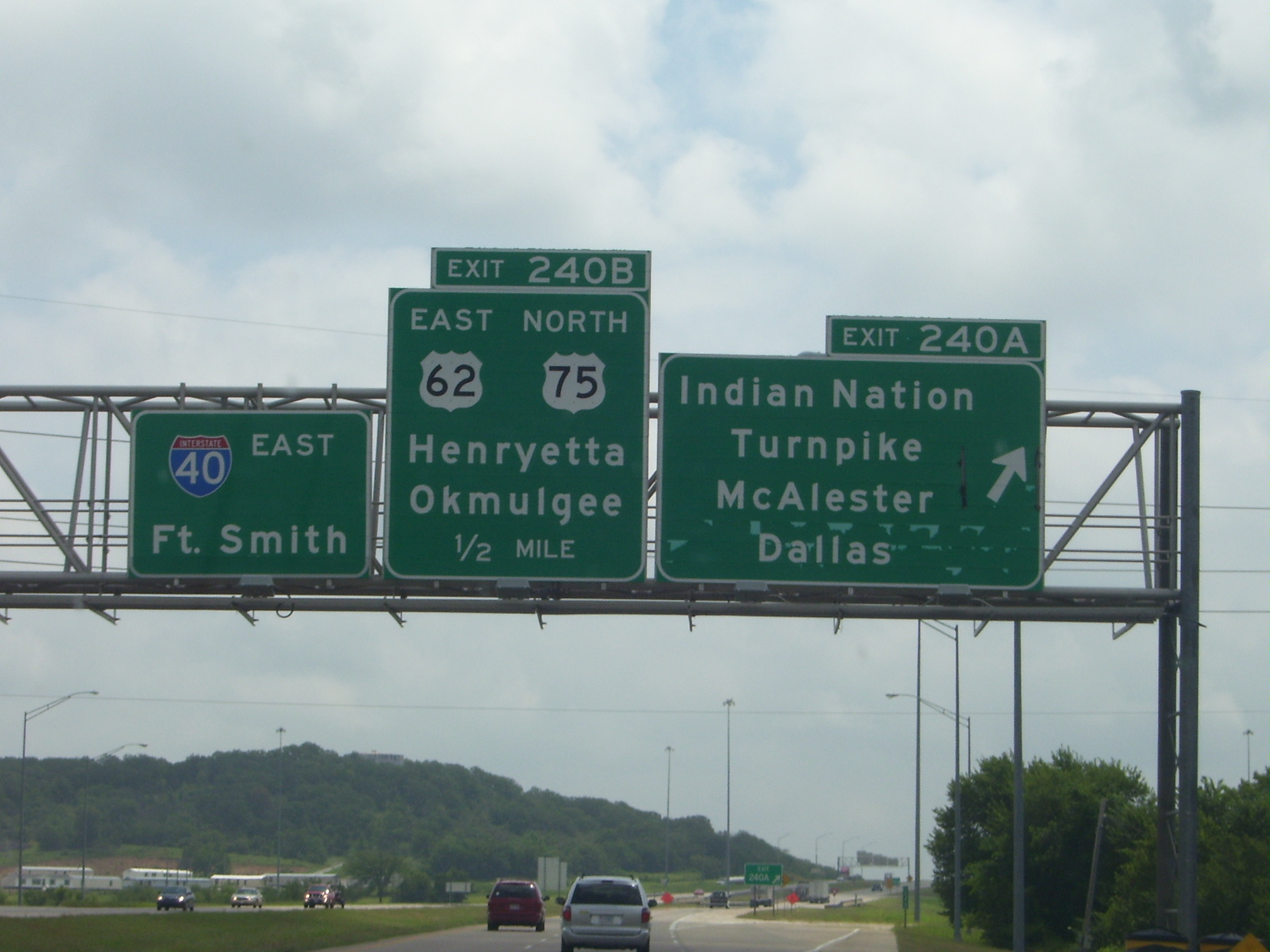
Indian Nation Tpk. in Henryetta
 US-69 in Checotah
East end:  I-40 at the Arkansas state line
Highway system Main route of the Interstate Highway System
Main • Auxiliary • BusinessOklahoma State Highways
Oklahoma turnpike system←  SH-39
SH-39SH-42  →
→Interstate 40 (I-40) is an Interstate Highway in Oklahoma that runs 331 miles (530 km) across the state from Texas to Arkansas. West of Oklahoma City, it parallels and replaces Old US-66, and east of Oklahoma City, it parallels US-62, US-266 and US-64.
Cities along the route include Erick, Sayre, Elk City, Clinton, Weatherford, El Reno, Oklahoma City, Shawnee, Okemah, Henryetta, Checotah and Sallisaw.
Contents
Route description
Interstate 40 enters Oklahoma near Texola, in Beckham County. It crosses the North Fork of the Red River near Sayre and runs through the south side of Elk City. It then cuts across the northwest corner of Washita County before entering Custer County, where it passes through Clinton and Weatherford. After leaving Weatherford, I-40 then runs across the northern tip of Caddo County before it enters Canadian County.
I-40 runs through the south side of El Reno, entering the Oklahoma City metro. It then passes through Yukon before entering Oklahoma City proper. There, it has a junction with Interstate 44 (the Amarillo Junction). It then runs just south of downtown Oklahoma City on an elevated, dilapidated structure called the I-40 Crosstown, which is scheduled for replacement in 2012. It next meets Interstate 35 in the Fort Smith Junction complex, forming a concurrency with it for about two miles (3 km). It then passes through Del City and Midwest City on a freeway known as the Tinker Diagonal, providing access to Tinker Air Force Base in Oklahoma City.
In far eastern Oklahoma City, I-40 meets Interstate 240 in a partial junction before passing through the north side of Shawnee. In Henryetta, I-40 serves as the northern terminus of the Indian Nation Turnpike. In McIntosh County, it crosses the northernmost arm of Lake Eufaula and meets the US-69 freeway south of Checotah.
Near Webbers Falls, I-40 is the southern terminus of the Muskogee Turnpike. It then crosses the Arkansas River before heading around southern Sallisaw. The interstate crosses into Arkansas north of Moffett.
History

West of Oklahoma City, Interstate 40 parallels and replaces Old US-66. US-66 was decommissioned in Oklahoma in 1985.
The I-40 bridge over the Arkansas River/McClellan-Kerr Navigation System near Webbers Falls was struck by a barge on May 26, 2002, causing the bridge to collapse and resulting in the death of 14 people.
Future
The I-40 Crosstown Oklahoma City Crosstown was built in 1966[citation needed], is too narrow for existing traffic, and is very dilapidated. Current plans call for I-40 to be relocated a few blocks south of the exiting route, the elevated route torn down, and a landscaped boulevard built on the old right-of-way, similar to the I-30 reconstruction through downtown Fort Worth, Texas.
Business routes and old alignments
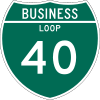
I-40 has eight business routes in Oklahoma, six of which are old alignments of US-66. A number of other old alignments of US-66 are also present west of Oklahoma City.
Erick I-40 Business Loop (formerly US-66) is a Business Loop that runs from I-40 two miles (3 km) west of Erick to the old alignment of US-66, through Erick, and back to I-40, four miles (6 km) east of Erick.
Sayre I-40 Business Loop (formerly US-66) is a Business Loop that begins two miles (3 km) south of Sayre at US-283, runs north into the coty, and then leaves Sayre to the east, rejoining I-40 two miles (3 km) east of US-283.
Elk City I-40 Business Loop (formerly US-66) is a Business Loop that begins at Exit 32, seven miles (11 km) west of Elk City. It runs for ten miles (16 km) through Elk City, rejoining I-40 at Exit 41.
Clinton I-40 Business Loop (formerly US-66) is a Business Loop that begins at Exit 65, runs five miles (8 km) through Clinton, and rejoinds I-40 at Exit 69.
Weatherford I-40 Business Loop (formerly US-66) is a Business Loop that exits I-40 at Exit 82B, runs four miles (6 km) through Weatherford, and rejoins I-40 at Exit 82.
El Reno I-40 Business Loop (formerly US-66) is a Business Loop through El Reno. It exits I-40 at Exit 119, runs eight miles (13 km) through El Reno, and rejoins I-40 at Exit 125, the interchange with US-81.
Henryetta I-40 Business Loop (formerly US-62/US-75) is a Business Loop that leaves I-40 at Exit 237, runs four miles (6 km) through Henryetta, and rejoins I-40 at Exit 240, the interchange with US-75 and the Indian Nation Turnpike.
Sallisaw I-40 Business Loop is a Business Loop that leaves I-40 at Exit 308, US-59, runs four miles (6 km) through Sallisaw, and rejoins I-40 at Exit 311, US-64.
Exit list
 Exit 176
 Exit 181
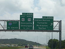 Exit 240A
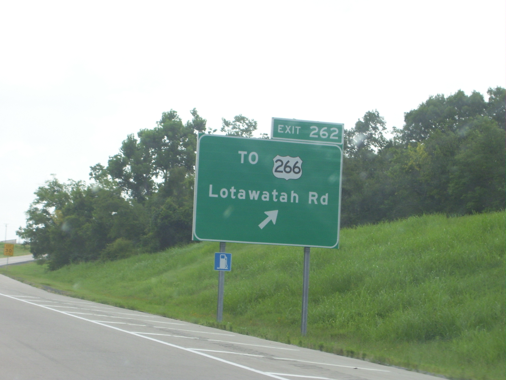
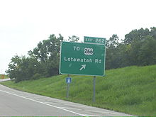 Exit 262
County Location Mile # Destinations Notes  I-40 enters Texas
Beckham 1 Texola 5  BL I-40 east (Honeyfarm Road) – Erick
Erick 7  SH-30 – Erick, Sweetwater
11 BL I-40 west – Erick14 Hext Road Sayre 20  BL I-40 east / US-283 (South 4th Street) – Mangum
23  SH-152 (Main Street) – Cordell
25 BL I-40 west (North 4th Street)26 Cemetery Road 32  BL I-40 east / SH-34 south – Carter, Mangum, Elk City
34 Merritt Road Elk City 38  SH-6 (South Main Street) – Altus
40 East 7th Street 41 BL I-40 west / SH-34 north – Woodward, Elk CityWashita 47 Canute 50 Clinton Lake Road 53  SH-44 – Foss, Altus
Custer 57 Stafford Road 61 Haggard Road 62 Parkersburg Road Clinton 65 BL I-40 east (Gary Boulevard)No eastbound entrance 65A 10th Street, Neptune Drive 66  US-183 (South 4th Street) – Cordell
69 BL I-40 west – ClintonWestbound exit and eastbound entrance 71 Custer City Road 80  SH-54 – Thomas
Weatherford 80A BL I-40 east (West Main Street) – Southwestern Oklahoma State UniversityEastbound exit and westbound entrance 82 BL I-40 west (East Main Street)84 Airport Road Caddo 88  SH-58 – Hydro, Carnegie
95 Bethel Road 101 
 US-281 / SH-8 – Hinton, Anadarko
Canadian 104 Methodist Road 108 
US-281 Spur north – Geary, Watonga115  US-270 west – Calumet
West end of US-270 overlap 119 BL I-40 east – El RenoEl Reno 123 Country Club Road 125 BL I-40 west / US-81 – El Reno, Chickasha130 Banner Road 132 Cimarron Road – C.E. Page Airport Yukon 136  SH-92 – Yukon, Mustang
137 Cornwell Drive, Czech Hall Road 138  SH-4 (Mustang Road) – Yukon, Mustang
Westbound exit via exit 139 139 Kilpatrick Turnpike east 140 Morgan Road Oklahoma Oklahoma City 142 Council Road 143 Rockwell Avenue 144 MacArthur Boulevard 145 Meridian Avenue 146 Portland Avenue Eastbound exit and westbound entrance 147A  I-44 / SH-3 – Lawton, Tulsa
Signed as exits 147A (west) and 147B (east) 147C May Avenue – Fair Park Westbound exit and eastbound entrance 148A Agnew Avenue, Villa Avenue 148B Penn Avenue Eastbound exit and westbound entrance 148C Virginia Avenue Westbound exit and eastbound entrance 149A Western Avenue, Reno Avenue, Sheridan Avenue 149B Classen Boulevard Westbound exit and eastbound entrance 150A Walker Avenue – Downtown Oklahoma City Eastbound exit and westbound entrance 150B Harvey Avenue Eastbound exit only 150C Robinson Avenue, E.K. Gaylord Boulevard, Shields Boulevard – Downtown Oklahoma City No eastbound exit 151A Lincoln Boulevard Eastbound exit only. Closed due to construction of the new I-40 Crosstown. 151B  I-35 south / US-62 west (US-77 south) – Dallas
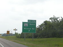
West end of I-35/US-62 overlap 151C I-235 north (US-77 north) – Edmond, State Capitol, Oklahoma Health CenterSigned as exit 126 westbound 127 Eastern Avenue, M. L. King Avenue Eastbound exit and westbound entrance 153 I-35 north / US-62 east to I-44 – Tulsa, WichitaEast end of I-35/US-62 overlap Del City 154 Reno Avenue, Scott Street 155A Sunny Lane Road – Del City 155B Southeast 15th Street – Del City, Midwest City Midwest City 156A Sooner Road 156B Hudiburg Drive No eastbound entrance 157A Southeast 29th Street – Midwest City Eastbound exit only 157B Air Depot Bloulevard - Tinker Gate 157C Town Center Drive - Eaker Gate 159A Hruskocy Gate 159B Douglas Boulevard – Midwest City, Tinker Air Force Base Gates Oklahoma City 162 Anderson Road 165 I-240 west (SH-3) – Lawton, DallasWest end of SH-3 overlap; westbound exit and eastbound entrance 166 Choctaw Road 169 Peebly Road 172 Newalla Road – Harrah Pottawatomie 176  SH-102 north (McLoud Road)
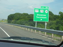
West end of SH-102 overlap 178 SH-102 south – Dale, Bethel AcresEast end of SH-102 overlap 181 
 US-177 / US-270 east / SH-3W east – Shawnee, Tecumseh
East end of US-270 overlap Shawnee 185  SH-3E east – Shawnee
186  SH-18 – Shawnee, Meeker
192  SH-9A south – Earlsboro
Seminole 200 
 US-377 / SH-99 – Prague, Seminole
212  SH-56 – Cromwell, Wewoka
Okfuskee 217  SH-48 – Holdenville, Bristow
221  US-62 west / SH-27 – Okemah, Wetumka
West end of US-62 overlap 227 Clearview Road 231  US-75 south – Wetumka - Weleetka
West end of US-75 overlap Okmulgee Henryetta 237 BL I-40 east – Henryetta240A Indian Nation Turnpike – McAlester, Dallas 240B US-62 east / US-75 north / BL I-40 west – OkmulgeeEast end of US-62/US-75 overlap McIntosh 247 Tiger Mountain Road 255 Pierce Road 259  SH-150 (Lake Eufaula Road)
262  To US-266 / Lotawatah Road
264 US-69 – Eufaula, McAlester, DallasSigned as exits 264A (south) and 264B (north) 265 
US-69 Bus. – Checotah270 Texanna Road – Porum Landing Muskogee 278  US-266 / SH-2 – Muskogee, Warner, Porum
284 Ross Road 286 Muskogee Turnpike west – Muskogee, Tulsa 287  SH-100 north – Webbers Falls, Gore
Sequoyah 291  SH-10 north (Carlisle Road) – Gore
297  SH-82 – Vian, Tahlequah
303 Dwight Mission Road Sallisaw 308  BL I-40 east / US-59 – Salisaw, Poteau
311  BL I-40 west / US-64 – Salisaw, Stilwell
321  SH-64B north – Muldrow
325 US-64 – Roland, Fort Smith330  SH-64D south – Dora, Fort Smith
Eastbound exit and wesbound entrance  I-40 enters Arkansas
See also
References
- ^ Froehlig, Adam. Scans from the "Yellow Book". Froggie's Place. URL accessed 20 September 2006.
External links
Interstate 40Previous state:
TexasOklahoma Next state:
ArkansasCategories:- Interstate Highways in Oklahoma
- Interstate 40


Wikimedia Foundation. 2010.