- Clark Fork (river)
-
Clark Fork River 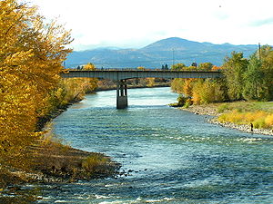 Clark Fork, Missoula, Montana
Country United States States Montana, Idaho Tributaries - left Bitterroot River - right Blackfoot River, Flathead River Cities Butte, Missoula Source Silver Bow Creek - location Butte, Silver Bow County, Montana - elevation 6,882 ft (2,098 m) [1] - coordinates 46°4′32″N 112°27′56″W / 46.07556°N 112.46556°W [2] Secondary source Warm Springs Creek - location Flint Creek Range, Granite County, Montana - elevation 7,466 ft (2,276 m) [3] - coordinates 46°15′39″N 113°8′12″W / 46.26083°N 113.13667°W [4] Source confluence - location Deer Lodge County, Montana - elevation 4,795 ft (1,462 m) [5] - coordinates 46°11′12″N 112°46′18″W / 46.18667°N 112.77167°W [6] Mouth Lake Pend Oreille - location Bonner County, Idaho - elevation 2,064 ft (629 m) [7] - coordinates 48°11′0″N 116°16′9″W / 48.183333°N 116.26917°W [6] Length 310 mi (499 km) [6] Basin 22,905 sq mi (59,324 km2) [8] Discharge for Whitehorse Rapids near Cabinet, ID - average 21,930 cu ft/s (621 m3/s) [9] - max 195,000 cu ft/s (5,522 m3/s) - min 762 cu ft/s (22 m3/s)  Map of the Clark Fork, its main tributaries and downriver connection to the Columbia River via the Pend Oreille River.
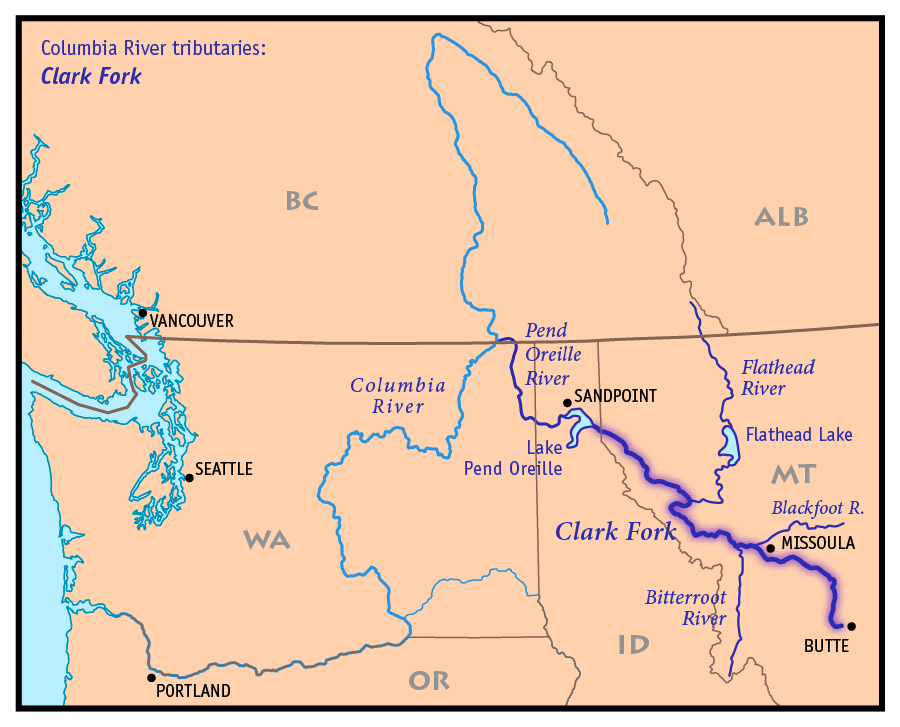
The Clark Fork is a river in the U.S. states of Montana and Idaho, approximately 310 miles (500 km) long. The largest river by volume in Montana, it drains an extensive region of the Rocky Mountains in western Montana and northern Idaho in the watershed of the Columbia River, flowing northwest through a long mountain valley and emptying into Lake Pend Oreille in northern Idaho. The Pend Oreille River, which drains the lake to the Columbia, is sometimes included as part of the Clark Fork, giving it a total length of 479 mi (771 km), with a drainage area of 25,820 sq mi (66,870 km²). In its upper 20 mi (32 km) in Montana near Butte, it is known as Silver Bow Creek. Interstate 90 follows much of the upper course of the river from Butte to northwest of Missoula.
The Clark Fork is a Class I river for recreational purposes in Montana from Warm Springs Creek to the Idaho border.[10]
The Clark Fork should not be confused with the Clarks Fork of the Yellowstone River, which is located in Montana and Wyoming.
Contents
Description
 Clark Fork flowing through downtown Missoula (2003)
It rises as Silver Bow Creek[2] in southwestern Montana, less than 5 mi (8 km) from the continental divide near downtown Butte, from the confluence of Basin and Blacktail creeks. It flows northwest and north through a valley in the mountains, passing east of Anaconda, where it changes its name to the Clark Fork at the confluence with Warm Springs Creek, then northwest to Deer Lodge. Near Deer Lodge it receives the Little Blackfoot River. From Deer Lodge it flows generally northwest across western Montana, passing south of the Garnet Range toward Missoula. Five miles east of Missoula, the river receives the Blackfoot River.
Northwest of Missoula, the river continues through a long valley along the northeast flank of the Bitterroot Range, through the Lolo National Forest. It receives the Bitterroot River from the south-southwest approximately 5½ mi west of downtown Missoula, and receives the Flathead River from the north near Paradise. It receives the Thompson River from the west near Thompson Falls in southern Sanders County.
At Noxon, Montana, along the north end of the Bitterroots near the Idaho border, the river is impounded by the Noxon Rapids Dam to form a 20 mi (32 km) long reservoir. It crosses into western Bonner County in northern Idaho near the town of Cabinet, Idaho. Approximately 5 mi (8 km) west of the Idaho-Montana state line, the river enters the eastern end of Lake Pend Oreille, near the town of Clark Fork.
History
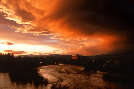
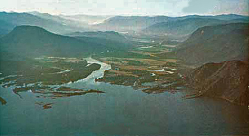
 The mouth of the Clark Fork on Lake Pend Oreille in Idaho
During the last ice age, from approximately 20,000 years ago, the Clark Fork Valley lay along the southern edge of the Cordilleran ice sheet covering western North America. The encroachment of the ice sheet formed an ice dam on the river, creating Glacial Lake Missoula which stretched through the Clark Fork Valley across central Montana. The periodic rupturing and rebuilding of the ice dam released the Missoula Floods, a series of catastrophic floods down the Clark Fork and Pend Oreille into the Columbia which sculptured many of the geographic features of eastern Washington and the Willamette Valley of Oregon.
In the 19th century the Clark Fork Valley was inhabited by the Flathead tribe of Native Americans. It was explored by Meriwether Lewis of the Lewis and Clark Expedition during the 1806 return trip from the Pacific. The river is named for William Clark. A middle segment of the river in Montana was formerly known as the Missoula River. The river was also referred to as the Deer Lodge River by Granville Stuart.
In 1809 David Thompson of the North West Company explored the region and founded several fur trading posts, including Kullyspell House at the mouth of the Clark Fork, and Saleesh House on the river near the present-day site of Thompson Falls, Montana. Thompson used the name Saleesh River for the entire Flathead-Clark Fork-Pend Oreille river system.[11] For most of the first half of the 19th century the Clark Fork river and surrounding region was controlled by the British-Canadian North West Company and Hudson's Bay Company.
Since the late 19th century many areas in the watershed of the river have been extensively mined for minerals, resulting in an ongoing stream pollution problem. Most pollution has come from the copper mines in Butte and the smelter in Anaconda. Many of the most polluted areas have been designated as Superfund sites. Nevertheless the river and its tributaries are among the most popular destinations for fly fishing in the United States.
Today, the Clark Fork watershed encompasses the largest Superfund site in America. As a mega-site, it includes three major sites: Butte, Anaconda, and Milltown Dam/Clark Fork River. Each of these major sites is split up into numerouse sub-sites known as Operable Units. Remediation and/or restoration of these sites is ongoing.
Conservation
- Tri-State Water Quality Council Citizens, business, industry, tribes, government and environmental groups combined to oversee the Clark Fork-Pend Oreille river system
- Clark Fork - Pend Oreille Conservancy non-profit land trust serving Sanders County, Montana and Bonner County, Idaho
- Clark Fork Coalition The coalition was founded in 1985 and is dedicated to protecting and restoring the Clark Fork River basin.
- Watershed Education Network (WEN)- WEN is a 501(c)(3) organization located in Missoula, Montana. WEN is a nonprofit organization dedicated to fostering knowledge, appreciation and awareness of watershed health through science, outreach, and education. Since 1996, WEN has been dedicated to growing the next generation of watershed stewards. WEN serves over 3,000 western Montana K–12 students annually through its School Stream Monitoring Program. Stream Monitoring field trips take place at 30 different stream sites across western Montana each fall and spring.
- Clark Fork Watershed Education Program - The program uses outdoor activities and local experts to teach about the effects of settlement and industry on the Upper Clark Fork basin, and to give students and educators the scientific background to quantify the health of our watershed.
See also
- Clarks Fork Yellowstone River
- Montana Stream Access Law
- List of Idaho rivers
- List of rivers of Montana
- Paradise Dam
- Milltown Reservoir Superfund Site
Additional reading
- Sullivan, Gordon (2008). Saving Homewaters-The Story of Montana’s Streams and Rivers. Woodstock, VT: The Countryman Press. ISBN 0-88150-679-2.
References
- ^ Google Earth elevation for GNIS Silver Bow Creek source coordinates.
- ^ a b U.S. Geological Survey Geographic Names Information System: Silver Bow Creek, USGS GNIS.
- ^ Google Earth elevation for GNIS Warm Springs Creek source coordinates.
- ^ U.S. Geological Survey Geographic Names Information System: Warm Springs Creek, USGS GNIS.
- ^ Google Earth elevation for GNIS Clark Fork source coordinates.
- ^ a b c U.S. Geological Survey Geographic Names Information System: Clark Fork, USGS GNIS.
- ^ Google Earth elevation for GNIS Clark Fork mouth coordinates.
- ^ Pend Oreille subbasin overview, Northwest Power and Conservation Council.
- ^ Montana Water Resources Data 2004, file Mill Creek above Bassoo Creek, near Niarada to Clark Fork at Whitehorse Rapids, near Cabinet, ID.
- ^ Stream Access in Montana
- ^ Nisbet, Jack (1994). Sources of the River: Tracking David Thompson Across Western North America. Sasquatch Books. pp. 1444–145, 149, 159. ISBN 1-57061-522-5.
External links
- Watershed Education Network(WEN)
- Clark Fork Watershed Education Program
- EcoRover, a blog about Superfund and other environmental issues in the upper Clark Fork River basin
- Clark Fork Coalition
- Upper Clark Fork Restoration Program
- Clark Fork River Operable Unit - US EPA Region 8
- Clark Fork River Technical Assistance Committee
 State of Montana
Helena (capital) Topics Index · History · Governors · People · Geography · State Government · Delegations · Visitor Attractions
Society Crime · Demographics · Economy · Education · Politics
Regions The Flathead · Glacier National Park · Regional designations of Montana · Western Montana · Yellowstone
Largest cities Counties Beaverhead · Big Horn · Blaine · Broadwater · Carbon · Carter · Cascade · Chouteau · Custer · Daniels · Dawson · Deer Lodge · Fallon · Fergus · Flathead · Gallatin · Garfield · Glacier · Golden Valley · Granite · Hill · Jefferson · Judith Basin · Lake · Lewis and Clark · Liberty · Lincoln · Madison · McCone · Meagher · Mineral · Missoula · Musselshell · Park · Petroleum · Phillips · Pondera · Powder River · Powell · Prairie · Ravalli · Richland · Roosevelt · Rosebud · Sanders · Sheridan · Silver Bow · Stillwater · Sweet Grass · Teton · Toole · Treasure · Valley · Wheatland · Wibaux · Yellowstone
Missoula, Montana Climate • Demographics • Economy • Government • Neighborhoods • Downtown Missoula Education High SchoolsBig Sky • Hellgate • Sentinel • Loyola Sacred Heart High School • Valley Christian • Willard Alternative High School • Sussex School • Clark Fork School • Next Step PrepHigher EducationUniversity of Montana • UM-College of TechnologyMuseumsFort Missoula • Montana Museum of Art & Culture • Missoula Art Museum
Geography MountainsRiversBitterroot • Blackfoot • Clark ForkHistory Media TelevisionPrintBreweries Bayern Brewing • Big Sky Brewing • Kettle House Brewing • Taproom only: Tamarack Brewing • Flathead Lake BrewingServices Health CareSt. Patrick Hospital and Health Sciences Center • Community Medical CenterTransportationSports TeamsMontana Grizzlies • Osprey (baseball) • Phoenix (semi-pro football) • Maulers (hockey) • Hellgate RollergirlsVenuesWashington–Grizzly Stadium (football) • Ogren Park at Allegiance Field (baseball) • Glacier Ice Rink (hockey) • Dornblaser Field (soccer) • Dahlberg Arena (basketball) • Western Montana Fair Grounds (horse racing)University of Montana Category • People from Missoula Categories:- Rivers of Idaho
- Rivers of Montana
- Tributaries of the Columbia River
- Rivers and Lakes of Missoula County, Montana
- Landforms of Bonner County, Idaho
- Landforms of Silver Bow County, Montana
- Landforms of Missoula County, Montana
- Landforms of Granite County, Montana
- Landforms of Deer Lodge County, Montana


Wikimedia Foundation. 2010.