- Noxon Rapids Dam
-
Noxon Rapids Dam 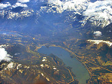
Aerial view of the reservoir and damLocation Sanders County, Montana Coordinates 47°57′36″N 115°44′4″W / 47.96°N 115.73444°W [1] Opening date 1960[2] Dam and spillways Height 179 ft (55 m)[2] Length 5,840 ft (1,780 m)[2] Impounds Clark Fork Reservoir Creates Noxon Reservoir Capacity 400,000 acre feet (490,000,000 m3)[2] Catchment area 21,800 sq mi (56,500 km²)[2] Surface area 7,940 acres (32.1 km²)[2] Noxon Rapids Dam is an earthfill gravity-type hydroelectric dam on the Clark Fork river, in the northwest part of the U.S. state of Montana.
The dam is located in the far northwest of Montana near the Idaho border. Downriver of Noxon Rapids Dam the Clark Fork is again impounded by the Cabinet Gorge Dam.
The operating capacity of Noxon Rapids Dam at full turbine flow and full pool is 466 MW.[3]
References
Categories:- Dams in Montana
- Hydroelectric power plants in Montana
- Buildings and structures in Sanders County, Montana
- Montana geography stubs

Wikimedia Foundation. 2010.