- Marquesas Keys
-
Marquesas Keys 
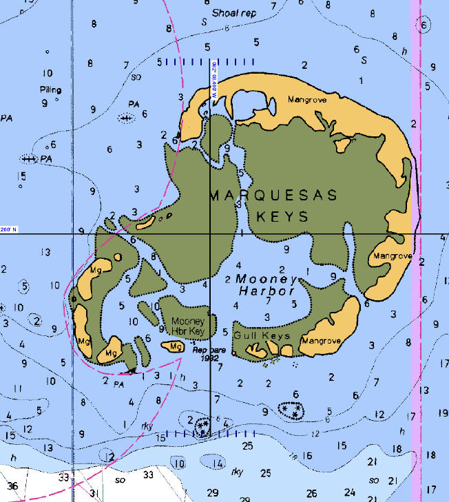
NOAA Nautical chart of the Marquesas Keys: part of Chart No. 11439 "Sand Key to Rebecca Shoal"Geography Location Caribbean Coordinates 24°34′19″N 82°07′10″W / 24.57194°N 82.11944°WCoordinates: 24°34′19″N 82°07′10″W / 24.57194°N 82.11944°W Archipelago Florida Keys Total islands 9 Major islands Entrance Key Area 6.58 km2 (2.541 sq mi) Country United StatesState Florida County Monroe County, Florida Census County Division Lower Keys Demographics Population 0 The Marquesas Keys form an uninhabited island group about 30 miles (50 km) west of Key West, 4 miles (6 km) in diameter, and inhabited by mangrove. They are an unincorporated area of Monroe County, Florida and belong to the Lower Keys Census County Division. They are protected as part of the Key West National Wildlife Refuge. The Marquesas were used for target practice by the military as recently as 1980.
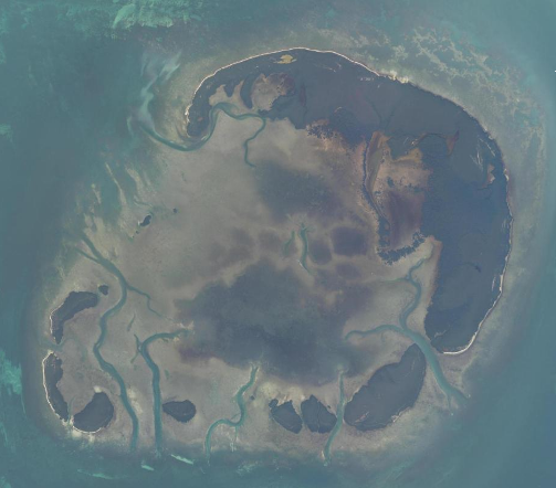
 Satellite Image of the Marquesas Keys
The total area, including the lagoon, measures 29.37 km². The land area, according to the United States Census Bureau, is 6.58 km² (exactly 6,579,703 m²), the water area 0.17 km² (165,744 m²), with a combined area 6,75 km² (6,745,447 m²), whereby water areas with connection to the open sea are not counted, but only small landlocked lakes on the Keys. The group is located at coordinates 24°34′19″N 82°07′10″W / 24.57194°N 82.11944°WCoordinates: 24°34′19″N 82°07′10″W / 24.57194°N 82.11944°W.
The islands are part of the Florida Keys, separated from the rest of the Florida Keys, which are farther east, by the Boca Grande Channel, which is 6 miles (10 km) wide until Boca Grande Key, the westernmost of the Mule Keys. Only the Dry Tortugas are farther west, 36 miles (60 km) west of the Marquesas Keys.
The central lagoon is called Mooney Harbor. The northernmost key is the largest and has a strip of sandy beach free of mangrove. In the past it was known as "Entrance Key". It surrounds the lagoon in the north and east. Adjoining in the south are smaller keys such as Gull Keys, Mooney Harbor Key, and finally about four unnamed keys in the southwest corner of the island. Older charts show that two of these keys once were named "Button Island" and "Round Island".[1]
Six miles (10 km) west of the Marquesas Keys is Rebecca Shoal.
The islands are best known for their excellent sport fishing.
See also
References
- ^ http://keys.fiu.edu/gazetteer/00000089.htm keys.fiu.edu
- Marquesas Keys: Blocks 3042 and 3043, Census Tract 9725, Monroe County, Florida United States Census Bureau
External links
- NOAA National Marine Sanctuary Maps, Florida Keys West
- Key Names: A Gazeteer of the Islands of the Florida Keys
Municipalities and communities of Monroe County, Florida County seat: Key West Cities 
Village CDPs Unincorporated
communitiesAnglers Park | Bay Point | Chatham | Conch Key | El Chico | Garden Cove | Grayvik | Jewfish | Key Haven | Newport | Pirates Cove | Rock Harbor | Sugarloaf Shores | Summerland Key | Sunset Point | Thompson | Trail Center
Ghost towns Flamingo | Fort Jefferson | Indian Key | Perky | Pigeon Key | Pinecrest | Snake Bight
 State of Florida
Tallahassee (capital) Topics Delegations · Environment · Floridians · Geography · Government · History · State Parks · Transportation · Visitor Attractions
Society Culture · Crime · Demographics · Economy · Education · Politics
Regions Big Bend · Central Florida · Emerald Coast · First Coast · Florida Heartland · Florida Keys · Florida Panhandle · Forgotten Coast · Fun Coast · Gold Coast · Nature Coast · North Central Florida · North Florida · South Florida · Southwest Florida · Space Coast · Sun Coast · Tampa Bay Area · Treasure Coast
Metro areas Miami–Fort Lauderdale–Pompano Beach (Miami-Dade, Broward, Palm Beach) · Tampa-St. Petersburg-Clearwater (Hernando, Hillsborough, Pasco, Pinellas) · Orlando-Kissimmee-Sanford (Lake, Orange, Osceola, Seminole) · Jacksonville (Duval, Clay, St. Johns, Nassau, Baker) · North Port–Bradenton–Sarasota (Manatee, Sarasota) · Cape Coral-Fort Myers (Lee) · Lakeland-Winter Haven (Polk) · Palm Bay-Melbourne-Titusville (Brevard) · Deltona-Daytona Beach-Ormond Beach (Volusia) · Pensacola-Ferry Pass-Brent (Escambia, Santa Rosa) · Port St. Lucie (St. Lucie, Martin) · Tallahassee (Gadsden, Jefferson, Leon, Wakulla) · Ocala (Marion) · Naples-Marco Island (Collier) · Gainesville (Alachua, Gilchrist) · Fort Walton Beach-Crestview-Destin (Okaloosa) · Panama City-Lynn Haven-Panama City Beach (Bay) · Punta Gorda (Charlotte) · Sebastian-Vero Beach (Indian River) · Palm Coast (Flagler)
Largest cities Jacksonville · Miami · Tampa · St. Petersburg · Orlando · Hialeah · Tallahassee · Fort Lauderdale · Port St. Lucie · Cape Coral · Pembroke Pines · Hollywood · Coral Springs · Gainesville · Miramar · Clearwater · Pompano Beach · Palm Bay · West Palm Beach · Miami Gardens · Lakeland · Davie · Sunrise · Boca Raton · Miami Beach
Counties Alachua · Baker · Bay · Bradford · Brevard · Broward · Calhoun · Charlotte · Citrus · Clay · Collier · Columbia · DeSoto · Dixie · Duval · Escambia · Flagler · Franklin · Gadsden · Gilchrist · Glades · Gulf · Hamilton · Hardee · Hendry · Hernando · Highlands · Hillsborough · Holmes · Indian River · Jackson · Jefferson · Lafayette · Lake · Lee · Leon · Levy · Liberty · Madison · Manatee · Marion · Martin · Miami‑Dade · Monroe · Nassau · Okaloosa · Okeechobee · Orange · Osceola · Palm Beach · Pasco · Pinellas · Polk · Putnam · Santa Rosa · Sarasota · Seminole · St. Johns · St. Lucie · Sumter · Suwannee · Taylor · Union · Volusia · Wakulla · Walton · Washington
Categories:- Uninhabited islands of Monroe County, Florida
- Lagoons of Florida
- Beaches of Florida

Wikimedia Foundation. 2010.