- Duck Key, Florida
-
This article is about the census-designated place. For the island, see Duck Key.
Duck Key, Florida, — CDP — Location in Monroe County and the state of Florida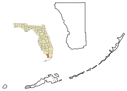 U.S. Census Bureau map showing CDP boundaries
Coordinates: 24°46′32″N 80°54′39″W / 24.77556°N 80.91083°WCoordinates: 24°46′32″N 80°54′39″W / 24.77556°N 80.91083°W Country  United States
State  Florida
County Monroe Area – Total 0.9 sq mi (2.3 km2) – Land 0.9 sq mi (2.2 km2) – Water 0 sq mi (0.1 km2) Elevation 3 ft (1 m) Population (2000) – Total 443 – Density 492.2/sq mi (192.6/km2) Time zone Eastern (EST) (UTC-5) – Summer (DST) EDT (UTC-4) ZIP code 33050 Area code(s) 305 FIPS code 12-18425[1] GNIS feature ID 1853245[2] Duck Key is a census-designated place in Monroe County, Florida, on an island of the same name in the middle Florida Keys. The CDP also includes the neighboring island of Conch Key. As of the 2000 census, the CDP had a total population of 443.
Contents
Geography
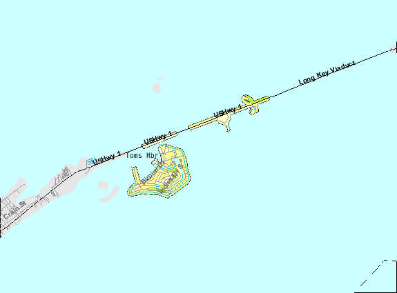
Duck Key is located oceanside of U.S. 1 (or the Overseas Highway), at approximately mile marker 61, between Conch Key and Grassy Key at 24°46′32″N 80°54′39″W / 24.775623°N 80.910972°W.[3]
According to the United States Census Bureau, the CDP has a total area of 2.4 km² (0.9 mi²). 2.2 km² (0.9 mi²) of it is land and 0.1 km² (0.1 mi²) of it (5.49%) is water.
History
The key was the site of a salt manufacturing operation in the 1820s & 1830s. Occupation of the island ceased after the Labor Day Hurricane of 1935 and did not resume until the key was connected to the highway by a causeway in 1953. J.W. Norie, in his Piloting Directions for the Gulf of Florida, The Bahama Bank & Islands (1828) states: "Duck Key - Some two miles (3 km) long, low, rocky, & covered with mangroves; some small patches of good land with a little timber. This island formerly saltworks but they were transferred latterly to Key West, owned by Mr. Howe, who is also possessor of this Key." Hawk's Cay Resort is currently located here, and the island is sometimes known by that name.[4] Noted Michigan Senate leader, Emil Lockwood,[5] retired in Duck Key, where he served in many civic and political capacities until his death in 2002.[6]
Demographics
As of the census[1] of 2000, there were 443 people, 235 households, and 141 families residing in the CDP. The population density was 198.9/km² (514.2/mi²). There were 828 housing units at an average density of 371.7/km² (961.1/mi²). The racial makeup of the CDP was 98.65% White, 0.45% African American, 0.23% Asian, and 0.68% from two or more races. Hispanic or Latino of any race were 2.93% of the population.
There were 235 households out of which 8.9% had children under the age of 18 living with them, 56.6% were married couples living together, 3.0% had a female householder with no husband present, and 39.6% were non-families. 33.2% of all households were made up of individuals and 14.9% had someone living alone who was 65 years of age or older. The average household size was 1.89 and the average family size was 2.32.
In the CDP the population was spread out with 8.8% under the age of 18, 2.3% from 18 to 24, 20.8% from 25 to 44, 40.0% from 45 to 64, and 28.2% who were 65 years of age or older. The median age was 54 years. For every 100 females there were 101.4 males. For every 100 females age 18 and over, there were 101.0 males.
The median income for a household in the CDP was $39,125, and the median income for a family was $39,708. Males had a median income of $50,341 versus $26,429 for females. The per capita income for the CDP was $29,007. About 23.4% of families and 16.6% of the population were below the poverty line, including 6.9% of those under age 18 and 15.4% of those age 65 or over.
References
- ^ a b "American FactFinder". United States Census Bureau. http://factfinder.census.gov. Retrieved 2008-01-31.
- ^ "US Board on Geographic Names". United States Geological Survey. 2007-10-25. http://geonames.usgs.gov. Retrieved 2008-01-31.
- ^ "US Gazetteer files: 2010, 2000, and 1990". United States Census Bureau. 2011-02-12. http://www.census.gov/geo/www/gazetteer/gazette.html. Retrieved 2011-04-23.
- ^ http://keys.fiu.edu/gazetteer/00000258.htm Florida Keys Gazetteer
- ^ MAN IN MOTION: Michigan's Legendary Senate Majority Leader, Emil Lockwood by Stanley C. and Marilyn H. Fedewa (Llumina/MSU Press, 2003)
- ^ http://www.duckkeyonline.com/duck_key_community/duck_key_archives/emil_lockwood.htm
Municipalities and communities of Monroe County, Florida Cities 
Village CDPs Big Coppitt Key | Big Pine Key | Cudjoe Key | Duck Key | Key Largo | North Key Largo | Stock Island | Tavernier
Unincorporated
communitiesAnglers Park | Bay Point | Chatham | Conch Key | El Chico | Garden Cove | Grayvik | Jewfish | Key Haven | Newport | Pirates Cove | Rock Harbor | Sugarloaf Shores | Summerland Key | Sunset Point | Thompson | Trail Center
Ghost towns Flamingo | Fort Jefferson | Indian Key | Perky | Pigeon Key | Pinecrest | Snake Bight
Categories:- Census-designated places in Monroe County, Florida
- Unincorporated communities in Monroe County, Florida


Wikimedia Foundation. 2010.