- Dharmapuri
-
This article is about the municipality in Tamil Nadu, India. For its namesake district, see Dharmapuri district.
Dharmapuri (தர்மபுரி) — city — Coordinates 12°07′N 78°16′E / 12.12°N 78.26°ECoordinates: 12°07′N 78°16′E / 12.12°N 78.26°E Country India State Tamil Nadu District(s) Dharmapuri Population 64,444 (2001[update]) Time zone IST (UTC+05:30) Area
• 468 metres (1,535 ft)
Website http://www.dharmapuri.tn.nic.in Dharmapuri (Tamil: தர்மபுரி) is a city and the administrative headquarters of Dharmapuri district in the state of Tamil Nadu, India. It is located 65 km north of Salem. Dharmapuri is a part of the Kongu Nadu an ancient division of Tamilakam.
The famous Hogenakkal water falls is in Dharmapuri district. Known for its mango farming, the district also has one of the best quality marble stone reserves in the world.[citation needed]
Contents
Early history
Dharampuri and the hilly region surrounding it were historically part of the ancient Chera and Kongu countries.
The earliest known chieftain who ruled Tagadur (present Dharmapuri) during the Sangam era, is Adigaman Naduman Anji, whose patronage sustained the famous poetess Avvaiyar. The next we hear in the 8th century when the northern parts of Salem District were probably under the Pallavas regime. Subsequently, we hear of the Ganga Pallavas having sway over the Western parts of the Salem District. The Western Gangas are also mentioned as having ruled Baramahal during the end of the 8th century.
In the beginning of the 9th Century, the Rashtrakutas gained power and influenced the history of the district for the next two centuries. During the period, the Cholas also rose to power in the south and Aditya-I conquered the Kongunadu in 894 A.D. During 949-950 A.D., the Cholas suffered a defeat from the Rastrakuttas whose decline started later after the death of their king Krishna-III. Subsequently, the entire area in Salem District came under the rule of the Cholas. The Gangavadi was then annexed to the Chola territory and placed in charge of an Adigaman Tagadur. The 12th century witnessed the decline of the Chola empire when the Hoysalas rose to power and routed the Cholas from Gangavadi. They are said to have captured Kolar, sacked Kotayur and over ran the western parts of Kongunadu. The Baramahal and Talaget areas apparently still remained with the Cholas. But the Adigaman seems to have practically become free and owed only nominal allegiance to the Cholas. Soundrapandia-I assisted the Yadavas in driving out the Hoysala king, Vira Someswara from the Chola territory.
The history of the 13th Century revolve itself between the Hoysalas and the Pandyas. This portion may be added after when they were attacked from the North by the Yadavas, the Hoysalas retreated towards the South in Kongunadu. It is known that Jatavarman Soundrapandian-I assisted the Yadavas in driving out the Hoysalas king, Vira Someswara, from the Chola territory. But it is doubtful whether he made himself master of the Talaghat area as there are records to show that Vira Someswara's son Vira Ramanatha later ruled the whole of Salem District and the Pandiyas were then eclipsed by the Mohammadan emissaries of the Delhi Sultanate.
The rise of Vijayanagar kingdom was seen in the 14th century. In 1365-66 A.D., Bukka-I turned his attention towards the south to overthrow the Mohammedan Sultanate of Madurai. One of these campaigns must have brought Salem District under the Vijayanagar kings. They ruled these parts till 1565 A.D when the glory of the Vijayanagar king was laid in dust by the combined armies of the Deccan Sultans on the field at Talikota Hosur Denkanikota. While Jagaderea Raya of Chennapatna ruled the Baramahal along with Mysore. Meanwhile the ascendancy of the Madurai Nayakas reached its zenith during the time of Tirumala Nayak who came to power in 1623 A.D. and this tract was placed in charge of Poligars owing allegiance to him. Ramachandra Nayaka, one of his poligars was in charge of Talaimalai a hill overlooking the Cauvery in the south Namakkal taluk. The Namakkal Fort is said to have been built by them. The Gathi Mudaliars were in charge of the most dangerously exposed province of the Nayak Kingdom with Kaveripuram on the right bank of the Cauvery as their strategic capital commencing one of the principal passes to the Mysore plateau. The centre of then power seems, however to have been Taramangalam where they built a grand edifice of a temple. It is said that their domination extended as far as Talaivasal to the east, Dharapuram in Coimbatore District in the south. The forts of greatest strategic importance held by the Gathi Mudaliars were Omalur and Attur.
Several places in Coimbatore were taken by Kantirave Narasa Raja of Srirangapatinam from Gathi Mudaliars in 1611 A.D. After 11 years, he seized Baramahal including Viralahadradurg, Pennagaram, Dharmapuri and Denkanikotta in 1654 A.D., he took over Hosur from Chandra Sankar Dodda Devaraju the king of Mysore wrested Omalur from the Gathi Mudaliars and thus erased them out of political scene. The aggression of Marattas, however checked the power of the Mysore Kings. For a time Baramahal and Talaghat passed into the hands of Marattas. In 1688-89 A.D., Chikka Deva Raya king of Mysore felt strong enough once again to invade Baramahal and wrested Dharmapuri, Manukonda, Omalur Paramathi, Kaveripatinam and Attur were also retrieved by Chika Deva Raya and the whole district of Salem came under his control before his death in 1704 A.D. Meanwhile Abdul Nabikhan of Nawab of Cuddapah extended his possession towards South and by 1714 A.D., he made himself master of the Baramahal.
By about 1750 A.D., Hyder Ali was in power in Mysore Baramahal came under his sway in 1760 A.D. By 1767 A.D., the British Government at Madras planned an attack on Hyder Ali and seized Kaveripattinam without serious opposition. Krishnagiri was then besieged. Meanwhile, reinforcement was brought by Hyder Ali and they drove away the British. Thus, Kaveripattinam was recaptured. Some months later the British made another invasion on the Baramahal. Further, South Dharmapuri, Salem, Attur, Sendamangalam and Namakkal were surrendered to the British without serious difficulties. The victory, however, was short-lived because Hyder Ali soon recaptured Dharmapuri, Denkanikota, Omalur, Salem and Namakkal. During the period of second Mysore war, Salem District was in the hands of Hyder Ali.
Tippu Sultan succeeded Hyder Ali and proved to be a formidable power. The British made an alliance with the Marattas and the Nizam and started the third Mysore war in 1790 A.D., in order to curb the power of Tippu Sultan. A wing of the British forces stationed itself fully reinforced at Kaveripattinam. Even though Tippu Sultan rushed to this spot with his full force, he could not dislodge the British. A number of alternations took place between the commanding forces in the Baramahal area. In 1791, Hosur, Anjetti, Nilgiri and Ratnagiri came under the British Royakotta and many other small forts fell without much resistance. In 1791 Tippu sent a force from the South along the Tippu pass. In the battle at Pennagaram they surrendered to the British. In 1792 A.D., a peace treaty was signed between Tippu and English. According to this, a half of the dominion of Tippu was taken away. The whole of Salem District except the Balaghat and a portion of Hosur came into the hands of the British. The first British Collector had is headquarters at Krishnagiri on strategic consideration.
The last Mysore war in 1799 added up several places in Hosur Taluk like Nilgiri, Anjetti, Durgam, Ratnagiri and Kelamangalam which were recaptured by British. After the fall of Srirangapattinam in which Tippu Sultan lost his life, the Balaghat area was also added to Salem District.
District formation
The present Dharmapuri district was then a part of the Salem district. During the British rule in the country and even till 1947 Dharmapuri was one of the Taluks of Salem District. The Dharmapuri district was formed as a separate district on 02/10/1965 with its headquarters at Dharmapuri.
Geography
Dharmapuri is situated in the northwestern corner of Tamil Nadu and is bounded by Tiruvannamalai and Viluppuram districts on the east, Salem district on the South, Krishnagiri district on the north and the river Kaveri on the west. It is located between latitudes N 11 47’ and 12 33’ and longitudes E 77 02’ and 78 40’. The total geographical area of Dharmapuri district is 4497.77 km² which is 3.46% of Tamil Nadu. Dharmapuri was called Thahadoor when King Adhiyaman ruled the Kongu Nadu.
Climate
The climate is generally warm. The hottest period of the year is between the months of March to May, reaching a maximum temperature of up to 32°C in April. The temperatures drop in December and the low temperatures continue up to February, touching a minimum of 14°C in January. The district has an average annual rainfall of 895.56 mm.The tropical forests here generally have short shrubs and thorned-plants.[citation needed]
Town
Dharmapuri urban area is situated in the centre of Dharmapuri district. It has nine cinema theatres, and many hotels and restaurants also lot of very tasty and delicious foods restaurents available through NH7, the restaurents are calles as Dhaba hotels.
Road connectivity
Dharmapuri is well connected by the major National Highway - NH 7 : (North-south Corridor National Highway System) Varanasi - Bangalore – Dharmapuri - Salem - Dindigul – Madurai – Tirunelveli – Kanyakumari. It is officially listed as running over 2,369 km (1,472 mi) and the longest national highway in India. Recently it was extended up to Kashmir.
Bus facility
It has two bus stands - one for rural/urban places of dharmapuri district and another for all major parts of Tamil Nadu like Chennai and Coimbatore and buses to other state destinations (like Banglore, Tirupati) area also operated.
Rail connectivity
Dharmapuri is connected with South Western railways. Station code is DPJ. In recent Railway budget 2011, Railway minister Mamata announced new DEMU (Diesel Electric Multiple Unit) train service between Dharmapuri-Bangalore. Apart from this there is a long pending demand of the people of Dharmapuri to establish a new railway link of 27 km between Dharmapuri and Morapur.
List of trains that pass via dharmapuri is given below:
Train Number Train Name Source Station Destination Station
06234 BANGALORE EXP RAMESWARAM (RMM) MYSORE JN (MYS)
12678 BANGALORE EXP ERANAKULAM JN (ERS) BANGALORE CY JN (SBC)
11013 COIMBATORE EXP LOKMANYATILAK T (LTT) COIMBATORE JN (CBE)
12677 ERNAKULAM EXP BANGALORE CY JN (SBC) ERANAKULAM JN (ERS)
06233 HUBLI EXPRESS MYSORE JN (MYS) RAMESWARAM (RMM)
12257 KOCHUVELI GR YESVANTPUR JN (YPR) KOCHUVELI (KCVL)
12647 KONGU EXPRESS COIMBATORE JN (CBE) H NIZAMUDDIN (NZM)
12648 KONGU EXPRESS H NIZAMUDDIN (NZM) COIMBATORE JN (CBE)
11014 LOKMANYA TT EXP COIMBATORE JN (CBE) LOKMANYATILAK T (LTT)
16232 MAILADUTURAI EXP MYSORE JN (MYS) MAYILADUTURAI J (MV)
16731 MYSORE EXP TUTICORIN (TN) MYSORE JN (MYS)
16231 MYSORE EXPRESS MAYILADUTURAI J (MV) MYSORE JN (MYS)
12255 PUDUCHERRY EXP YESVANTPUR JN (YPR) PONDICHERRY (PDY)
16732 TUTICORIN EXP MYSORE JN (MYS) TUTICORIN (TN)
16528 YESVANTPUR EXP KANNUR (CAN) YESVANTPUR JN (YPR)
12256 YESVANTPUR EXP PONDICHERRY (PDY) YESVANTPUR JN (YPR)
12258 YESVANTPUR EXP KOCHUVELI (KCVL) YESVANTPUR JN (YPR)
16527 Ypr Cannanore E YESVANTPUR JN (YPR) KANNUR (CAN)
Economy
Horticulture
Dharmapuri district forms a major horticultural belt in the state. The soil type ranges from black to mixed loam. Red sandy soils are seen in Harur Taluk, black and loam soil are found in Dharmapuri Taluk. Generally the soil is low in nitrogen and phosphate content with no marked variation between Taluks. As the area is drought–prone it has become essential to switch over to cultivation of drought tolerant perennial fruit crops in this district.
Many types of fruit and all the vegetables are cultivated, with mango being the main crop. The district accounts for nearly one-third of the state's total mango cultivation area and nearly one-half of the mango yield. Nearly 80% of the produce is of the Thotapuri variety.
The district has the second highest area of tomato cultivation in the state, accounting for 22% of the total, and world class tamarind is also an important crop. It's also famous for manioc/cassava/arrow root, flowers, ground nut, sugarcane, coconut.
Mineral resources
Dharmapuri district has sizeable reserves of granite. High quality black granite is quarried in Pennagaram, Harur and Palacode. Quartz is found at the villages of Kendiganapalli in Pennagaram Taluk, Velampatti in Harur taluk and Pethathampatti in Pappireddipatti Taluk.
Another high value mineral available here is molybdenum, which is to be found in Harur.
Fisheries
Dharmapuri being an inland district, fishing is restricted to inland only here. Main varieties of fish available are katla, rogu, mirgal, and common carp.
Demographics
As of 2001[update] India census,[1] Dharmapuri had a population of 64,444. Males constitute 51% of the population and females 49%. Dharmapuri has an average literacy rate of 74%, higher than the national average of 59.5%: male literacy is 79% and, female literacy is 68%. In Dharmapuri, 11% of the population is under 6 years of age. Tamil is the Official language, but Telugu and Kannada is spoken among several communities in northern part of the district.
Education
Main article: List of educational institutions in DharmapuriThe district has a medical college, five engineering colleges, six nursing colleges, twelve arts colleges and many polytechnic colleges. There are many schools.
Tourist places
Hogenakkal Falls
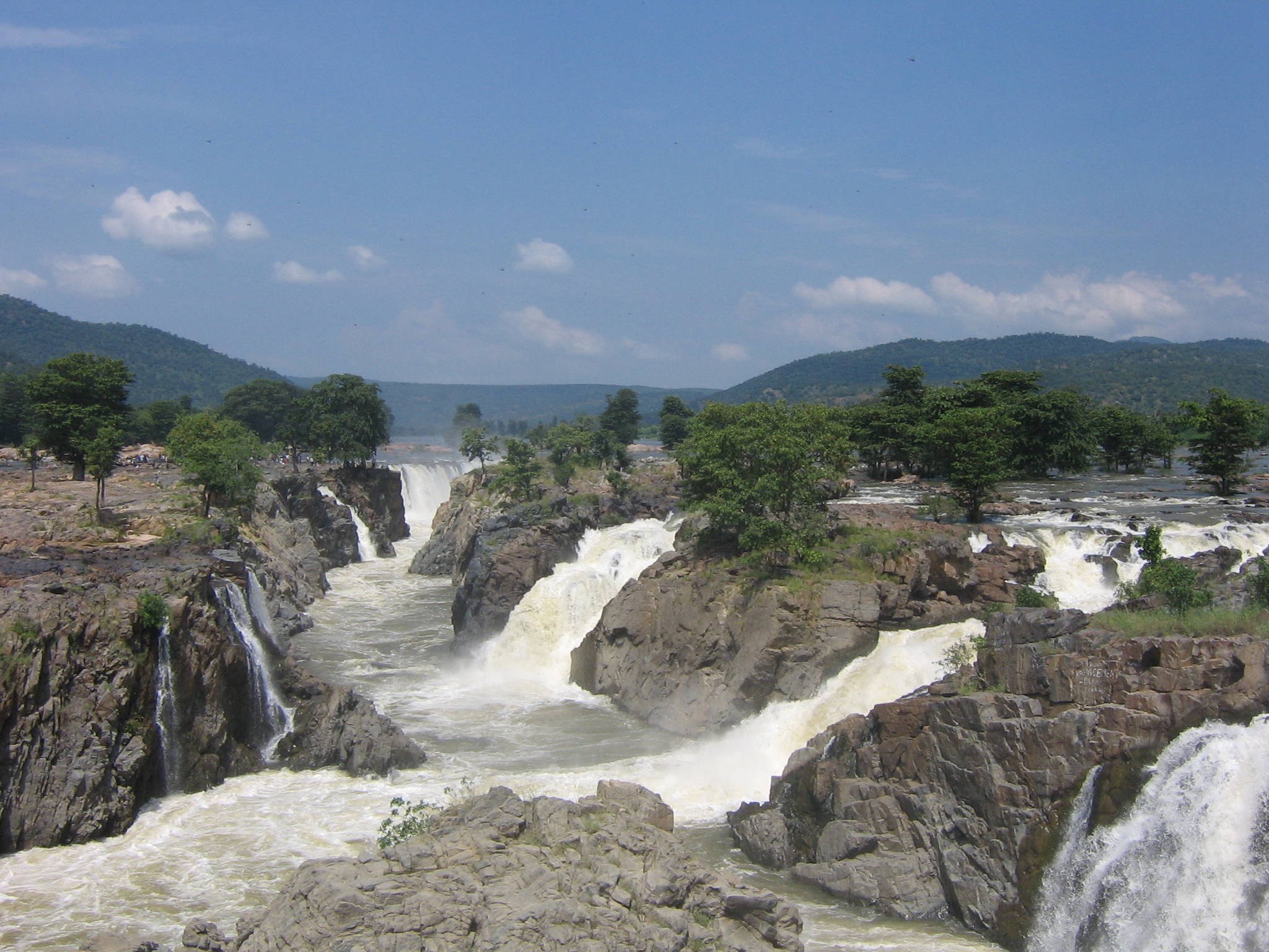
Main article: Hogenakkal Falls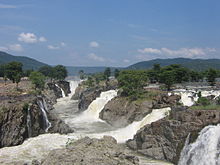 Hogenakal Waterfall on Kaveri river, Dharmapuri district
Hogenakal Falls is located at the border of Karnataka and Tamil Nadu, around 46 km from Dharmapuri. In Hogenakal, the Kaveri River enters Tamil Nadu as a big river with gushing water. The name 'Hogenakal' is derived from Kannada means Smoky Rocks. When the river falls on the rock below, the gushing force of water causes a smoke-like mist, leading to the origin of the name. At Hogenakal, the water spreads for miles around and cruising on country-made dinghies (Parisal) is possible.
Hogenakal is considered the Grand Canyon of India in terms of the unique landscape and the wild Kaveri river flowing there for ages. It is also sometimes referred to as the Niagara Falls of India.
Theerthamalai temple
Theerthamalai is a sacred place in Harur taluk. The temple is located at the top of a hillock. Chola and Vijayanagara kings donated liberally to this temple. A lot of devotees attend the temple during the Maha Shivarathiri. It is believed that Lord Rama created the waterfall to do abhishek for Lord Shiva, after waiting for a long time for Hanuman to bring water.
Sir Thomas Munro Pillar, Dharmapuri
This pillar was erected by the British India's Government of Madras to mark the association of Dharmapuri with SIR THOMAS MUNRO who lived here from April 1792 to March 1799 as Assistant to the Superintendent of Revenue in the BARAMAHAL. His house and his favourite garden where few yards away from this place.near at vel milk depot
Hanumanthathirtham
This place is situated on the bank of Pennaiyar at a distance of 10 km from Uthangarai and traditionally associated with Tirtamalai. It is believed that Hanuman was instructed by Lord Rama to bring water, but after waiting for a long time, Rama created a waterfalls, Hanuman was said to have thrown down the vessel in which he brought the holy water and this spilled water is believed to be the "Hanumantatirtham".
Adhiyamankottam
The capital of Adhiyamans, ancient rulers of Thahadoor, was Adhiyamankottam which is situated on the Salem-Dharmapuri road, 7 km from Dharmapuri. The ruins of the roughly oval shaped fort is still there. The Chenraya Perumal temple there is a protected monument and is thought to have been constructed both by the King Krishna Devaraya and the Hoysala kings. There is a mandapam which leads to the sanctum sanctorum. There are paintings in the ceiling depicting scenes from the Mahabharata, Viswarupa darshan of Lord Krishna and some scenes from the Ramayana. All the paintings belong to the 13th century.
Kottai Kovil
This is one of the temples built for Lord Shiva. It is located on the northern side of Dharmapuri. It has been renovated and is maintained by the government and people of Dharmapuri. There a rare sculptures and paintings contained in it. The main speciality of this temple is the 'Hanging pillar'. There is also a legend that there was a secret passage that connects this temple to Adhiyamankottai.
Subramanya Siva Memorial
Subramanya Siva was born on 19 September 1884 in Vathalagundu, Madhurai. He was a revolutionary independence fighter who worked closely with other freedom fighters, such as V.O Chidambaram Pillai and Subramanya Bharathi, and inspired many young men to join the freedom movement. He was the first political prisoner of the Madras presidency and described his jail experiences in a book, Jail Life. He also published Gnana Bhanu, a collection of poems. He was an admirer of the philosopher, Swami Vivekanandha and his religious master Ramakrishna Paramhamsa. Siva disagreed on many things with Gandhian Philosophy. He believed in using violent methods where constructional methods had failed. Siva died on 23 July 1925.
A monument has been built in memory of Siva in the government school name after him at Pauparapatti, Pennagaram Taluk.
C.S.I Zion Church
C.S.I[clarification needed] Zion Church is one of the C.S.I churches located in Dharmapuri district. It is the head of all the other C.S.I churches in Dharmapuri district. The youths of this church along with other church members are doing many social activities including helping poor people, visiting leprosy people & providing them old usable clothes, celebrating festivals with orphans, etc.
Sacred Heart cathedral
The Sacred Heart cathedral is the seat of the Roman Catholic Diocese of Dharmapuri.
Mount Carmel church
Mount Carmel church is situated in B. Pallipatty, which is known for its Grotto festival. This is a three day feast celebrated on the second Friday after Easter and is attended by more than a lakh (c. 100,000) people seeking to receive the blessing of Our Lady of Lourdes.
Cinema theatres
- Sri Hari A/C DTS
- GM Theatre A/C DTS
- Sri Ganesha DTS
- DNC-DTS
- Madheswara DTS
- Santhosh DTS
- Anandh DTS
- AV Theatre
- Lakshmi Theatre
Politics
Dharmapuri assembly constituency is part of Dharmapuri (Lok Sabha constituency).[2]
It consists of following assembly segments: Palacodu, Pennagaram, Dharmapuri, Pappireddippatti, Harur (SC)
Judges
- M.S.Singaravel Chettiar, Jury - District and sessions court,Salem District[During 1950's],Honorary Magistrate - Dharmapuri District Court,Dharmapuri
References
- ^ "Census of India 2001: Data from the 2001 Census, including cities, villages and towns (Provisional)". Census Commission of India. Archived from the original on 2004-06-16. http://web.archive.org/web/20040616075334/http://www.censusindia.net/results/town.php?stad=A&state5=999. Retrieved 2008-11-01.
- ^ "List of Parliamentary and Assembly Constituencies". Tamil Nadu. Election Commission of India. http://archive.eci.gov.in/se2001/background/S22/TN_ACPC.pdf. Retrieved 2008-10-09.
See also
Municipalities of Tamil Nadu Municipal
CorporationsChennai · Coimbatore · Erode · Madurai · Salem · Tiruchirappalli · Tirunelveli · Tirupur · Tuticorin · Vellore
Municipalities Alandur · Ambasamudram · Ambattur · Ambur · Anaiyur · Anakaputhur · Arakkonam · Arani · Aranthangi · Arcot · Ariyalur · Aruppukkottai · Attur · Avadi · Avaniyapuram · Bhavani · Bodinayakanur · Chengalpattu · Chidambaram · Chinnamanur · Colachel · Coonoor · Cuddalore · Cumbum · Devakottai · Dharapadavedu · Dharapuram · Dharmapuri · Dindigul · Edappadi · Gobichettipalayam · Goundampalayam · Gudalur: (Coimbatore district), (Nilgiris district), (Theni district) · Gudiyatham · Hosur · Inam Karur · Jayankondam · Jolarpet · Kadayanallur · Kallakurichi · Kancheepuram · Karaikudi · Karur · Kasipalayam (E) · Kattivakkam · Kayalpattinam · Keelakarai · Kodaikanal · Komarapalayam · Koothanallur · Kovilpatti · Krishnagiri · Kulithalai · Kumbakonam · Kuniyamuthur · Kurichi · Kuzhithurai · Madhavaram · Maduranthakam · Maduravoyal · Manali · Manapparai · Mannargudi · Maraimalainagar · Mayiladuthurai · Melur · Mettupalayam · Mettur · Nagapattinam · Nagercoil · Nallur: (Kanniyakumari district), (Tirunelveli district) · Namakkal · Narasingapuram · Nellikuppam · Nelliyalam · Padmanabhapuram · Palani · Palladam · Pallavapuram · Pallipalayam · Pammal · Panruti · Paramakudi · Pattukkottai · Perambalur · Periyakulam · Periyasemur · Pernampattu · Pollachi · Poonamallee · Pudukkottai · Puliyankudi · Punjaipuliampatti · Puzhuthivakkam · Rajapalayam · Ramanathapuram · Rameswaram · Ranipet · Rasipuram · Sankarankoil · Sathuvachari · Sathyamangalam · Sattur · Sengottai · Sirkazhi · Sivagangai · Sivakasi · Srivilliputhur · Surampatti · Tambaram · Tenkasi · Thanjavur · Thanthoni · Theni Allinagaram · Tirumangalam · Thiruparankundram · Thiruthangal · Thiruthani · Thiruthuraipoondi · Thiruvannamalai · Thiruvathipuram · Thiruverkadu · Thuraiyur · Thuvakudi · Tindivanam · Tiruchengode · Tiruppattur · Tiruvallur · Tiruvarur · Tiruvottiyur · Udhagamandalam · Udumalaipettai · Usilampatti · Valasaravakkam · Valparai · Vandavasi · Vaniyambadi · Vedaranyam · Veerappanchatram · Velampalayam · Vellakoil · Vikramasingapuram · Villupuram · Virudhachalam · Virudhunagar · Walajapet
Nagar
PanchayatsCategories:- Cities and towns in Dharmapuri district


Wikimedia Foundation. 2010.