- Mount Tabor
-
For other uses, see Mount Tabor (disambiguation).
Mount Tabor 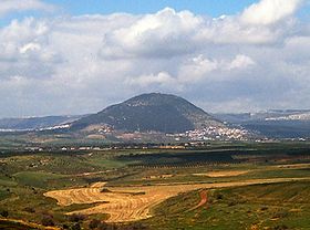
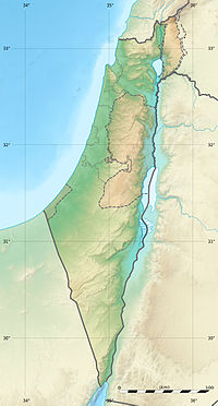
Elevation 575 m (1,886 ft) Location Lower Galilee, Israel Coordinates 32°41′13.61″N 35°23′25.38″E / 32.6871139°N 35.3903833°ECoordinates: 32°41′13.61″N 35°23′25.38″E / 32.6871139°N 35.3903833°E Mount Tabor (Hebrew: הַר תָּבוֹר, Arabic: {جبل الطور }, Greek: Όρος Θαβώρ) is located in Lower Galilee, at the eastern end of the Jezreel Valley, 11 miles (18 km) west of the Sea of Galilee, in Israel. It was the site of the battle between Barak and the army of Jabin, commanded by Sisera during the leadership of the Israelite judge Deborah in the mid 14th century BCE. It is believed by many Christians to be the site of the Transfiguration of Jesus.[1] It is also known as Har Tavor, Itabyrium, Jebel et-Tur, and the Mount of Transfiguration.
The Jewish village Kfar Tavor is located at its base, to the east, as well as two Arab communities: Shibli-Umm al-Ghanam (south and east) and Daburiyya (northwest).
Contents
Geology
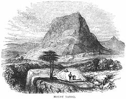
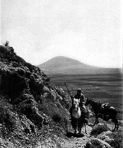
The mountain is a monadnock; an isolated hill or small mountain rising abruptly from gently sloping or level surrounding land, and is not volcanic. In spite of its proximity to the Nazareth mountains, it constitutes a separate geological form.
History
At the bottom of the mountain was an important roads junction: Via Maris passed there from the Jezreel Valley northward towards Damascus. Its location on the road junction and its bulgy formation above its environment gave mount Tabor a strategic value and wars were conducted in its area in different periods in history.
The period of Joshua and Judges
The mountain is mentioned for the first time in the Hebrew Bible, in Joshua 19:22, as border of three tribes: Zebulun, Issachar and Naphtali. The mountain's importance stems from its strategic control of the junction of the Galilee's north-south route with the east-west highway of the Jezreel Valley. Deborah the Jewish prophetess summoned Barak of the tribe of Naphtali and gave him God's command, "Go and draw toward mount Tabor, and take with thee ten thousand men of the children of Naphtali and of the children of Zebulun" (Judges 4:6). Descending from the mountain, the Israelites attacked and vanquished Sisera and the Canaanites.
The Second Temple period
In the days of Second Temple, Mount Tabor was one of the mountain peaks on which it was the customed to light beacons in order to inform the northern villages of Jewish holy days and of beginnings of new months.
During a Hasmonean rebellion against the Roman Aulus Gabinius, Alexander of Judaea and his army of 31,000 Judeans, was defeated in battle near Mount Tabor. As many as 10,000 Jewish fighters were killed in the battle; Alexander himself was captured and executed.
In 66 AD during the First Jewish-Roman War, the Galilean Jews retrenched on the mountain under the command of Josephus Flavius, whence they defended against the Roman assault.
Mount Tabor was one of the 19 cities which the rebels in Galilee fortified, under the command of Yosef Ben Matityahu. According to what is written in the book "The Wars of the Jews", Vespasian sent an army of 600 riders, under the command of Platsidus, who fought the rebels. Platsidus understood that he could not reach the top of the steep mountain with his forces, and therefore called the fortified rebels to walk down the mountain. A group of Jewish rebels descended from the mountain, supposedly, in order to negotiate with Platsidus, but they attacked him. The Roman forces initially retreated, but while they were in the valley, they returned towards the mountain, attacked the Jewish rebels, killed many of them, and blocked the road for the remaining rebels who tried to flee back to the top of the mountain. Many of the Jewish rebels left Mount Tabor and returned to Jerusalem. The rest of the fortified rebels in the fortress on the mountain surrendered after the water, which they possessed, ran out. They then handed over the mountain to Platsidus.[2]
After the destruction of the second temple the Jewish settlement in Mount Tabor was renewed.
The Byzantine period and the middle ages
Due to the importance of Mount Tabor in the Christian tradition, it became the focus of pilgrimage which began during the 4th century. According to descriptions of the pilgrims, during the 6th century there were three churches on the top of the mountain, and during the 8th century there were four churches and a monastery. During the Arab period, in 947, a battle occurred in mount Tabor between different streams on the control of the land of Israel on behalf of the Abbasid Caliphate.
During the period of the Crusades, the mountain changed hands many times between Muslims and Christians. In 1099 the crusaders fortified the area of the church and the monastery which was on the peak of the mountain, in order to protect the pilgrims from the Muslims attacks. In 1212 the mountain was occupied by the Ayyubid Sultan Al-Adil I which established on it a larger fortress but in 1229 it was occupied again by the Christians. In 1263 the Mamluk ruler Baibars occupied the fortress and ruined the buildings on the mountain.
Modern times
In 1799, during the time of Napoleon Bonaparte's expedition to the land of Israel, in the valley between mount Tabor and the Moreh hill was held a battle in which a French force of about 3,000 soldiers in the command of Napoleon and general Jean Baptiste Kléber against a Mamluk force of about 20,000 soldiers.
At the end of the 19th century and at the beginning the 20th century the Bedouin tribe Arab-A Tzabiach settled in the mountain. The tribe members were employed by different members of the neighbouring Jewish settlements Kfar Tavor and Ilaniya but had disputed with them due to thefts.
During the 1948 Arab–Israeli War members from the Arab-A Tzabiach tribe participated in the army of the Arab Liberation Army of Fawzi al-Qawuqji and amongst others killed seven members of the village Beit Keshet. In the start of May 1948 the Golani Brigade occupied Mount Tabor. Most members of the tribe were forced out to Syria and to the Kingdom of Jordan, except for one stream of the tribe, the clan of Shibli, which its members collaborated with the members of the Haganah forces and stayed in Israel. After the war their village was established, Arab Al-Shibli which is nowadays part of the village Shibli-Umm al-Ghanam.
Place of Christian pilgrimage
According to one ancient Christian tradition, Mount Tabor is the site of the Transfiguration of Christ, during which Jesus began to radiate light and was seen conversing with Moses and Elijah. The scene is in the Synoptic Gospels, as well as alluded to in 2Peter 1:16-18, but neither account identifies the "high mountain" of the scene by name. The earliest identification of the Mount of Transfiguration as Tabor is by Origen in the 3rd century. It is also mentioned by St. Cyril of Jerusalem and St. Jerome in the 4th century.[3] It is later mentioned in the 5th century Transitus Beatae Mariae Virginis. Mount Hermon is an alternative site according to tradition.[citation needed]
In 1101, when Crusaders controlled the area, the Benedictine monks rebuilt a ruined basilica and erected a fortified abbey.[4]
Currently, on the mountaintop there are two Christian monasteries, divided into Eastern Orthodox (northeast) and Roman Catholic (southeast) areas.
Church of the Transfiguration
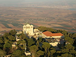
Main article: Church of the TransfigurationBetween 1919 until 1924 an impressive Roman Catholic church of the Franciscan order named "Church of the Transfiguration" was built on the peak of Mount Tabor. The architect who designed the church, as well as other churches in Israel, was Antonio Barluzzi. The church was built upon the ruins of a Byzantine church from the fifth or sixth century and a Crusader church from the 12th century, which was built in honor of Tancred, Prince of Galilee. The friars of the church live next to the church in a monastery established in 1873.
The church was built from three Naves which are separated by two rows of columns holding the arches. In the two bell towers on either side of the entrance to the building, there are two Chapels. The northern chapel is dedicated to Moses and it contains an image of him getting the Tablets of Stone on Mount Sinai, and the southern chapel is dedicated to Elijah the prophet and it contains an image of him in his confrontaition with the Ba'al prophets on Mount Carmel.
On the upper part of the church, above the altar, there is a mosaic which depicts the Transfiguration, and on the Transfiguration holiday on August 6, it is illuminated by the sun beams which are returned from a glass plate located on the church's floor.
A rock near the entrance of the church has an engraving in ancient Greek and beside it there is an engraving of a cross. Nearby there are the remains of the monastery of San Salvatore (Monastère St Salvador) which was established by the Order of Saint Benedict in 1101.
The Eastern Orthodox sanctuary
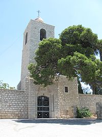
On the northeast side of the Church of the Transfiguration there is the more modest Orthodox Church which was built in 1862 with funds from Romania. The church was dedicated to Elijah the prophet and was the first religious structure built by Romanian Christians in the Holy Land.
On the northwest side of the church there is a cave named after Melchizedek the King of Salem. According to the Christian tradition, this cave was the place where Abraham met the king of Salem. The cave was known to pilgrims and Christians during the Middle Ages. With an increase in pilgrimages, the church is now open to the public (though it closes for a few hours at noon).
An All-Night Vigil is held at the Eastern Orthodox church every year on the Orthodox Feast of the Transfiguration (August 19, which is August 6 according to the Julian Calendar).
Vegetation
Mount Tabor was entirely covered with vegetation typical of northern Palestine until the reign of the Ottoman Empire, during which period most of the trees were felled. As part of the Jewish National Fund's efforts to recreate the landscapes of the country, the area was reforested with trees which are similar to its original vegetation. Today, most of Mount Tabor is covered with pine trees.
Tourism
Accessibility
Mount Tabor is located off of Highway 65, and its summit is accessible by personal vehicle via Shibli's access road. The peak itself is also traversed by the Israel National Trail.
Nowadays the reaching the top of the mountain itself does not demand great effort, but before circa 1,600 years ago one had to walk up no less than 4,340 stairs in order to arrive at the peak of the mountain.
Walking paths
There are two paths: the long track, which starts from the Bedouin village Shibli, which length is about five kilometers long and a short nature track of about 2.5 kilometers at the summit.
The track which surrounds the mountain passes in well-developed Mediterranean woodlands. the color marking alternates to green at the eastern part of the track. Behind the monastery its possible to see remnants from the First Jewish–Roman War. In the path there is a view of the Jezreel Valley, Mount Gilboa, Samaria mountains, Mount Carmel, the Golan Heights, Gilead, the Lower Galilee and the Upper Galilee. On days with good visibility one could also see the Mount Hermon.
Israel National Trail goes up the mountain from mount Tabor the Gazit junction and the Shibli village, surrounding the summit and descends across the Arab village of Daburiyya towards the Nazareth mountains.
Activities on Mount Tabor
- In April each year, the regional council of Lower Galilee holds a marathon race around Mount Tabor in memory of Yitzhak Sadeh, the first commander of the Palmach and one of the founders of the Israel Defense Forces at the time of the State of Israel's independence.
- By obtaining a game permit issued by the Ministry of the Interior, hunting of small animals is allowed in certain designated seasons.
- The churches located on the mountain allow visits at specific hours. (Modest attire required).
- Approximately three quarters of the way up the mountain, a path circles it entirely and is accessible for private vehicles as well (four-wheel drive advised).
- The mountain serves as one of Israel's preferred locales for hang gliding.
References
- ^ Location of the Transfiguration in Catholic Encyclopedia
- ^ Wars 4.54-61
- ^ Meistermann, Barnabas (1912), "Transfiguration", The Catholic Encyclopedia, XV, New York: Robert Appleton Company, http://www.newadvent.org/cathen/15019a.htm, retrieved 2007-08-15
- ^
 "Mount Thabor". Catholic Encyclopedia. New York: Robert Appleton Company. 1913.
National parks of Israel Jerusalem District Bayt 'Itab · Canada Park · Castel · City of David National Park1 · Ein Hemed · Judaean Mountains · Tomb of Samuel1North District Achziv · Bar'am National Park · Beit Alfa Synagogue · Beit She'an · Beit She'arim · Belvoir Fortress · Capernaum · Chorazin · Gan HaShlosha · Hamat Gader · Hamat Tiberias · Harod Spring · Hermon National Park1 · Hexagons pool · Horns of Hattin · Hurshat Tal · Hurvat Minia · Kursi1 · Montfort Castle · Mount Arbel · Mount Tabor · Nimrod Fortress1 · Rosh HaNikra · Sde Amudim · Sussita · Tel Hazor · Tel Kedesh · Tel Megiddo · Tzalmon Stream · Tzippori · Yehi'am Fortress · Hula ValleyHaifa District Central District Alexander stream · Arsuf · Hof HaSharon · Mazor Mausoleum · Migdal Afek · Palmachim beach · Rubin Stream · Sidna Ali · Tel Afek · Tel Gezer · Tzur Natan park · Yarkon National ParkSouthern District Ashkelon National Park · Avdat · Besor Stream · Beit Guvrin National Park · Ein Avdat · Ein Gedi · Eshkol Park · Mamshit · Masada · Monument to the Negev Brigade · Nitzana · Semekh caves · Shivta · Tel Arad · Tel Be'er Sheva · Tel Lachish · Tel ZafitJudea and Samaria Area 1 Located in the Israeli-occupied territories Nature reserves of Israel
Northern District Ein Afek · Akhziv Islands · Alonei Yitzhak · Alonei Abba · Amud Stream · Nahal Ayun · Balfouria · Bitan Aharon · Nahal Betzet · Nahal Dishon · Dor Beach and Ma'agan Michael Islands · Ein Avazim · Ein Elah · Ein Nymphit · Ein Te'oh · Ein Yehuda · Nahal Gamal · Gamla nature reserve† · Snir Stream · Hermon nature reserve† · Nahal Hermon† · Hula Valley · Hurshat Tal · Hurshat Zakum · Kerem Ben Zimra · Nahal Kziv · Mount Arbel · Mount Carmel · Mount Gilboa · Mount Meron · Mount Tabor · Pa'ar Cave · Rosh HaNikra · Shamir-Nahal Rachum · Shimron · Nahal Taninim · Tel Anafa · Nahal Tavor · Tel Dan · Tel Shikmona · Nahal YehiamCentral District Adullam · Ashdod Nitzanim Sand Dune Park · Bnei Zion · Avshalom Cave · Ein Hemed · HaMasrek Reserve · Neot Kedumim · Nahal Poleg · Nahal Sorek · Tel Yitzhak · Te'omim Cave · UdimSouthern District Eilat Region Coral Beach Nature Reserve · Timna valley · Yotvata Hai-Bar† Located in the Israeli-occupied territoriesCategories:- Christianity in Israel
- Hebrew Bible mountains
- Mountains of Israel
- National parks of Israel
- New Testament places
- Basilica churches in Asia
Wikimedia Foundation. 2010.

