- HaMakhtesh HaGadol
-
Coordinates: 30°55′30″N 34°58′52″E / 30.925°N 34.98111°E
HaMakhtesh HaGadol (המכתש הגדול , מכתש חֲתִירָה) The Big Makhtesh National Parks and Nature Reserve 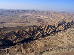 Eastern part of Makhtesh Gadol from the air
Country Israel District South Municipality Israel Nature and Parks Authority Coordinates 30°55′30″N 34°58′52″E / 30.925°N 34.98111°E Length 12 km (7 mi) Width 5 km (3 mi) Area (60) km2 (23 sq mi) 
HaMakhtesh HaGadol (Hebrew: הַמַּכְתֵּשׁ הַגָּדוֹל, lit. The Big Crater) is a makhtesh, a geological erosional landform of Israel's Negev desert.
A makhtesh has steep walls of resistant rock surrounding a deep closed valley. One of five makhteshim in Israel and seven in the world, HaMakhtesh HaGadol is the second largest, being exceptional in that it is drained by one river, Nahal Hatira. Makatesh Gadol was discovered and named before Makhtesh Ramon which is the largest Makhtesh in Israel.
 Nature reserves of Israel
Northern District Ein Afek · Akhziv Islands · Alonei Yitzhak · Alonei Abba · Amud Stream · Nahal Ayun · Balfouria · Bitan Aharon · Nahal Betzet · Nahal Dishon · Dor Beach and Ma'agan Michael Islands · Ein Avazim · Ein Elah · Ein Nymphit · Ein Te'oh · Ein Yehuda · Nahal Gamal · Gamla nature reserve† · Snir Stream · Hermon nature reserve† · Nahal Hermon† · Hula Valley · Hurshat Tal · Hurshat Zakum · Kerem Ben Zimra · Nahal Kziv · Mount Arbel · Mount Carmel · Mount Gilboa · Mount Meron · Mount Tabor · Pa'ar Cave · Rosh HaNikra · Shamir-Nahal Rachum · Shimron · Nahal Taninim · Tel Anafa · Nahal Tavor · Tel Dan · Tel Shikmona · Nahal YehiamCentral District Adullam · Ashdod Nitzanim Sand Dune Park · Bnei Zion · Avshalom Cave · Ein Hemed · HaMasrek Reserve · Neot Kedumim · Nahal Poleg · Nahal Sorek · Tel Yitzhak · Te'omim Cave · UdimSouthern District Eilat Region † Located in the Israeli-occupied territories Categories:- Erosion landforms
- Landforms of Israel
- Levant
- Landforms of the Middle East
- Nature reserves in Israel
- Regional geology stubs


Wikimedia Foundation. 2010.