- Mount Gilboa
-
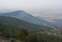

Mount Gilboa (Hebrew: הר הגלבוע, Har haGilboa'; Arabic: جبال فقوعة Jabal Faqu'a) is a ridge above the Jezreel Valley in northern Israel. The formation extends from southeast to northwest, bordering the highlands of the West Bank and the Beit She'an valley. The Green Line between Israel and the West Bank runs south and west of the ridge. The Gilboa range is also the setting in the Books of Samuel portraying Saul, Jonathan and David.[1]
Contents
Kibbutzim
The mountain has two religious kibbutzim, Ma'ale Gilboa and Meirav, named after one of Saul's daughters, as well as a drug rehabilitation centre called Malkishua, most likely after one of King Saul's sons, Malchi-shua. Ma'ale Gilboa has in it a yeshiva (Talmudical school), Yeshivat Ma'ale Gilboa. Municipal services are mainly administered by the Gilboa Regional Council, although two villages are part of the Beit She'an Valley Regional Council.[citation needed]
The Israeli government had proposed a new community on the mountain: Mikhal, named after Saul's other daughter Michal. However, environmentalists and other residents had been vehement in their opposition to this project, fearing that Mikhal would destroy more green space and threaten certain irises which are unique to this area. Others in opposition questioned the need for an additional village, since the existing villages were themselves trying to attract new residents and expand.[citation needed]
Vegetation
Every year, in early spring, the Iris haynei (Irus Ha-Gilboa) flower grows on the mountain, and visitors from all over Israel come to behold the purple flower.
Nature reserves
Two nature reserves have been declared on the Gilboa ridge; The Irus Ha-Gilboa nature reserve in 1970, covering 7,280 dunams and the eastern Gilboa reserve in 2005, covering 18290 dunams.[2]

See also
- Kishon River
- List of battles between Israel and the Philistines
References
- ^ "Mt. Gilboa". Jewish Virtual Libray. http://www.jewishvirtuallibrary.org/jsource/Society_&_Culture/geo/Gilboa%20.html.
- ^ "List of National Parks and Nature Reserves" (in Hebrew). Israel Nature and Parks Authority. http://parks.org.il/sigalit/muchrazim.pdf. Retrieved 2010-09-27.
Coordinates: 32°26′02″N 35°24′52″E / 32.43389°N 35.41444°E
 Nature reserves of Israel
Northern District Ein Afek · Akhziv Islands · Alonei Yitzhak · Alonei Abba · Amud Stream · Nahal Ayun · Balfouria · Bitan Aharon · Nahal Betzet · Nahal Dishon · Dor Beach and Ma'agan Michael Islands · Ein Avazim · Ein Elah · Ein Nymphit · Ein Te'oh · Ein Yehuda · Nahal Gamal · Gamla nature reserve† · Snir Stream · Hermon nature reserve† · Nahal Hermon† · Hula Valley · Hurshat Tal · Hurshat Zakum · Kerem Ben Zimra · Nahal Kziv · Mount Arbel · Mount Carmel · Mount Gilboa · Mount Meron · Mount Tabor · Pa'ar Cave · Rosh HaNikra · Shamir-Nahal Rachum · Shimron · Nahal Taninim · Tel Anafa · Nahal Tavor · Tel Dan · Tel Shikmona · Nahal YehiamCentral District Adullam · Ashdod Nitzanim Sand Dune Park · Bnei Zion · Avshalom Cave · Ein Hemed · HaMasrek Reserve · Neot Kedumim · Nahal Poleg · Nahal Sorek · Tel Yitzhak · Te'omim Cave · UdimSouthern District Eilat Region Categories:- Nature reserves in Israel
- Mountains of Israel
- Hebrew Bible mountains
- Ridges


Wikimedia Foundation. 2010.