- Makhtesh Ramon
-
Coordinates: 30°34′43″N 34°49′4″E / 30.57861°N 34.81778°E
Makhtesh Ramon (מכתש רמון) Ramon Crater Protected Area  The makhtesh is 40 km long, 2-10 km wide and 500 meters deep.
Country Israel District South Coordinates 30°34′43″N 34°49′4″E / 30.57861°N 34.81778°E Lowest point - location Ein Saharonim (Saharonim Spring) Length 40 km (25 mi) Width 2 - 10 km (-4 mi) Depth 500 m (1,640 ft) 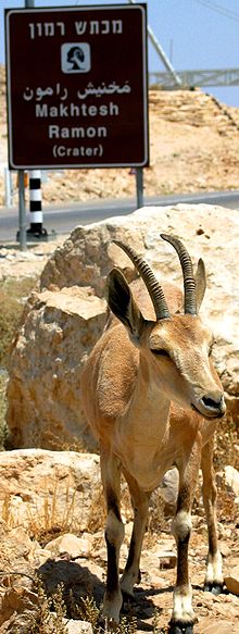 A Nubian Ibex by the entrance to Makhtesh Ramon
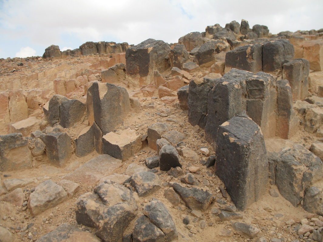
Makhtesh Ramon (Hebrew: מכתש רמון; lit. Ramon Crater/Makhtesh) is a geological feature of Israel's Negev desert. Located at the peak of Mount Negev, some 85 km south of the city of Beersheba, the landform is not actually an impact crater from a meteor, but rather is the world's largest makhtesh. The crater is 40 km long, 2-10 km wide and 500 meters deep, and is shaped like an elongated heart. The only settlement in the area is the small town of Mitzpe Ramon (מצפה רמון, "Ramon Observation Point") located on the northern edge of the crater. Today the crater and surrounding area forms Israel's largest national park, the Ramon Nature Reserve.
Contents
Formation
Hundreds of millions of years ago, the Negev desert was covered by an ocean. Slowly, this started to recede northwards leaving behind a hump-shaped hill. The hump was slowly flattened by water and climatic forces. Approximately five million years ago, the Arava Rift Valley was formed, with rivers changing their courses, carving out the inside of the crater which was a softer rock than that overlying. The crater bottom continued to deepen at a much faster rate than the surrounding walls, which gradually increased in height. As the crater deepened, more layers of ancient rock were exposed with rocks at the bottom of the crater being up to 200 million years old. Today, the crater is 500m deep with the deepest point being Ein Saharonim (Saharonim Spring) which also contains the makhtesh's only natural water source which sustain much of the wildlife in the makhtesh including onagers and ibex.
Geology
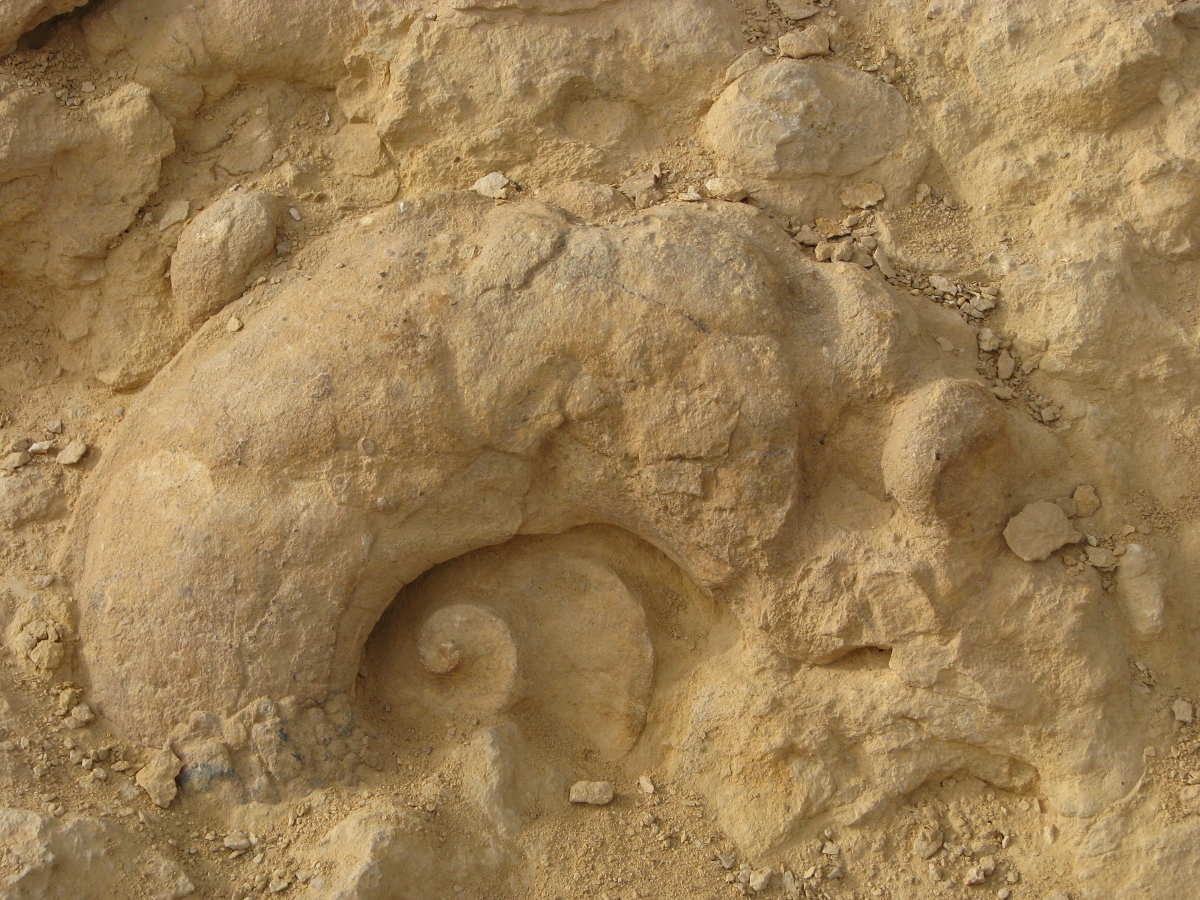
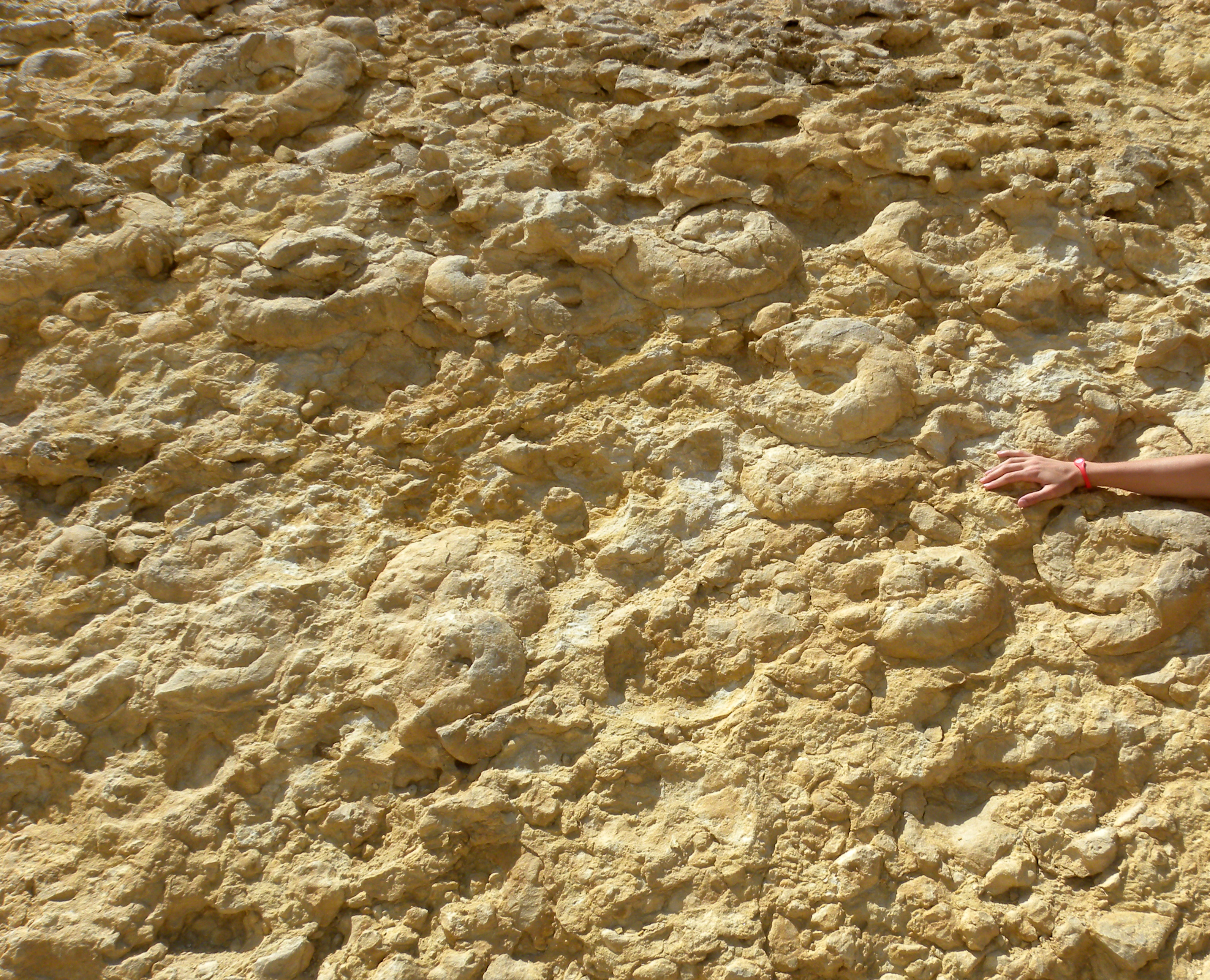
Makhtesh Ramon contains a diversity of rocks including clay hills known for their fantastic red and yellow colors and forms. Impressive mountains rise at the borders of the crater - Har Ramon (Mt. Ramon) at the southern end, Har Ardon (Mt. Ardon) at the north-eastern end, and two table mountains - Har Marpek (Mt. Marpek - "Elbow"), and Har Katum (Mt. Katum - "Chopped") along the southern wall. The hills to the north-eastern edge of the makhtesh were once entirely covered by spiral ammonite fossils, ranging from the size of snails to that of tractor wheels although these have mainly been extracted so only smaller fossils can be found here today.
Giv'at Ga'ash, a black hill in the north of the makhtesh was once an active volcano which erupted thousands of years ago and caused it to be covered in lava which quickly cooled in the open air, converting it into basalt. Limestone covered by basalt can also be found in smaller black hills in the southern part of the makhtesh, including Karnei Ramon.
Shen Ramon (Ramon's Tooth) is a rock made of magma which hardened whilst underground. It later rose up through cracks in the Earth's surface, and today stands in striking contrast with the nearby creamy coloured southern wall of the crater, as a black sharp-edged rock.
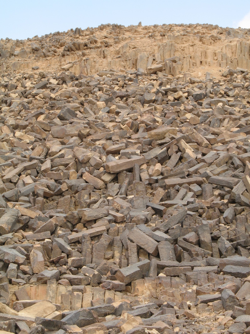
In the centre of the makhtesh is Ha-Minsara (The Carpentry Shop), a low hill made up of black prismatic rocks, and interestingly, the rectangular pipes on the side of the hill are made of the same sort of sand found on beaches. As such, this is the only place in the world where prisms made of heated sand turned into liquid which, in cooling naturally formed rectangular and hexagonal prisms, can be seen. These prisms lost no space in the middle during formation.
The pterioid bivalve Family Ramonalinidae is found in early Middle Triassic rocks of Makhtesh Ramon and was named after this feature.
Fauna
The Asian Wild Ass has been reintroduced to Makhtesh Ramon. In 1995 the population had increased to 40 adults in the area. The animals are hybrids of two different subspecies of the Asian Wild Ass. It is derived from the Turkmenian Kulan (E. h. kulan) and the Persian Onager (E. h. onager). The original subspecies, the Syrian Wild Ass (E. h. hemippus), is completely extinct.[1] Other larger mammals of the area include Nubian Ibexes, Dorcas Gazelles, Striped Hyenas and few Arabian Leopards.
History
The ruins of a large prehistoric stone structure known as Khan Saharonim are found in the makhtesh as it lies along the ancient Incense Route, a trade route used by the Nabateans 2,000 years ago. These ruins acted as a way station for the traders and their animals (khan is the Arabic word for a caravansary) as they proceeding further westwards to the Mediterranean seaport city of Gaza.
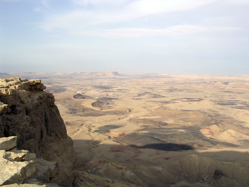
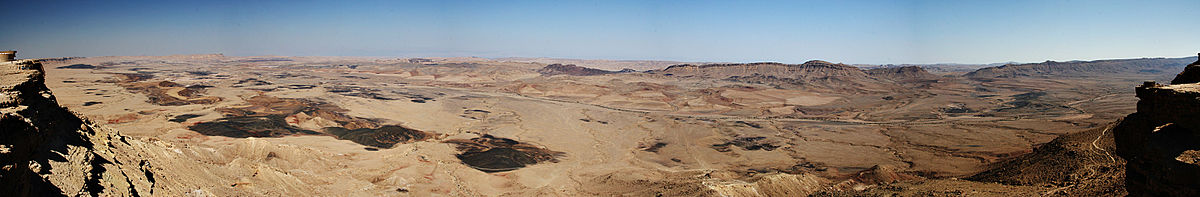 Wide panorama of the Makhtesh Ramon crater, Israel
Gallery
-

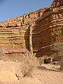
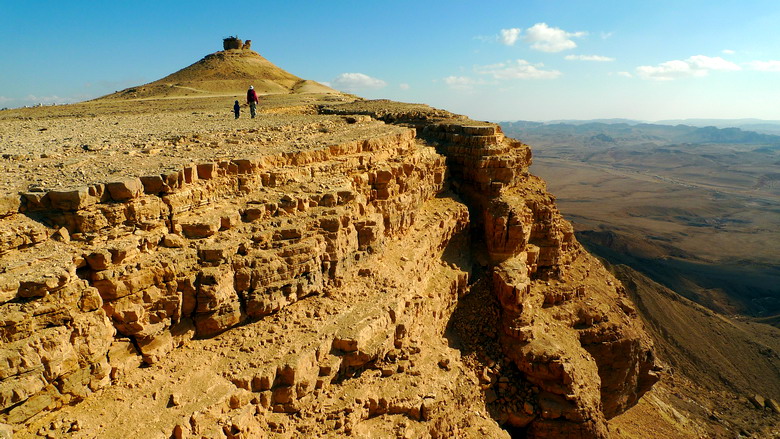
The cliff of Makhtesh Ramon.
-

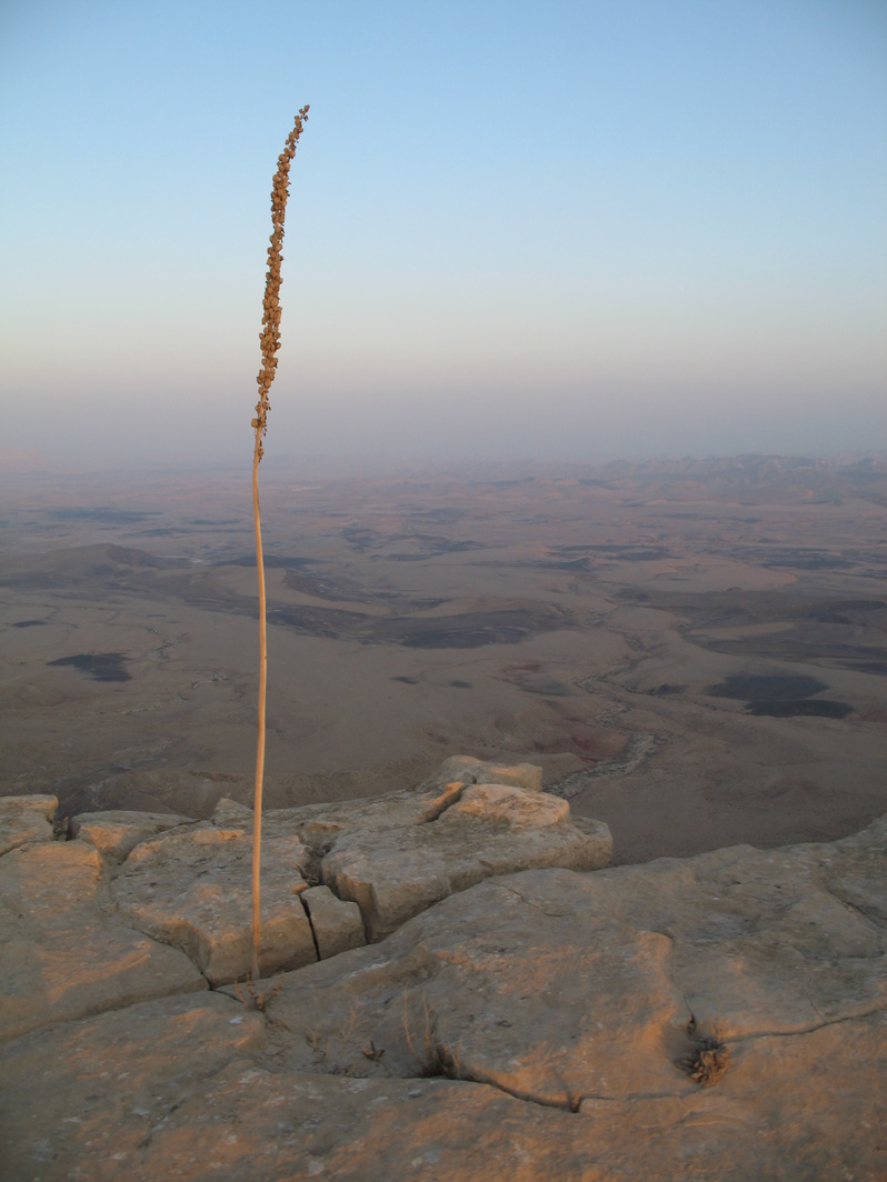
Dry Drimia maritima (Urginea maritima), at the north edge of Makhtesh Ramon.
-
Rock formation in Makhtesh Ramon.
-

Ha-Minsara (The Carpentry Shop) in Makhtesh Ramon.
-

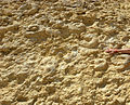
Sandy rectangular and hexagonal prisms at the centre of Makhtesh Ramon - Ha-Minsara (The Carpentry Shop).
-

An ammonite in the Ammonite Wall in Makhtesh Ramon
-
Ammonite Wall in Makhtesh Ramon (Tamar Formation, Cenomanian).
References
- ^ David Saltz David, Mary Rowen, Daniel I. Rubenstein: The Effect of Space-Use Patterns of Reintroduced Asiatic Wild Ass on Effective Population Size. Conservation Biology, Vol. 14, No. 6, 2000
- Mazor, Emanuel and Krasnov, Boris, editors "The Makhteshim Country - a Laboratory of Nature". Pensoft Publishers, Sofia, 2001: , ISBN 954-642-135-9, 411 pages
External links
- Ramon Crater on Google Maps
- Ramon Crater Detailed trail and hiking info. from Tourism, trips and travel in Israel
- Makhtesh Ramon's Visitors Center, at the Israel Nature and Parks Authority's website.
 Nature reserves of Israel
Northern District Ein Afek · Akhziv Islands · Alonei Yitzhak · Alonei Abba · Amud Stream · Nahal Ayun · Balfouria · Bitan Aharon · Nahal Betzet · Nahal Dishon · Dor Beach and Ma'agan Michael Islands · Ein Avazim · Ein Elah · Ein Nymphit · Ein Te'oh · Ein Yehuda · Nahal Gamal · Gamla nature reserve† · Snir Stream · Hermon nature reserve† · Nahal Hermon† · Hula Valley · Hurshat Tal · Hurshat Zakum · Kerem Ben Zimra · Nahal Kziv · Mount Arbel · Mount Carmel · Mount Gilboa · Mount Meron · Mount Tabor · Pa'ar Cave · Rosh HaNikra · Shamir-Nahal Rachum · Shimron · Nahal Taninim · Tel Anafa · Nahal Tavor · Tel Dan · Tel Shikmona · Nahal YehiamCentral District Adullam · Ashdod Nitzanim Sand Dune Park · Bnei Zion · Avshalom Cave · Ein Hemed · HaMasrek Reserve · Neot Kedumim · Nahal Poleg · Nahal Sorek · Tel Yitzhak · Te'omim Cave · UdimSouthern District Eilat Region Coral Beach Nature Reserve · Timna valley · Yotvata Hai-Bar† Located in the Israeli-occupied territories Categories:- Erosion landforms
- Landforms of Israel
- National parks of Israel
-


Wikimedia Foundation. 2010.