- Ein Gedi
-
This article is about the spring and nature reserve. For other uses, see Ein Gedi (disambiguation).
Coordinates: 31°27′0″N 35°23′0″E / 31.45°N 35.383333°E
Ein Gedi (Hebrew: עֵין גֶּדִי) is an oasis in Israel, located west of the Dead Sea, near Masada and the caves of Qumran.
Contents
Etymology
The name En-gedi is composed of two Hebrew words: ein means spring and gdi means goat-kid. En Gedi thus means "Kid spring."
History
Biblical era
In the 2 Chronicles 20:2 it is identified with Hazazon-tamar, where the Moabites and Ammonites gathered in order to fight Josaphat. In Genesis 14:7 Hazazon-tamar is mentioned as being a Amorite city, smitten by Chedorlaomer in his war against the cities of the plain.
In Joshua 15:62, Ein Gedi is enumerated among the cities of the Tribe of Judah in the desert Betharaba, but Ezekiel 47:10 shows that it was also a fisherman's town. Later, King David hides in the desert of En Gedi (1 Samuel 24:1-2) and King Saul seeks him "even upon the most craggy rocks, which are accessible only to wild goats" (1 Samuel 24:3).
The Song of Songs (Songs 1:14) speaks of the "vineyards of En Gedi"; the words, "I was exalted like a palm tree in Cades" (’en aígialoîs), which occur in Ecclesiasticus 24:18, may perhaps be understood of the palm trees of Ein Gedi.
The indigenous Jewish town of Ein Gedi was an important source of balsam for the Greco-Roman world until its destruction by Byzantine emperor Justinian as part of his persecution of the Jews in his realm. A synagogue mosaic remains from Ein Gedi's heyday, including a Judeo-Aramaic inscription warning inhabitants against "revealing the town's secret" – possibly the methods for extraction and preparation of the much-prized balsam resin, though not stated outright in the inscription – to the outside world.[1]
Modern era
In April 1848, Lieutenant William Francis Lynch led an American expedition down the Jordan River into the Dead Sea, that stopped at En Gedi (Ain Jidy).[2]
Ein Gedi nature reserve and national park
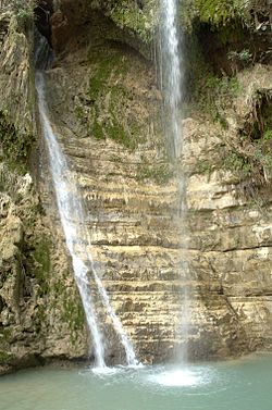
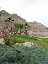
Ein Gedi nature reserve was declared in 1971[3] and is one of the most important reserves in Israel. The park is situated on the eastern border of the Judean Desert, on the Dead Sea coast, and covers an area of 14000 dunams[3]. The elevation of the land ranges from the level of the Dead Sea at 423 meters (1,388 ft) below sea level to the plateau of the Judean Desert at 200 meters above sea level. Ein Gedi nature reserve includes two spring-fed streams with flowing water year-round: Nahal David and Nahal Arugot. Two other springs, the Shulamit and Ein Gedi springs, also flow in the reserve. Together, the springs generate approximately three million cubic meters of water per year. Much of the water is used for agriculture or is bottled for consumption. The reserve is a sanctuary for many types of plant, bird and animal species. The vegetation includes plants and trees from the tropical, desert, Mediterranean, and steppian regions, such as Sodom apple, acacia, jujube, and poplar. The many species of resident birds are supplemented by over 200 additional species during the migration periods in the spring and fall. Mammal species include the ibex and the hyrax. In the summer of 2005, nearly two-thirds of the oasis burned to the ground after a visitor dropped a lit cigarette.
The Ein Gedi national park features several archaeological sites including the Chalcolithic Temple of Ein Gedi and a first century CE village. The park was declared in 2002 and covers an area of 8 dunams.[3]
Kibbutz Ein Gedi
Main article: Ein Gedi (kibbutz)Kibbutz Ein Gedi, founded in 1956, is located about a kilometer from the oasis. It offers various tourist attractions and takes advantage of the local weather patterns and the abundance of natural water to cultivate out-of-season produce. The kibbutz area contains an internationally acclaimed botanical garden covering an area of 100 dunams (10 ha, 24.7 acres). There one can find more than 900 species of plants from all over the world.
Shalom Marathon - Dead Sea Half Marathon
The Ein Gedi race, also known as the Shalom Marathon – Dead Sea Half Marathon is a popular road running event over several distances that has been held by the Tamar Regional Council since 1983. The starting point for all races is the Ein Gedi Spa, 80 kilometers (50 mi) southeast of Jerusalem and 4 kilometers south of Kibbutz Ein Gedi[4][5]
See also
References
- ^ Ein Gedi, A Streamlined approach
- ^ William Francis Lynch (1852). Narrative of the United States' expedition to the river Jordan and the Dead sea. Blanchard and Lea. pp. 282–296. http://books.google.com/books?id=EtsLAAAAYAAJ&pg=PR17. Retrieved 10 November 2010.
- ^ a b c "List of National Parks and Nature Reserves" (in Hebrew). Israel Nature and Parks Authority. http://parks.org.il/sigalit/muchrazim.pdf. Retrieved 2010-09-27.
- ^ "Ein-Gedi Race"
- ^ "Runners collapse near Dead Sea as temperatures hit seasonal highs"
Bibliography
- Hirschfeld, Y. (ed.), Ein Gedi. ‘A Very Large Village of Jews’ (Hecht Museum, University of Haifa, 2006).
External links
- Virtual Tour of Ein Gedi - View from the Ein Gedi Promenade
- Ein Gedi in the Dead Sea Map - Bird's-eye view in Flash
- The Israel Nature and Parks Authority - Site page
- Ein Gedi Travel Guide
- Pictures of Ein Gedi synagogue
- Ein Gedi mill, 1893
 Nature reserves of Israel
Northern District Ein Afek · Akhziv Islands · Alonei Yitzhak · Alonei Abba · Amud Stream · Nahal Ayun · Balfouria · Bitan Aharon · Nahal Betzet · Nahal Dishon · Dor Beach and Ma'agan Michael Islands · Ein Avazim · Ein Elah · Ein Nymphit · Ein Te'oh · Ein Yehuda · Nahal Gamal · Gamla nature reserve† · Snir Stream · Hermon nature reserve† · Nahal Hermon† · Hula Valley · Hurshat Tal · Hurshat Zakum · Kerem Ben Zimra · Nahal Kziv · Mount Arbel · Mount Carmel · Mount Gilboa · Mount Meron · Mount Tabor · Pa'ar Cave · Rosh HaNikra · Shamir-Nahal Rachum · Shimron · Nahal Taninim · Tel Anafa · Nahal Tavor · Tel Dan · Tel Shikmona · Nahal YehiamCentral District Adullam · Ashdod Nitzanim Sand Dune Park · Bnei Zion · Avshalom Cave · Ein Hemed · HaMasrek Reserve · Neot Kedumim · Nahal Poleg · Nahal Sorek · Tel Yitzhak · Te'omim Cave · UdimSouthern District Eilat Region National parks of Israel Jerusalem District Bayt 'Itab · Canada Park · Castel · City of David National Park1 · Ein Hemed · Judaean Mountains · Tomb of Samuel1North District Achziv · Bar'am National Park · Beit Alfa Synagogue · Beit She'an · Beit She'arim · Belvoir Fortress · Capernaum · Chorazin · Gan HaShlosha · Hamat Gader · Hamat Tiberias · Harod Spring · Hermon National Park1 · Hexagons pool · Horns of Hattin · Hurshat Tal · Hurvat Minia · Kursi1 · Montfort Castle · Mount Arbel · Mount Tabor · Nimrod Fortress1 · Rosh HaNikra · Sde Amudim · Sussita · Tel Hazor · Tel Kedesh · Tel Megiddo · Tzalmon Stream · Tzippori · Yehi'am Fortress · Hula ValleyHaifa District Central District Alexander stream · Arsuf · Hof HaSharon · Mazor Mausoleum · Migdal Afek · Palmachim beach · Rubin Stream · Sidna Ali · Tel Afek · Tel Gezer · Tzur Natan park · Yarkon National ParkSouthern District Ashkelon National Park · Avdat · Besor Stream · Beit Guvrin National Park · Ein Avdat · Ein Gedi · Eshkol Park · Mamshit · Masada · Monument to the Negev Brigade · Nitzana · Semekh caves · Shivta · Tel Arad · Tel Be'er Sheva · Tel Lachish · Tel ZafitJudea and Samaria Area Categories:- Nature reserves in Israel
- National parks of Israel
- Hebrew Bible places
- Oases
- Springs of Israel
- Sites of Special Scientific Interest notified in 1972
- Botanical gardens in Israel
Wikimedia Foundation. 2010.


