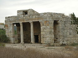
- Mazor Mausoleum
-

Mazor MausoleumLocation  Mazor, Israel
Built in 3rd century AD Built by/for Unknown Type of structure Mausoleum The Mazor Mausoleum (Hebrew: מאוזוליאום מזור) is one of the most impressive and best preserved Roman buildings in Israel, located in El'ad. The Mausoleum, which is the only Roman era building in Israel to still stand from its foundations to its roof, was built for an important Roman man and his wife in the 3rd century AD. Their identities remain a mystery but one can still see the remnants of two sarcophagi in the mausoleum.
Muslim Period
In the Late Antiquity, the Muslims added a prayer niche in the southern wall, indicating the direction of Mecca, and the building became an Islamic holy place called Maqam en Neby Yahyah (Shrine of the Prophet John).[1] Due to its sacredness, the building was preserved through the ages.[2] It functioned as a mosque until the depopulation of the Palestinian village Al-Muzayri'a in 1948.
In July 1949 Israel decided to raze the mausoleum (after the Israeli army had used the building for target practice), however an antiquities inspector managed to stop the destruction.[3]
References
- ^ C. R. Conder and H. H. Kitchener (1882). The Survey of Western Palestine. II. London: The Committe of the Palestine Exploration Fund. p. p.365.
- ^ "The Mazor Mausoleum". Ministry of Tourism - The State of Israel. http://www.tourism.gov.il/Tourism_Eng/Articles/Sites/The+Mazor+Mausoleum.htm. Retrieved 2009-01-13.
- ^ History Erased, by Meron Rapoport, Haaretz, 05.07.07
Bibliography
National parks of Israel Jerusalem District Bayt 'Itab · Canada Park · Castel · City of David National Park1 · Ein Hemed · Judaean Mountains · Tomb of Samuel1North District Achziv · Bar'am National Park · Beit Alfa Synagogue · Beit She'an · Beit She'arim · Belvoir Fortress · Capernaum · Chorazin · Gan HaShlosha · Hamat Gader · Hamat Tiberias · Harod Spring · Hermon National Park1 · Hexagons pool · Horns of Hattin · Hurshat Tal · Hurvat Minia · Kursi1 · Montfort Castle · Mount Arbel · Mount Tabor · Nimrod Fortress1 · Rosh HaNikra · Sde Amudim · Sussita · Tel Hazor · Tel Kedesh · Tel Megiddo · Tzalmon Stream · Tzippori · Yehi'am Fortress · Hula ValleyHaifa District Central District Alexander stream · Arsuf · Hof HaSharon · Mazor Mausoleum · Migdal Afek · Palmachim beach · Rubin Stream · Sidna Ali · Tel Afek · Tel Gezer · Tzur Natan park · Yarkon National ParkSouthern District Ashkelon National Park · Avdat · Besor Stream · Beit Guvrin National Park · Ein Avdat · Ein Gedi · Eshkol Park · Mamshit · Masada · Monument to the Negev Brigade · Nitzana · Semekh caves · Shivta · Tel Arad · Tel Be'er Sheva · Tel Lachish · Tel ZafitJudea and Samaria Area 1 Located in the Israeli-occupied territories
Coordinates: 32°2′47.58″N 34°56′46.05″E / 32.04655°N 34.946125°ECategories:- Archaeological sites in Israel
- National parks of Israel
- Islamic holy places
- Jews and Judaism in the Roman Empire
- Ancient Roman architecture
- Roman archaeology
- 3rd-century architecture
Wikimedia Foundation. 2010.


