- Samaria
-
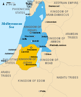
 Map the Northern and Southern Kingdoms. Samaria was the capital of the Kingdom of Israel (in blue). 830s BC.
Samaria, or the Shomron (Hebrew: שֹׁמְרוֹן, Standard Šoməron Tiberian Šōmərôn; Greek: Σαμάρεια; Arabic: سامريّون, Sāmariyyūn or السامرة, as-Samarah – also known as جبال نابلس, Jibal Nablus) is a term used for a mountainous region roughly corresponding to the northern part of the West Bank.
Contents
Etymology
The name "Samaria" derives from an ancient city of the same name, which was located near the south of Samaria, and was the capital of the Kingdom of Israel. According to 1 Kings 16:24, it is derived from the individual [or clan] Shemer, from whom Omri purchased the site. The name was the only name used for this area from ancient times until the Jordanian conquest of 1948, at which point the Jordanian occupiers coined the term West Bank.[1]
Geographical location
To the north, Samaria is bounded by the Jezreel Valley; to the east by the Jordan Rift Valley; to the west by the Carmel Ridge (in the north) and the Sharon plain (in the west); to the south by the Jerusalem mountains. In Biblical times, Samaria "reached from the [Mediterranean] sea to the Jordan Valley",[2] including the Carmel Ridge and Plain of Sharon. The Samarian hills are not very high, seldom reaching the height of over 800 metres. Samaria's climate is more hospitable than the climate further south.
Political control
The modern history of Samaria begins when the territory of Samaria, formerly part of the Ottoman Empire, was entrusted to the United Kingdom to administer in the aftermath of World War I as a British Mandate of Palestine, by the League of Nations. As a result of the 1948 Arab-Israeli War the territory was unilaterally incorporated as Jordanian-controlled territory and residents would later receive Jordanian passports. The areas of Samaria and Judea conquered by Jordan were renamed the West Bank (of the Jordan river).[citation needed]
Samaria came under the control of Israel during the 1967 Six-Day War. Jordan ceded control of the area to the PLO [West Bank, including Samaria], in November 1988- later confirmed by the Israeli-Jordanian peace treaty of 1993. Jordan instead recognizes the Palestinian Authority as sovereign in the territory. In the 1994 Oslo accords, responsibility for the administration over some of the territory of Samaria (Areas 'A' and 'B') was transferred to the Palestinian Authority.
Samaria is one of the several standard statistical "areas" utilized by the Israel Central Bureau of Statistics.[3] "The Israeli CBS also collects statistics on the rest of the West Bank and the Gaza District. It has produced various basic statistical series on the territories, dealing with population, employment, wages, external trade, national accounts, and various other topics."[4] The Palestinian Authority however use Nablus, Tulkarm, Jenin, Qalqilya, Salfit, Ramallah and Tubas Governorates as administrative centres for the same region.
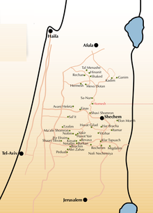
The Shomron Regional Council administers the Jewish communities and settlements throughout the northern Samaria area.
Israel has been criticized for the policy of establishing settlements in Samaria. Israel's position is that the legal status of the land is unclear. On March 22, 1979, the UN Security Council approved resolution 446 which unambiguously stated settlements in the occupied West Bank and Jerusalem were illegal.
Samaritans
Ethnically, the Samaritans are the inhabitants of Samaria after the beginning of the Assyrian Exile of the Israelites.[5] When Assyria overran the Northern Kingdom of Israel in 722 BC, part of the Israelite population was deported, and other peoples from the Assyrian Empire were resettled in Israel. Sargon claimed in Assyrian annals that he carried away 27,280 inhabitants from Samaria, the capital of Kingdom of Israel.[6] This could not have been the entire population; many Israelites must have remained.[7]
The inhabitants worshiped the Greek gods, but when the then-sparsely populated areas became infested with dangerous wild beasts, they appealed to the king of Assyria for Israelite priests to instruct them on how to worship the "God of that country." The result was a syncretistic religion, in which national groups worshiped the Hebrew god, but they also served their own gods in accordance with the customs of the nations from which they had been brought.[dubious ] Samaritans claim to be descendants of Israelites from the Northern Kingdom who escaped deportation and exile.
A genetic study concluded from Y-chromosome analysis that Samaritans descend from the Israelites (including Kohanim, or priests), and mitochondrial DNA analysis shows descent from Assyrians and other foreign women, effectively validating both local and foreign origins for the Samaritans. (Shen et al., 2004)[1]
Samaritanism is a religion closely related to Judaism, though it is not considered part of it, and its adherents are not considered Jews. Samaritanism primarily uses a Torah as its holy book, though little of later Jewish theology. Their temple was built at Mount Gerizim in the middle of fifth century BC and was destroyed by the Macabbean (Hasmonean) John Hyrcanus late in 110 BC, although their descendants still worship among its ruins. The antagonism between Samaritans and Jews is important in understanding the Christian Bible's stories of "Parable of the Good Samaritan" and the "Samaritan woman at the well".
History
The city Samaria was established as the capital of the Kingdom of Israel during the reign of Omri circa 884 BC. Prior to the Omride period the site appears to have been the center of an extensive wine and oil production area, which may have accounted for its choice as the new capital. Apparently the origin of the name of the site was from Shemer the eponymous owner of the land that Omri purchased for two talents of silver (1 Kings 16:23-24).
The city is built on the summit of a rocky hill, and all the remains discovered so far date from the Roman era and were built according to the Roman style. The earliest remains consist of extensive rock cut installations, initially thought to date to the Early Bronze Age by Kenyon, these have recently been re-evaluated, first by Stager and then by Franklin, and are now recognized to be the remains of an extensive early Iron Age oil and wine industry (designated Building Period 0).
New Testament reference
The New Testament mentions Samaria in Luke chapter 17:11-20, in the miraculous healing of the ten lepers, which took place on the border of Samaria and Galilee. John 4:1-26 records Jesus' encounter at Jacob's well with the woman of Sychar, in which he declares himself to be the Messiah. In Acts 8:5-14, it is recorded that Philip went down to the city of Samaria and preached there. In the time of Jesus, Iudaea of the Romans was divided into three toparchies, Judea, Samaria, and Galilee. Samaria occupied the centre of Iudaea (John 4:4). (Iudaea was later renamed Syria Palaestina in 135, following the Bar Kokhba revolt.) In the Talmud, Samaria is called the "land of the Cuthim".
See also
- Archevites
- Samaritan Revolts
- Good Samaritan
References
- ^ "This Side of the River Jordan; On Language," Philologos, September 22, 2010, Forward.
- ^ Nelson's Encyclopædia, v. IX, p. 204, (London, 1907)
- ^ Israel Central Bureau of Statistics
- ^ Israeli Ministry of Foreign Affairs
- ^ 2 Kings 17 and Josephus (Ant 9.277–91)
- ^ Sg II Nimrud Prism IV:25-41
- ^ Encyclopædia Britannica, 11th Ed., v. 24, p. 109 (London, 1910)
Bibliography
- Rainey, A. F. (November 1988). "Toward a Precise Date for the Samaria Ostraca". Bulletin of the American Schools of Oriental Research 272 (272): 69–74. doi:10.2307/1356786. JSTOR 1356786.
- Stager, L. E. (February–May 1990). "Shemer's Estate". Bulletin of the American Schools of Oriental Research 277/278 (277): 93–107. doi:10.2307/1357375. JSTOR 1357375.
- Becking, B. (1992). The Fall of Samaria: An Historical and Archaeological Study. Leiden; New York: E. J. Brill. ISBN 9004096337.
- Franklin, N. (2003). "The Tombs of the Kings of Israel". Zeitschrift des Deutschen Palästina-Vereins 119 (1): 1–11.
- Franklin, N. (2004). "Samaria: from the Bedrock to the Omride Palace". Levant 36: 189–202.
- Tappy, R. E. (2206). “The Provenance of the Unpublished Ivories from Samaria,” Pp. 637–56 in “I Will Speak the Riddles of Ancient Times” (Ps 78:2b): Archaeological and Historical Studies in Honor of Amihai Mazar on the Occasion of his Sixtieth Birthday, A. M. Maeir and P. de Miroschedji, eds. Winona Lake, IN: Eisenbrauns.
- Tappy, R. E. (2007). “The Final Years of Israelite Samaria: Toward a Dialogue between Texts and Archaeology,” Pp. 258–79 in Up to the Gates of Ekron: Essays on the Archaeology and History of the Eastern Mediterranean in Honor of Seymour Gitin, S. White Crawford, A. Ben-Tor, J. P. Dessel, W. G. Dever, A. Mazar, and J. Aviram, eds. Jerusalem: The W. F. Albright Institute of Archaeological Research and the Israel Exploration Society.
External links
- Entry for Samaria in 1911 Encyclopaedia Britannica
- Shomron National Park (Sebastia) at Israel Nature and Parks Authority site
- Pictures of the ruins of Shomron
 "Samaria". Catholic Encyclopedia. New York: Robert Appleton Company. 1913.
Coordinates: 32°08′35″N 35°15′38″E / 32.14306°N 35.26062°E
 Judea and Samaria Area
Cities 
Regional committee Local councils Alfei Menashe · Beit Aryeh-Ofarim · Beit El · Efrat · Elkana · Giv'at Ze'ev · Har Adar · Immanuel · Karnei Shomron · Kedumim · Kiryat Arba · Ma'ale Efrayim · OranitRegional councils Region: West Bank
Other sub-divisions: Center District · Haifa District · Jerusalem District · North District · South District · Tel Aviv District
See also: Population statistics · Israeli settlement · Violence · International law · Israeli settlement timeline · Israeli West Bank barrierNational parks of Israel Jerusalem District Bayt 'Itab · Canada Park · Castel · City of David National Park1 · Ein Hemed · Judaean Mountains · Tomb of Samuel1North District Achziv · Bar'am National Park · Beit Alfa Synagogue · Beit She'an · Beit She'arim · Belvoir Fortress · Capernaum · Chorazin · Gan HaShlosha · Hamat Gader · Hamat Tiberias · Harod Spring · Hermon National Park1 · Hexagons pool · Horns of Hattin · Hurshat Tal · Hurvat Minia · Kursi1 · Montfort Castle · Mount Arbel · Mount Tabor · Nimrod Fortress1 · Rosh HaNikra · Sde Amudim · Sussita · Tel Hazor · Tel Kedesh · Tel Megiddo · Tzalmon Stream · Tzippori · Yehi'am Fortress · Hula ValleyHaifa District Central District Alexander stream · Arsuf · Hof HaSharon · Mazor Mausoleum · Migdal Afek · Palmachim beach · Rubin Stream · Sidna Ali · Tel Afek · Tel Gezer · Tzur Natan park · Yarkon National ParkSouthern District Ashkelon National Park · Avdat · Besor Stream · Beit Guvrin National Park · Ein Avdat · Ein Gedi · Eshkol Park · Mamshit · Masada · Monument to the Negev Brigade · Nitzana · Semekh caves · Shivta · Tel Arad · Tel Be'er Sheva · Tel Lachish · Tel ZafitJudea and Samaria Area Categories:- West Bank
- Judea and Samaria
- Geography of Palestine
- Geography of the West Bank
- Hebrew Bible places
- New Testament places
- Samaritan culture and history
Wikimedia Foundation. 2010.

