- Beit Aryeh-Ofarim
-
Beit Aryeh Hebrew transcription(s) – Hebrew בֵּית אַרְיֵה-עֳפָרִים, בית אריה-עופרים – ISO 259 Beit ʔarye - ʕoparim 
Logo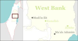
 Beit Aryeh
Coordinates: 32°2′7.79″N 35°3′13.68″E / 32.0354972°N 35.0538°ECoordinates: 32°2′7.79″N 35°3′13.68″E / 32.0354972°N 35.0538°E Region West Bank District Judea and Samaria Area Government – Type Local council (from 1989) – Head of Municipality Avi Naim Area – Total 8,500 dunams (8.5 km2 / 3.3 sq mi) Name meaning House of Aryeh - Fawns Beit Aryeh-Ofarim (Hebrew: בֵּית אַרְיֵה-עֳפָרִים) is an Israeli settlement and local council in the northern West Bank. The international community considers Israeli settlements in the West Bank illegal under international law, but the Israeli government disputes this.[1]
Beit Aryeh was recognised as a local council in 1989, and had Ofarim appended to it in 2004. The settlement was named after Aryeh Ben-Eliezer, a Lithuanian born Zionist leader before the state of Israel was founded and a member of the Israeli parliament in the 1950s and 1960s.
References
- ^ "The Geneva Convention". BBC News. 10 December 2009. http://news.bbc.co.uk/2/hi/middle_east/1682640.stm. Retrieved 27 November 2010.
External links
- Local council website (Hebrew)
 Judea and Samaria Area
Cities 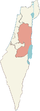
Regional committee Local councils Alfei Menashe · Beit Aryeh-Ofarim · Beit El · Efrat · Elkana · Giv'at Ze'ev · Har Adar · Immanuel · Karnei Shomron · Kedumim · Kiryat Arba · Ma'ale Efrayim · OranitRegional councils Region: West Bank
Other sub-divisions: Center District · Haifa District · Jerusalem District · North District · South District · Tel Aviv District
See also: Population statistics · Israeli settlement · Violence · International law · Israeli settlement timeline · Israeli West Bank barrierCategories:- West Bank
- Judea and Samaria
- Local councils in Israel
- Israeli settlements
- Israel geography stubs

Wikimedia Foundation. 2010.