- Nahal Ayun
-
Coordinates: 33°16′11.42″N 35°34′40.26″E / 33.2698389°N 35.57785°E
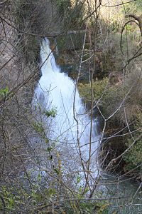 Ayun waterfall
Nahal Ayun (Hebrew: נחל עיון, lit. Ayun Stream), is a perennial stream in the Galilee Panhandle, Israel. The stream originates from the springs in the Marjayoun valley in southern Lebanon, and runs southward for seven kilometers in various irrigation ditches, until flowing into Israel near Metulla, as a tributary of the Jordan River in the Hula Valley.[1]
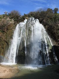 Tahana waterfall
Contents
Nature Reserve
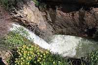 Eshed Fall
Differences in altitude form waterfalls in the streams course. During the rainy winter months, the water-flow is strongest. During the summer months, water is diverted, closer to the stream's sources, for crop irrigation. These falls were declared a nature reserve[2], and include:
- Ayun waterfall, 9.2 m
- Tahana waterfall (=flourmill), 21 m
- Eshed waterfall, with two steps, 5 m and 9 m
- Tanur waterfall, 30 m
Flora and fauna
Tree types in the reserve include Pistacia palaestina, Rhamnus palaestinus, and Acer obtusifolium Maples. Other growth includes Spanish Broom, Rubus, Cyclamen persicum, and Anemones.
Grey Wagtails can be found during the winter months, as well as White-throated Kingfishers and Common Kestrels.
See also
- Wildlife in Israel
- Tourism in Israel
References
- ^ "שמורת טבע נחל עיון (התנור) [The Nahal Ayun Nature Reserve (Tanur)]". Israel Nature and Parks Authority. http://www.parks.org.il/BuildaGate5/general2/data_card.php?Cat=~30~~315562256~Card1~&ru=&SiteName=parks&Clt=&Bur=624661230.
- ^ "Ha Tanunr (Nahal Ayun) Nature Reserve". ProtectedPlanet.com. http://www.protectedplanet.net/sites/Ha_Tanunr_Nahal_Ayoun_Nature_Reserve.
 Nature reserves of Israel
Northern District Ein Afek · Akhziv Islands · Alonei Yitzhak · Alonei Abba · Amud Stream · Nahal Ayun · Balfouria · Bitan Aharon · Nahal Betzet · Nahal Dishon · Dor Beach and Ma'agan Michael Islands · Ein Avazim · Ein Elah · Ein Nymphit · Ein Te'oh · Ein Yehuda · Nahal Gamal · Gamla nature reserve† · Snir Stream · Hermon nature reserve† · Nahal Hermon† · Hula Valley · Hurshat Tal · Hurshat Zakum · Kerem Ben Zimra · Nahal Kziv · Mount Arbel · Mount Carmel · Mount Gilboa · Mount Meron · Mount Tabor · Pa'ar Cave · Rosh HaNikra · Shamir-Nahal Rachum · Shimron · Nahal Taninim · Tel Anafa · Nahal Tavor · Tel Dan · Tel Shikmona · Nahal YehiamCentral District Adullam · Ashdod Nitzanim Sand Dune Park · Bnei Zion · Avshalom Cave · Ein Hemed · HaMasrek Reserve · Neot Kedumim · Nahal Poleg · Nahal Sorek · Tel Yitzhak · Te'omim Cave · UdimSouthern District Eilat Region Coral Beach Nature Reserve · Timna valley · Yotvata Hai-Bar† Located in the Israeli-occupied territories Categories:- Rivers of Israel
- Nature reserves in Israel


Wikimedia Foundation. 2010.