- Nahal Taninim
-
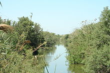
Nahal Taninim (Hebrew: נחל תנינים, lit. Crocodile Stream) is a river in Israel, originating near Ramot Menashe and emptying into the Mediterranean Sea south of Ma'agan Michael. The Arabic name for this river is Wadi a-Zarka.
The area of the basin and its tributaries is about 200 square kilometers, including the Taninim, Ada, Barkan, Alona and Mishmarot streams. Nahal Taninim is the cleanest of Israel’s coastal rivers. Three waterways meet in Nahal Taninim: the natural stream, a Roman aqueduct extending from the Zabrin springs to Caesarea, and Mifale Menashe, the waterworks that collect surface runoff water and springwater, routing it into the subterranean water table.[1]
The dense undergrowth and reeds along Nahal Taninim are home to many different birds, among them waterside warblers and other songbirds.[2]
According to a Tel Aviv University zoologist, the name derives from sightings of crocodiles and hippopotamuses by priests and pilgrims who trekked through the swamps three centuries ago.[3]
References
Coordinates: 32°32′51″N 34°54′54″E / 32.5475°N 34.915°E
 Nature reserves of Israel
Northern District Ein Afek · Akhziv Islands · Alonei Yitzhak · Alonei Abba · Amud Stream · Nahal Ayun · Balfouria · Bitan Aharon · Nahal Betzet · Nahal Dishon · Dor Beach and Ma'agan Michael Islands · Ein Avazim · Ein Elah · Ein Nymphit · Ein Te'oh · Ein Yehuda · Nahal Gamal · Gamla nature reserve† · Snir Stream · Hermon nature reserve† · Nahal Hermon† · Hula Valley · Hurshat Tal · Hurshat Zakum · Kerem Ben Zimra · Nahal Kziv · Mount Arbel · Mount Carmel · Mount Gilboa · Mount Meron · Mount Tabor · Pa'ar Cave · Rosh HaNikra · Shamir-Nahal Rachum · Shimron · Nahal Taninim · Tel Anafa · Nahal Tavor · Tel Dan · Tel Shikmona · Nahal YehiamCentral District Adullam · Ashdod Nitzanim Sand Dune Park · Bnei Zion · Avshalom Cave · Ein Hemed · HaMasrek Reserve · Neot Kedumim · Nahal Poleg · Nahal Sorek · Tel Yitzhak · Te'omim Cave · UdimSouthern District Eilat Region Categories:- Rivers of Israel
- Nature reserves in Israel
Wikimedia Foundation. 2010.

