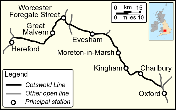
- Cotswold Line
-
Cotswold Line 
Overview Type Rural, Heavy rail System National Rail Status Operational Locale South East England
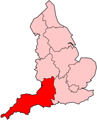
South West England
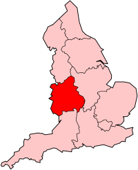
West MidlandsTermini Oxford
HerefordStations 19 Operation Opened 1851 Owner Network Rail Operator(s) First Great Western
London MidlandRolling stock Class 43 HST
Class 165
Class 166Technical No. of tracks 1–2 Track gauge Standard gauge 1,435 mm (4 ft 8 1⁄2 in) Cotswold Line Legend
miles (km) 
Cherwell Valley Line to Didcot 
0.0 miles (0 km) Oxford 

A34 road A40 road 
Sheepwash Channel 

0.9 miles (1.4 km) Oxford North Junction: Oxford to Bicester Line 
Wolvercot Platform A40 road A34 road Duke's Cut 2.9 miles (4.7 km) Wolvercot Jc: Cherwell Valley Line to Banbury 

former Varsity Line to Bletchley 3.8 miles (6.1 km) Yarnton 

Former Fairford Line 

River Evenlode 

7.0 miles (11.3 km) Hanborough A4095 road 

8.0 miles (12.9 km) Combe 
11.6 miles (18.7 km) Finstock 13.2 miles (21.2 km) Charlbury 16.9 miles (27.2 km) Ascott-under-Wychwood 
River Evenlode A361 road 18.2 miles (29.3 km) Shipton 19.7 miles (31.7 km) Bruern Crossing 21.2 miles (34.1 km) Kingham 


Former Banbury and Cheltenham Direct Railway A436 road 23.9 miles (38.5 km) Adlestrop A44 road 28.3 miles (45.5 km) Moreton-in-Marsh 
Former Stratford and Moreton Tramway
later Shipston-on-Stour branch31.5 miles (50.7 km) Blockley Blockley Chipping Campden 
34.3 miles (55.2 km) Campden Tunnel Mickleton Halt 


Honeybourne Line 
38.1 miles (61.3 km) (now freight only) 38.2 miles (61.5 km) Honeybourne 40.2 miles (64.7 km) Clayfield Littleton and Badsey A46 road River Avon (Upper Avon Navigation) 

Malvern Jct: former Midland Rly. line to Barnt Green 
43.2 miles (69.5 km) Evesham 


Former Midland Railway Malvern Line to Ashchurch River Avon (Lower Avon Navigation) River Avon (Lower Avon Navigation) 46.3 miles (74.5 km) Fladbury Wyre Halt 49.1 miles (79.0 km) Pershore 51.3 miles (82.6 km) Stoulton 


53.3 miles (85.8 km) Cross Country Route / proposed Norton Parkway 
53.8 miles (86.6 km) Norton Junction Norton Halt 
54.5 miles (87.7 km) M5 motorway 
A4440 road A44 road 57.0 miles (91.7 km) Worcester Shrub Hill 
57.3 miles (92.2 km) Rainbow Hill Jct: Birmingham - Worcester lines Worcester and Birmingham Canal 57.6 miles (92.7 km) Worcester Foregate Street 
A38 road 


Former freight branch 
River Severn 
A443 road A44 road A4440 road Henwick 60.3 miles (97.0 km) River Teme Leominster Junction: former line to Leominster Bransford Road Newland Halt 64.4 miles (103.6 km) Malvern Link A449 road 65.6 miles (105.6 km) Great Malvern Former Midland Railway Malvern Line to Evesham Malvern Wells 

67.1 miles (108.0 km) Colwall Tunnel and Colwall New Tunnel 
68.0 miles (109.4 km) 
68.4 miles (110.1 km) Colwall A449 road 72.1 miles (116.0 km) Ledbury Tunnel 72.6 miles (116.8 km) Ledbury Ledbury and Gloucester Railway 
Herefordshire and Gloucestershire Canal (disused) A417 road Ashperton Stoke Edith River Frome 81.9 miles (131.8 km) Withington A4103 road A465 road River Lugg (former navigation) Herefordshire and Gloucestershire Canal (disused) 
84.6 miles (136.2 km) Shelwick Junction: Welsh Marches Line to Crewe A4103 road 

Barrs Court Junction 86.3 miles (138.9 km) Hereford (Barrs Court) 
Welsh Marches Line to Newport The Cotswold Line is an 861⁄2-mile (139 km) railway line between Oxford and Hereford in England.
Contents
Route
The line comprises all or part of the following Network Rail routes:
- GW 200 from Oxford
- GW 310 from Wolvercot Junction
- GW 300 from Norton Junction
- GW 340 from Worcester Shrub Hill
- GW 730 from Shelwick Junction to Hereford
Infrastructure
The line is single track between the following places.
- Wolvercot Junction, (about 3 miles or 5 kilometres north of Oxford) and Charlbury.
- 1 mile or 1.6 kilometres west of Evesham and Norton Junction (3 miles or 4.8 kilometres south east of Worcester Shrub Hill)
- Worcester Shrub Hill and Worcester Foregate Street.
- Malvern Wells, (1 mile or 1.6 kilometres south of Great Malvern) and Hereford with a crossing place at Ledbury.
Other sections are double track.
Significant civil engineering structures on the line include Campden Tunnel (875 yards or 800 metres), Colwall New Tunnel (1,567 yards or 1,433 metres), Ledbury Tunnel (1,323 yards or 1,210 metres) and viaducts at Worcester and Ledbury.
Improvement Works 2008-2011
Network Rail completed the redoubling 20 miles (32 km) of track from just east of Charlbury to Ascott-under-Wychwood, and from Moreton-in-Marsh to about 1 mile (1.6 km) west of Evesham on 22 August 2011. This should improve reliability, enable non-stop operations and allow an hourly off peak service to run on the line.[1] The Office of Rail Regulation approved the work in June 2008, although the planned work was over-budget and had to await final approval.[citation needed] In December 2008 vegetation was cleared.[2] A six-week closure of all or part of the line between Oxford and Worcester for preparatory works took place in July and August 2009. Further weekend work planned for February 2010 was postponed by Network Rail. Initial work began in autumn of 2010, with the majority of the second track being relaid between December 2010 and May 2011 when the line was closed at 21.30 from Monday to Thursday. In March 2011 construction works were started on additional structures and signalling equipment that the new line needed, including three new platforms at Charlbury, Ascott-under-Wychwood and Honeybourne. Footbridges at Charlbury and Honeybourne as well as preparation for the upgrade of six Level Crossings.[3] The new double track section between Charlbury and Ascott re-opened on 6 June 2011; the line between Oxford and Moreton-in-Marsh having been closed during the previous nine days. The section between Moreton and Evesham reopened as double track on 22 August 2011 with the line closed for the preceding two weeks.[4]
There are proposals for new stations at Rushwick, Withington and Chipping Campden. A long-standing proposal for a new station at Worcester (Norton) Parkway where the line crosses the Birmingham and Bristol Railway has made little progress.
Services
As of 22 August 2011[update], the previous off peak service continues: roughly an hourly service between London and Worcester. Due to constraints of the former single track, there are some two hour gaps. These services are extensions of the half-hourly Oxford fast trains.
During peak hours, both Oxford fast trains are extended to Worcester, giving a half-hourly service. Overall, about half the trains continue to Great Malvern and five trains per day continue to and from Hereford.
There is also an additional commuter service to and from Oxford in the morning and evening, which additionally calls at the halts (their "Parliamentary" service, preventing their closure). The historic problem of some trains having to wait at passing loops, extending journey times, has been eliminated by the redoubling.
Due to short platforms, passengers alighting at stations except Shrub Hill, Oxford and Hereford should listen to onboard announcements telling them from which coaches they should alight. Normally this is from the 2–5 coaches at the country end of the train (further from the ticket barrier at London Paddington).
History
The line between Oxford and Worcester was built under an 1845 Act of Parliament and opened in 1851 as part of the Oxford, Worcester and Wolverhampton Railway.
The Act required the line to be built to Isambard Kingdom Brunel's 7 feet 1/4 inches (2,140 mm) broad gauge but delays, disputes and increasing costs led to its being completed as 1,435 mm (4 ft 8 1⁄2 in) standard gauge.[citation needed]
The first stage of the Worcester and Hereford Railway opened between Henwick and Malvern Link on 25 July 1859. The bridge over the River Severn was approved for traffic the following year, and trains started running through from Malvern Link to Worcester Shrub Hill station on 17 May 1860. A short extension from Malvern Link to Malvern Wells opened on 25 May 1860.
On 1 July 1860 the Oxford, Worcester and Wolverhampton Railway absorbed both the Worcester & Hereford Railway and the Newport, Abergavenny & Hereford Railway to form the West Midland Railway.
On 13 September 1861 the final stage of the railway opened between Malvern Wells and Shelwick Junction. This junction is just north of Hereford station on the line between Hereford and Shrewsbury, and it finally created a through route between Worcester and Hereford.[5]
The Great Western Railway took over the West Midland Railway in 1863.
The original tunnel through the ridge of the Malvern Hills, Colwall Tunnel, was completed in July 1860. However, the tunnel was unstable, and it was closed for short periods in 1861 and again in 1907 following rock falls. Eventually the GWR decided to build a new tunnel to the south of the existing one. This opened for traffic on 2 August 1926. The old tunnel was abandoned, and during the Second World War it was used to store torpedoes.[6]
Following serious floods, which washed parts of embankments away, the line was closed for about a fortnight during July and August 2007 for repairs.
In 2007 some trains in the morning rush hour started at Abergavenny but this was discontinued from December 2008.
Poetry
The line features in two notable poems: Adlestrop by Edward Thomas and Pershore Station, or A Liverish Journey First Class by Sir John Betjeman.
Route detail
Oxford to Charlbury
After departing Oxford station, the Cotswold Line shares track with the Cherwell Valley Line to Banbury. About 220 yards (200 m) north of the station, the line crosses the Sheepwash Channel which links the Oxford Canal to the River Thames. Immediately east of the current line is a swing bridge over the channel which used to carry the London and North Western Railway's Buckinghamshire Railway line to its Oxford Rewley Road station. The swing bridge is a listed building. The Rweley Road station building has been dismantled and re-erected at Buckinghamshire Railway Centre. The built up area east of the railway, visible across the Oxford Canal, is Jericho, a district which originated as lodgings outside the city walls where travellers could rest if they arrived after the gates were locked. The Eagle Ironworks of William Lucy & Co. was near the first road bridge over the track on Walton Well Road.
After the bridge, the open area to the left is Port Meadow, a water meadow bordering the Thames with a Bronze Age round barrow. The former LNWR Buckinghamshire Railway branches away to the north east. Proposals exist for re-opening the whole line and are included in the Draft Milton Keynes & South Midlands Sub-Regional Strategy, but there are many planning and funding matters to be resolved.[7]
The line passes through Wolvercote. To the west, Lower Wolvercote was a centre for paper making, mainly for the Oxford University Press from the 17th century until 1998 and is the site of Godstow abbey, a Benedictine convent founded in the 12th century. The line passes under the viaduct carrying the A34 Oxford Western Bypass and 100 yards (91 m) further under the A40 road linking London and Fishguard.
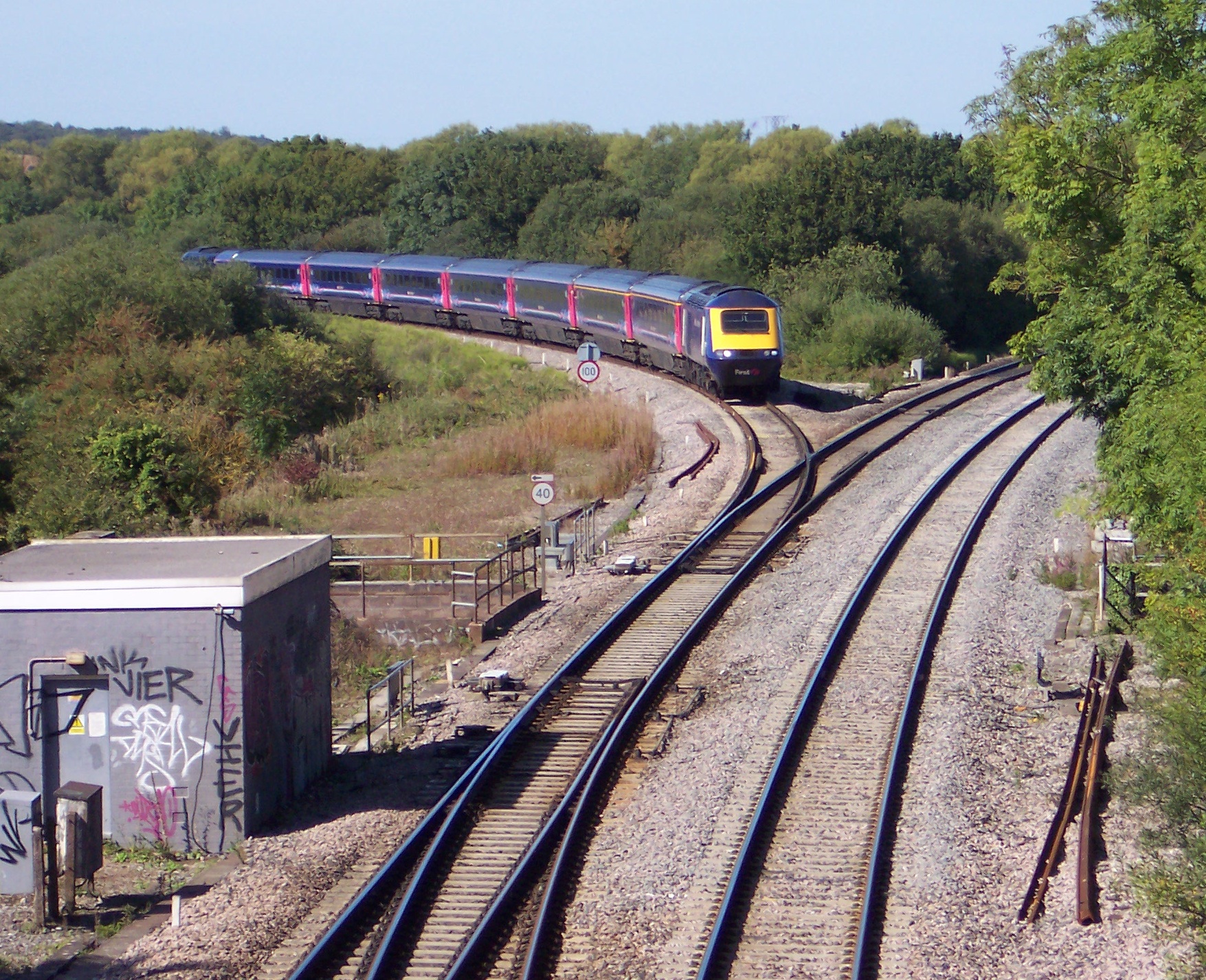
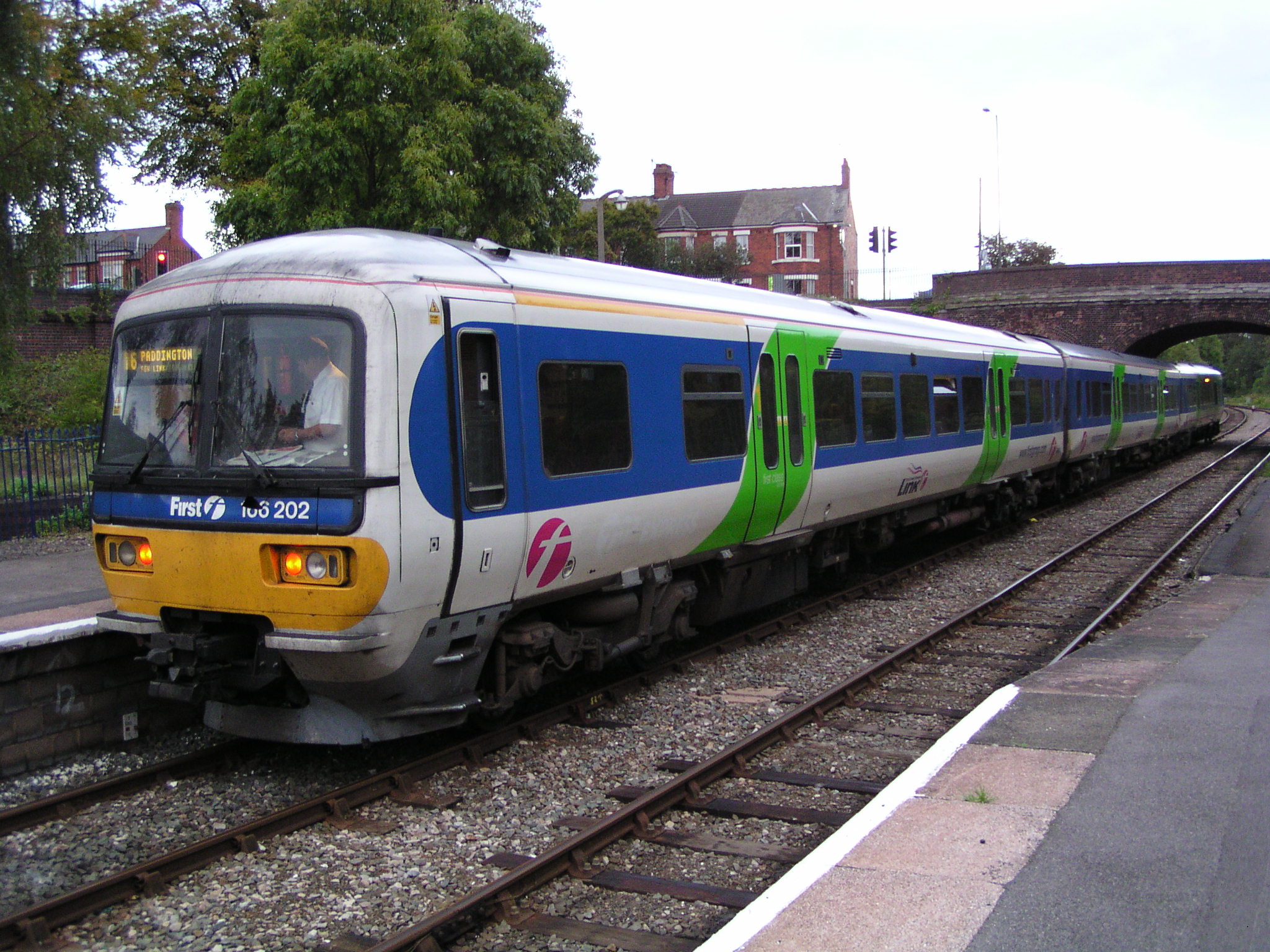
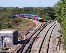 An HST leaving the Cotswold Line at Wolvercot Junction, about 3 miles (5 km) north of Oxford.
The line now turns west; here the former Buckinghamshire Junction Railway link with the Buckinghamshire Railway used to converge from the east. About 4 miles (6.4 km) after Oxford station, Yarnton station was in the short stretch between here and where the Witney Railway diverged to the south-west.[8] So far, the line has been close to the River Thames but the river now swings away to the south through a landscape dotted with gravel pits. The line now climbs the valley of the River Evenlode repeatedly crossing and re-crossing the river. Hanborough station serves the villages of Long Hanborough, Church Hanborough, Freeland and Bladon. The Oxford Bus Museum is next to Hanborough station.[9]
From Hanborough the line enters the Cotswold Area of Outstanding Natural Beauty and 1 mile (1.6 km) beyond Hanborough is Combe station. Building the line through Combe was difficult with several deep cuttings, four crossings of the Evenlode, and the diversion of a length of the river. To the south, just after the third river crossing are the remains of North Leigh Roman Villa. About 1 mile (1.6 km) beyond the villa the line crosses the course of Akeman Street Roman road. The Oxfordshire Way long-distance footpath follows Akeman Street from the north east to a point about 0.6 miles (1 km) north of the railway before turning to run through Stonesfield and meet the line at Charlbury station. The next station is Finstock. Between Finstock and Charlbury the deer park to the west of the line is Cornbury Park, venue for the Cornbury Music Festival. The woodlands south west of the park are the remains of Wychwood Forest named after the Hwicce, one of the Anglo-Saxon peoples of Britain. Charlbury station is the start of the redoubled track and is first stop for faster trains over the line and retains its original Oxford, Worcester and Wolverhampton Railway clapperboard building. Sir Peter Parker lived nearby at Minster Lovell and was a regular user of Charlbury station while chairman of the British Railways Board (1976 to 1983). The patronage of the head of the organisation may have helped to save the line at a time when the Serpell Report was calling for more rail closures.[10]
Charlbury to Moreton-in-Marsh
The line is now heading south-west and the site of Ascot d'Oilly Castle is to the north-west as the train enters Ascott-under-Wychwood. Few trains call at Ascott-under-Wychwood station, but there is a signal box controlling the level crossing and the points that were formerly the end of the single track section from Wolvercot Junction. 1.2 miles (1.9 km) beyond Ascott is Shipton station which serves the villages of Shipton-under-Wychwood, Milton-under-Wychwood and Fifield.
Still following the Evenlode, the line now turns north-west. There is another level crossing near Bruern Abbey. The next junction on the line was at Kingham from where the Banbury and Cheltenham Direct Railway went west to Cheltenham via Stow-on-the-Wold and east to King's Sutton near Banbury. Kingham village is north of the station. The village west of the station is Bledington. The Oxfordshire Way which has been close to the railway since Akeman Street now turns west to Bourton-on-the-Water but it is replaced by another long distance footpath, the Diamond Way. At Moreton-in-Marsh the line crosses the course of another major Roman road, the Fosse Way which linked Isca Dumnoniorum (Exeter) and Lindum Colonia (Lincoln). Moreton-in-Marsh was the headquarters of the railway spot-hire company Cotswold Rail until the company moved to Gloucester.
Moreton-in-Marsh to Hereford
 A First Great Western Link Network Express Turbo unit at Evesham station on 19 September 2004, with a service for London Paddington
About 28 miles (45 km) after Oxford is Moreton-in-Marsh. This was once the southern end of the Stratford and Moreton Tramway. The line then passes the corner of the Roman town of Dorn.[11] The Cotswold Line leaves the Evenlode which drains into the Thames and enters the catchment of the River Severn. The first level crossing appears. The building west of the crossing is a brick works and the neighbouring pits were the site of Jurassic clay extraction for the works. The village to the north is Paxford. The large country house to the west is Northwick Park, former home of Edward Spencer-Churchill and site of a United States Army hospital during World War II and afterwards a centre for Polish refugees. The line the passes the site of Chipping Campden station, about 1 mile (1.6 km) east of Chipping Campden itself. From here the line goes into cutting, then the 887 yards (811 m) Campden Tunnel under the Cotswold escarpment. In 1851 unrest among the navvies building the tunnel resulted in a riot — the 'Battle of Campden Tunnel'.[citation needed]
The next station is Honeybourne. From 1905 until 1977 this was the junction with the GWR line between Cheltenham and Stratford-upon-Avon. The track to the north remains as a link to the large former military depot at Long Marston. The large compound to the north with high walls, chapel, and floodlights is Long Lartin prison. There is another level crossing, where Littleton and Badsey station used to be. The line crosses the River Avon into Evesham. Opposite Evesham's Cotswold Line station is the former Midland Railway station, once on the Ashchurch & Barnt Green line. The line becomes single track again about 1 mile (1.6 km) west of Evesham and then crosses the River Avon again and follows it towards Pershore.
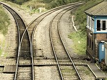 The site of Norton Junction looking towards Oxford. The single tracked Cotswold Line branches off to the left, with the right hand branch linking to the Cross Country Route (southbound).
The line crosses over the Cross Country Route and then passes through Norton Junction where there was formerly a station. The junction links the line to the Cross Country Route. Here double track starts. Where the two routes cross is where the proposed Worcester (Norton Parkway station would be built.
About 57 miles (92 km) after Oxford is Worcester Shrub Hill station. Here are connections to commuter lines going to Birmingham New Street. If Worcester (Norton) Parkway is built Shrub Hill station will be closed.[citation needed] Worcester Foregate Street station gives connections to the city centre and other lines to Birmingham. 6 miles (10 km) later the line reaches Malvern Link station. Great Malvern station follows, and 2 miles (3 km) later is the site of the former Malvern Wells station. After Malvern Wells the line enters the 1,584 yards (1,448 m) long Colwall New Tunnel. This is the second Colwall tunnel; the entrance to the original tunnel can be seen to the north. When the tunnel is below the ridge of the Malvern Hills, the line crosses the boundary between Worcestershire and Herefordshire. The line reaches Colwall station, where The Coca-Cola Company plant next to the station bottles Malvern Water, a local mineral water. Next to the bridge carrying the B4218 road over the railway is an unusual five-sided cottage.[citation needed] When the railway was built one corner had to be demolished and replaced by a plain wall. After the plant, Ledbury station is passed and Hereford station ends the journey on the line.
Usage
The busiest stations on this line are the city stations at Oxford, Worcester and Hereford, all of which are showing strong growth. Strong growth is also showing at intermediate stations between Worcester and Hereford whilst those between Worcester and Oxford are mainly in decline.[12]
The annual passenger usage is based on sales of tickets in stated financial years from Office of Rail Regulation statistics. The statistics are for passengers arriving and departing from each station and cover twelve month periods that start in April. Please note that methodology may vary year on year.
Station Name 2002-2003 2004-2005 2005-2006 2006-2007 2007-2008 2008-2009 2009-2010 Oxford 3,648,550 3,956,477 4,076,814 4,540,878 4,712,647 5,080,934 5,427,286 Hanborough 69,997 75,976 70,562 76,580 83,976 105,290 104,050 Combe (Oxfordshire) 1,548 2,037 2,591 2,612 2,042 2,120 1,836 Finstock 1,799 1,055 1,297 1,157 1,095 1,022 1,458 Charlbury 229,000 236,749 232,040 249,781 239,426 238,918 231,582 Ascott-under-Wychwood 2,050 2,534 2,931 1,769 2,499 2,860 2,264 Shipton 5,057 6,231 5,513 5,389 3,914 3,032 2,890 Kingham 121,318 124,462 126,995 131,183 141,310 147,554 137,944 Moreton-in-Marsh 176,389 180,458 178,004 189,230 176,502 185,284 178,040 Honeybourne 18,691 22,077 27,752 34,281 33,127 37,350 35,052 Evesham 240,174 269,474 239,257 236,611 214,364 207,998 203,578 Pershore 50,949 53,154 62,522 61,739 61,971 62,472 58,744 Worcester Shrub Hill 1,225,757 1,355,790 202,708 592,756 625,971 761,666 856,196 Worcester Foregate Street 379,734 319,996 1,582,620 1,273,385 1,252,182 1,469,283 1,487,256 Malvern Link 165,820 179,091 201,091 216,790 227,141 235,748 249,898 Great Malvern 394,411 373,914 392,143 405,371 384,906 447,172 464,296 Colwall 43,788 40,574 44,596 51,392 56,384 56,528 63,062 Ledbury 133,968 130,403 135,033 147,496 162,588 180,136 184,340 Hereford 602,219 732,320 800,448 854,475 899,199 974,844 974,668 References
- ^ Oxford Mail
- ^ http://www.firstgreatwestern.co.uk/Content.aspx?id=3501 FGW's website
- ^ Network Rail Leaflet
- ^ this is oxfordshire website
- ^ "Railway Magazine", July 1959
- ^ "Railway Magazine", August 1959
- ^ Draft Milton Keynes & South Midlands Sub-Regional Strategy
- ^ Yarnton Junction
- ^ Oxford Bus Museum
- ^ Serpell Report
- ^ Dorn
- ^ "Station Usage". Rail Statistics. Office of Rail Regulation. http://www.rail-reg.gov.uk/server/show/nav.1529.
Soruces and further reading
- Atterbury, Paul (1989). See Britain by Train. AA Publishing. pp. not cited. ISBN 0-86145-760-9.
- Connolly, W. Philip (1976). British Railways Pre-Grouping Atlas and Gazetteer. Shepperton: Ian Allan Publishing. ISBN 0 7110 0320 3.
- Dewick, Tony (2002). Complete Atlas of Railway Station Names. Hersham: Ian Allan Publishing. ISBN 0 7110 2798 6.
- New Adlestrop Railway Atlas.
External links
- The Cotswold Line Promotion Group is a voluntary organisation with the aim of safeguarding and promoting improvements to rail and bus feeder services along the line.
- Hansard for 3 March 2004 — Record of House of Commons adjournment debate on the Cotswold Line.
- The Cotswold Line Railbus bus routes, with revenue support from Oxfordshire County Council, link the Wychwood villages (Milton, Shipton and Ascott), Leafield and Finstock to Charlbury station (routes C1/T1) and Chipping Norton, Churchill, Kingham, Foscot, Idbury, Fifield, and the Wychwoods to Kingham station (route X8). Since February 2009 there has also been a Sunday service on route 233 between Chipping Norton, Kingham station, the Wychwoods, Burford, and Witney.
Railway lines in the West Midlands Primary 
Secondary Local Birmingham to Peterborough Line · Birmingham to Stratford Line · Birmingham to Worcester via Bromsgrove Line · Birmingham to Worcester via Kidderminster Line · South Staffordshire Line · Chase Line · Cotswold Line · Coventry to Leamington Line · Coventry to Nuneaton Line · Crewe-Derby Line · Cross-City Line · Leamington to Stratford Line · Northampton Loop Line · Rugby–Birmingham–Stafford Line · Shrewsbury to Chester Line · Stafford to Manchester Line · Stourbridge Town Branch Line · Walsall to Wolverhampton Line · Welsh Marches Line · Wolverhampton to Shrewsbury LineRailway lines in the South West Primary 
Secondary Local Atlantic Coast Line · Avocet Line · Bristol to Taunton Line · Cornish Main Line · Cotswold Line · Gloucester to Newport Line · Golden Valley Line · Heart of Wessex Line · Henbury Loop · Looe Valley Line · Lostwithiel to Fowey · Maritime Line · Portishead Branch · Riviera Line · Severn Beach Line · St Ives Bay Line · Tamar Valley Line · Tarka Line · Wessex Main LineHeritage Avon Valley Railway · Bristol Harbour Railway · Bodmin and Wadebridge Railway · Helston Railway · East Somerset Railway · Dartmoor Railway · Paignton and Dartmouth Steam Railway · South Devon Railway · West Somerset RailwayTransport in Worcestershire Road Motorways A-Roads Service Stations Other Rail Main lines Closed lines Stations Closed stations Astwood Bank • Aston-under-Hill • Beckford • Bengeworth • Foley Park Halt • Hinton • Littleton and Badsey • Malvern Wells • Ripple • Upton-on-SevernHeritage stations Other Buses Routes List of bus routes in Worcestershire • Worcestershire bus route 144 • West Midlands Bristol Road bus corridorCompanies Other Bus transport in BromsgroveWaterways Rivers Canals Other Footpaths Long-distance footpaths Cycle Paths Categories:- Rail transport in Oxfordshire
- Rail transport in Gloucestershire
- Rail transport in Worcestershire
- Rail transport in Herefordshire
- Railway lines in South East England
- Transport in Oxford
- Transport in Worcester
- Hereford
- Railway lines opened in 1851
- Railway lines in South West England
- Railway lines in the West Midlands (region)
- Cotswolds

Wikimedia Foundation. 2010.