- Maidstone East Line
-
Maidstone East Line 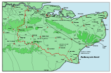
Swanley to Ashford (via Maidstone East) Line, shown with other railway lines in Kent.Overview Type Suburban rail, Heavy rail System National Rail Status Operational Locale Kent
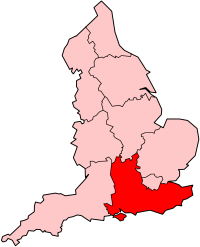
South East EnglandOperation Owner Network Rail Operator(s) Southeastern Technical Track gauge 1,435 mm (4 ft 8 1⁄2 in) Standard gauge Maidstone East Line (Swanley to Ashford) LegendSwanley 


Chatham Main Line 

A20 18m 60ch 
M25 
Eynsford Tunnel 19m 36ch 
Lullingstone (never opened) Eynsford Viaduct 
River Darent 20m 32ch 
Eynsford 22m 52ch Shoreham 24m 06ch 
Otford 24m 53ch 
M26 Bat & Ball spur 

Bat & Ball 
SEML (To London) 


Sevenoaks SEMLTo Tunbridge Wells 
26m 79ch Kemsing 29m 52ch Borough Green & Wrotham 34m 61ch West Malling 35m 64ch East Malling 37m 43ch Barming 
Medway Valley Line River Medway 39m 76ch Maidstone East Wheeler Street Tunnel (358 yds) 42m 59ch Bearsted M20 High Speed 1 
45m 02ch Hollingbourne 47m 36ch Harrietsham 49m 11ch Lenham 53m 11ch Charing M20 55m 61ch Hothfield closed 1959 LCDR Ashford High Speed 1 
SEML 59m 19ch Ashford International High Speed 1 
Ashford to Ramsgate (via Canterbury West) line Marshlink Line SEML
The Maidstone East Line diverges from the Chatham Main Line at Swanley Junction (after Swanley), proceeds down the Darenth valley (via a Tunnel to Eynsford) where the line diverges off the Sevenoaks line (via Bat and Ball) at Otford. It continues via Borough Green & Wrotham to Maidstone East, which leads onto Ashford and on to east Kent. The line is double track throughout.The line from Swanley to Maidstone East was electrified using the third rail system in 1939. The section between Maidstone East and Ashford was electrified in 1961.
History
The line was built by the London, Chatham and Dover Railway from their first line (the Chatham Main Line). Upon the creation of the South Eastern and Chatham Railway the original Ashford terminus was closed in 1899 and services diverted to the South Eastern Railway's Ashford station. The line was electrified in 1939 (750V DC third rail) to Maidstone East by the Southern Railway prior to World War Two. Electrification between Maidstone East and Ashford was completed in 1961 under the BR 1955 Modernisation Plan.
Services
Services on the line are run by Southeastern. Services run to London Victoria and Ashford, with some peak services to Bedford via London Blackfriars.
Due to its place between the two main lines through Kent (South Eastern Main Line and Chatham Main Line), the line has comparatively infrequent services and longer journey times.
References
- Yonge, John (October 1994). Gerald Jacobs. ed. Railway Track Diagrams - Volume 5 England, South and London Underground (1st edition ed.). Exeter: Quail Map Co.. ISBN 1-8983-1907-3.
- Yonge, John (2002). Gerald Jacobs. ed. Railway Track Diagams - Book 5: England South and London Underground (Quail Track Plans) (2nd edition ed.). Exeter: Quail Map Company. ISBN 1-8983-1952-9. OCLC 55557335.
Categories:- Rail transport in Kent
- Transport in Ashford, Kent
- Railway lines in South East England
- Standard gauge railways in England

Wikimedia Foundation. 2010.