- Cornish Main Line
-
Cornish Main Line 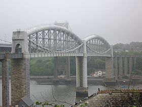
The Royal Albert BridgeOverview Type Heavy rail System National Rail Status Operational Locale Cornwall, United Kingdom Termini Plymouth
PenzanceOperation Opened 1867 Owner Network Rail Operator(s) First Great Western
CrossCountry
(Freight: DB Schenker & Freightliner)Technical Line length 79.5 miles (128 km) No. of tracks Double with two single track sections Track gauge Standard Gauge 1,435 mm (4 ft 8 1⁄2 in) Operating speed 65 mph (105 km/h) The Cornish Main Line is a railway line in the United Kingdom, which forms the backbone for rail services in Cornwall, as well as providing a direct line to London.
Contents
History
The line was completed in 1859 with the opening of the Cornwall Railway from Plymouth to Truro, where it linked with the earlier West Cornwall Railway on to Penzance. There were no through passenger services until 1867 due to a break of gauge at Truro – the Cornwall Railway had been built to the 7 ft 0 1⁄4 in (2,140 mm) broad gauge, while the older line was to 4 ft 8 1⁄2 in (1,435 mm) standard gauge.[1]
Route
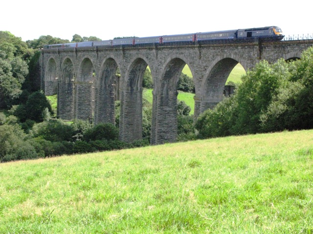
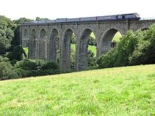 A London to Penzance train crosses Moorswater Viaduct
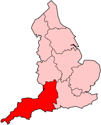
The communities served are: Plymouth (including the suburbs of Devonport and St Budeaux); Saltash; St Germans; Menheniot; Liskeard; Bodmin; Lostwithiel; Par; St Austell; Truro; Redruth; Camborne; Hayle; St Erth; Penzance. In addition branch lines link Plymouth with Bere Alston, Calstock, and Gunnislake; Liskeard with Looe; Par with Newquay; Truro with Penryn and Falmouth; and St Erth with St Ives.
The railway stations at St Austell and Penzance are adjacent to bus stations. In addition, integrated bus services operate from Bodmin Parkway to Bodmin, Wadebridge, and Padstow; from St Austell to The Eden Project; and from Redruth to Helston and RNAS Culdrose.
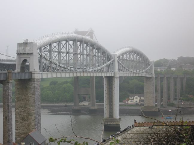
The route is characterised by the large number of viaducts, but the most significant structure is the Royal Albert Bridge[2] which crosses the River Tamar at Saltash. At Truro the viaducts give sweeping views of the city and River Fal, while further west the north coast can be seen near Hayle before the line swings onto the south coast for the last mile or so along the beach at Marazion, giving a good view of St Michael's Mount.
The 7.5-mile (12.1 km) section of single track between Burngullow, near St Austell, and Probus, near Truro, used to be a major cause of delays in the region, requiring trains to wait for preceding trains to clear the singled section before proceeding. The second track was restored in August 2004. The total cost of the project was £14.3 million and was funded by Objective One, Strategic Rail Authority and Cornwall County Council.
Usage
Cornish Main Line Legend
miles from London via Castle Cary 
Main Line to London 
225.75 Plymouth 


Plymouth Millbay 


Millbay Docks 
Pennycomequick Viaduct 

Cornwall Loop Junction 
Devonport Junction (to LSWR) 
Wingfield Villas Halt 


Devonport Kings Road (LSWR) 
Stonehouse Pool Docks 
227.00 Devonport 
Albert Road Halt (LSWR) 


Devonport Tunnel 227.50 Dockyard Keyham Viaduct Ford (LSWR) Ford Platform 228.00 Keyham 


Devonport Dockyard branch Camels Head Halt (LSWR) 
Weston Mill Viaduct 
Bullpoint Siding 

Weston Mill Halt (LSWR) 
228.75 St Budeaux Ferry Road St Budeaux Victoria Road 


Tamar Valley Line 

Royal Albert Bridge (River Tamar) 230.00 Saltash Coombe by Saltash Viaduct Defiance Platform Original line until 1906 Forder Viaduct Shilingham (Wivelscombe) Tunnel Grove Viaduct Nottar Viaduct 
St Germans Viaduct 235.00 St Germans 
Tresulgan Viadcut Coldrennick Viaduct 240.25 Menheniot Treviddo Viaduct Carthuther Viaduct Bolitho Viaduct 
Liskeard Viaduct 
243.50 Liskeard 
Looe Valley Line Coombe Junction Halt 
Moorswater depot and Viaduct 
Sperritt Tunnel Westwood Viaduct St Pinnock Viaduct Largin Viaduct West Largin Viaduct Derrycombe Viaduct Clinnick Viaduct Penadlake Viaduct 
Glyn Valley Siding 252.75 Bodmin Parkway 
Bodmin and Wenford Railway Brownqueen Tunnel (88 yards) 
Lostwithiel 256.00 Lostwithiel River Fowey Fowey Branch Milltown Viaduct Treverrin Tunnel (565 yards) 260.50 Par 
Atlantic Coast Line 
St Blazey Par Harbour 265.00 St Austell St Austell Viaduct 

Lansalson branch line Trenance Siding Gover Viaduct Burngullow Drinnick Mill Branch Burngullow Coombe St Stephen Viaduct Fal Viaduct Grampound Road Probus and Ladock Tregagle Viaduct Polperro Tunnel Buckshead Tunnel Truro Viaduct Carvedras Viaduct 
Truro (Newham) 279.50 Truro Higher Town Tunnel 

Maritime Line Chacewater Viaduct Chacewater 
Truro and Newquay Railway Scorrier Drump Lane Redruth Tunnel 288.50 Redruth Redruth Viaduct 

Redruth & Tresavean branches Portreath branch Carn Brea Dulcoath Dolcoath Halt Roskear Branch Roskear Junction 292.00 Camborne Penponds Viaduct 
Helston Railway Penponds Gwinear Road Original Hayle Railway route to Hayle Angarrack viaduct Angarrack Copperhouse Halt 298.00 Hayle 
Hayle Wharves Hayle Viaduct St Ives Bay Line 299.50 St Erth Marazion Long Rock Penzance TMD 
305.25 Penzance The number of passengers travelling on the Cornish Main Line has increased in the last few years up to 2006-2007, with the exception of Keyham, Menheniot and St Erth. These three stations saw usage drop, with the biggest drop being at St Erth. During the period 2007-2008, most stations saw a general increase in usage except for most of the Plymouth stations, Saltash and Hayle. Truro in particular had nearly a million people.[3] The annual passenger usage is based on sales of tickets in stated financial years from Office of Rail Regulation statistics. The statistics are for passengers arriving and departing from each station and cover twelve month periods that start in April. Please note that methodology may vary year on year.
Station Name 2002-2003 2004-2005 2005-2006 2006-2007 2007-2008 2008-2009 2009-2010 Plymouth 1,431,674 1,519,011 1,629,011 1,845,958 2,026,851 2,249,849 2,278,718 Dockyard 4,070 5,088 4,895 5,335 4,924 5,274 5,524 Keyham 8,957 6,374 7,594 7,976 5,055 5,600 5,016 St Budeaux Ferry Road 987 969 1,015 1,037 1,199 1,132 1,540 Saltash 27,197 35,349 32,186 34,266 32,062 47,244 49,578 St Germans 25,681 24,926 28,228 29,540 29,073 37,718 38,258 Menheniot 6,554 5,782 4,453 4,206 3,610 4,598 3,844 Liskeard 209,875 232,269 237,113 267,864 274,090 294,638 Bodmin Parkway 144,146 158,172 166,743 185,498 203,061 225,140 221,616 Lostwithiel 40,701 42,602 46,172 46,645 51,695 61,716 68,336 Par 78,175 95,475 111,912 119,859 139,688 160,832 162,872 St Austell 266,676 275,056 281,545 314,613 360,484 388,878 395,222 Truro 638,727 714,954 772,674 856,474 917,184 997,368 1,042,412 Redruth 186,977 219,013 228,511 258,384 277,853 292,940 284,462 Camborne 109,628 146,595 157,026 181,671 193,948 215,600 224,950 Hayle 34,802 43,467 51,299 63,593 60,174 73,868 77,172 St Erth 71,406 90,541 88,341 67,004 68,230 75,026 75,248 Penzance 392,008 403,000 413,905 461,764 498,290 526,132 520,982 The statistics cover twelve month periods that start in April.
Accidents
The Cornwall Main Line has been a very safe railway for passengers, although a number of railwaymen have been killed and there have been some memorable accidents over the years. These include:
- Grove Viaduct, St Germans – derailment, 6 May 1859.
- St Austell – runaway train, 29 October 1872.
- Menheniot – collision, 2 December 1873.
- Bodmin Road – derailment, 13 April 1895.
References
Notes
- ^ MacDermot, E T (1931). History of the Great Western Railway, volume II 1863-1921. London: Great Western Railway.
- ^ Binding, John (1997). Brunel's Royal Albert Bridge. Truro: Twelveheads Press. ISBN 0-906294-39-8.
- ^ "Station Usage". Rail Statistics. Office of Rail Regulation. http://www.rail-reg.gov.uk/server/show/nav.1529. Retrieved 2009-03-20.
Further reading
- Bennett, Alan (1990). The Great Western Railway in East Cornwall. Cheltenham: Runpast Publishing. ISBN 1-870754-11-5.
- Bennett, Alan (1988). The Great Western Railway in Mid Cornwall. Southampton: Kingfisher Railway Publications. ISBN 0-946184-53-4.
- Bennett, Alan (1988). The Great Western Railway in West Cornwall. Cheltenham: Runpast Publishing. doi:1990. ISBN 1-870754-12-3.
- Binding, John (1993). Brunel's Cornish Viaducts. Penryn: Atlantic Transport Publishing/Historical Model Railway Society. ISBN 0-906899-56-7.
- Hesp, Martin (2008). "My magnificent rail journey". Western Morning News. Western Morning News. doi:2008-07-07. http://www.thisisplymouth.co.uk/news/magnificent-rail-journey/article-209062-detail/article.html. Retrieved 2008-07-14.
See also
- Cornwall Railway
- Cornwall Railway viaducts
- Disused railway stations (Plymouth to Penzance Line)
- Great Western Main Line
- West Cornwall Railway
Railway lines in the South West Primary 
Secondary Local Atlantic Coast Line · Avocet Line · Bristol to Taunton Line · Cornish Main Line · Cotswold Line · Gloucester to Newport Line · Golden Valley Line · Heart of Wessex Line · Henbury Loop · Looe Valley Line · Lostwithiel to Fowey · Maritime Line · Portishead Branch · Riviera Line · Severn Beach Line · St Ives Bay Line · Tamar Valley Line · Tarka Line · Wessex Main LineHeritage Avon Valley Railway · Bristol Harbour Railway · Bodmin and Wadebridge Railway · Helston Railway · East Somerset Railway · Dartmoor Railway · Paignton and Dartmouth Steam Railway · South Devon Railway · West Somerset RailwayCategories:- Rail transport in Cornwall
- Railway lines in South West England
- Standard gauge railways in England
Wikimedia Foundation. 2010.