- Royal Albert Bridge
Infobox Bridge
bridge_name = Royal Albert Bridge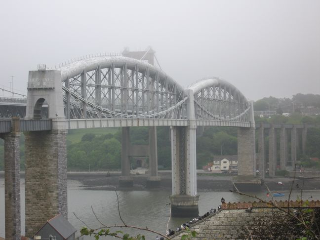
caption = The view fromSaltash railway station before the walkways were removed from the end of the bridge in 2006.
carries = Railway
crosses =River Tamar
locale =Saltash ,United Kingdom
maint =Network Rail
designer = I K Brunel
design = Lenticular truss
material = Iron
spans = 19
pierswater = 3
mainspan = 2 of convert|455|ft|m|1
length = convert|2187.5|ft|m
width = convert|16.83|ft|m (inside piers)
height = convert|172|ft|m|1
below = convert|100|ft|m
begin = May 1854
complete = April 1859
open =2 May 1859
lat = 50.407575
long = -4.203389The Royal Albert Bridge (sometimes called the Brunel Bridge or Saltash Bridge) spans the
River Tamar in theUnited Kingdom betweenPlymouth , on theDevon bank, andSaltash on the Cornish bank. It was designed byIsambard Kingdom Brunel and carries theCornish Main Line in and out of Cornwall. It was opened by Prince Albert on2 May 1859 , the year of Brunel's death.Close alongside on the north of the Royal Albert Bridge is the
Tamar Bridge carrying the A38, one of the twotrunk road s connecting Cornwall to Devon.Cornwall Railway
Two rival schemes for a railway to
Falmouth, Cornwall were proposed in the 1830s. The 'central' scheme was a route fromExeter around the north ofDartmoor , an easy route to construct but with little intermediate traffic. The other, the 'coastal' scheme, was a line with many engineering difficulties but which could serve the important naval town ofPlymouth and the industrial area aroundSt Austell . The central scheme was backed by theLondon and South Western Railway while the coastal scheme was supported by theCornwall Railway and backed by theGreat Western Railway which wanted it to join up with the South Devon Railway at Devonport. The Cornwall Railway applied for anAct of Parliament in 1845 but it was rejected, in part because ofWilliam Moorsom 's plan to carry trains across the water of theHamoaze on theTorpoint Ferry . Following this Isambard Kingdom Brunel took over as engineer and proposed to cross the water higher upsteam at Saltash. The Act enabling this scheme was passed on3 August 1846 . [cite book| last = Ostler| first = Edward| title = History of the Cornwall Railway 1835-1846| publisher = Avon-Anglia| date = 1982| location = Weston-super-Mare| id = ISBN 0-90546-648-9]Design
The structure was the third in a series of three large
wrought iron bridges built in the middle of thenineteenth century and was influenced by the preceding two, both of which had been designed byRobert Stephenson . The two central sections of Brunel's bridge are novel adaptations of the design Stephenson employed for theHigh Level Bridge across theRiver Tyne inNewcastle Upon Tyne in 1849. Brunel was present when Stephenson raised the girders of hisBritannia Bridge across theMenai Strait in the same year. [cite book|last = Norrie|first = Charles Matthew|title = Bridging the Years - a short history of British Civil Engineering|publisher = Edward Arnold (Publishers) Ltd|date = 1956|] From 1849 to 1853 was Brunel erecting an iron bridge of his own. TheChepstow Bridge carried theSouth Wales Railway across theRiver Wye and featured a main truss of convert|300|ft|m with a curving tubular main member, and three conventional plate-girder approach spans of convert|100|ft|m, a similar solution to that adopted for crossing theRiver Tamar at Saltash.cite book|last = Binding|first = John|title = Brunel's Royal Albert Bridge|publisher = Twelveheads Press|date = 1997|location = Truro|id = ISBN 0-90629-439-8]The river is about convert|1100|ft|m wide at Saltash. Brunel's first thoughts had been to cross this on a timber viaduct with a central span of convert|255|ft|m and six approach spans of convert|105|ft|m with convert|80|ft|m clearance above the water. This was rejected by the Admiralty, who had statutory responsibility for navigable waters, and Brunel thus produced a design to give convert|100|ft|m clearance, with two spans of convert|300|ft|m and two of convert|200|ft|m.cite book| last = MacDermot| first = E T| title = History of the Great Western Railway, volume II 1863-1921| publisher =
Great Western Railway | date = 1931| location = London] The final design as built consists of two main iron spans of convert|455|ft|m|1 with convert|100|ft|m|1 clearance above mean highspring tide . These two spans are lenticular trusses with the top chord of each truss comprising a heavy tubular arch in compression, while the bottom chord comprises a pair chains. Each of the trusses is simply supported and therefore no horizontal thrust is exerted on the piers. Between these two chords are supporting cross-bracing members and suspension standards which hang beneath the bottom chord to carry the railway deck which is a continuous plate beam. There are also seventeen much shorter and more conventional plate-girder approach spans on the shore. On the Cornish side there are ten which measure (from Saltash station towards the river): convert|67.5|ft|m, convert|69.5|ft|m, convert|69.5|ft|m, convert|69.5|ft|m, convert|69.5|ft|m, convert|69.5|ft|m, convert|72.5|ft|m, convert|78.0|ft|m, convert|83.5|ft|m, convert|93.0|ft|m, and seven on the Devon side of (from the river towards St Budeaux): convert|93.0|ft|m, convert|83.5|ft|m, convert|78.0|ft|m, convert|72.5|ft|m, convert|69.5|ft|m, convert|69.5|ft|m, convert|69.5|ft|m. This gives a total length for the nineteen spans of convert|2187.5|ft|m.Construction
The first work was to properly survey the river bed. On
26 April 1848 a convert|6|ft|m|1 iron cylinder convert|85|ft|m|1 tall was launched into the Tamar. From the bottom of this the bed of the river could be examined to identify its nature and the location of solid foundations. The Cornwall Railway at this time was finding it difficult to raise funds and so most operations were suspended that summer, but a small fund was allowed for Brunel to continue the survey. The cylinder was positioned at 35 different places and a total of 175 borings made.In 1853 the tenders for the bridge were considered by the Cornwall Railway Board, and it was decided to let the work to
Charles Mare , a shipbuilder fromBlackwall who had built the ironwork for the Britannia Bridge. The fee he sought for building the Saltash Bridge was £162,000, but on21 September 1855 he filed for bankruptcy. Brunel proposed that the company should take over the works on the bridge without engaging another contractor, to which the company agreed.Mare's first task had been to establish an erecting yard on the Devon shore with a jetty and workshops. He then proceeded to construct a convert|37|ft|m|1 iron cylinder convert|90|ft|m|1 tall which was to form the work base for the construction of the central pier. This was launched in May 1854 and moored in the centre of the river between four pontoons. The bottom had been shaped to follow the rock surveyed in 1848; once it was settled on the river bed the water was pumped out, the mud within it excavated, and a solid masonry pier built up clear of the water. This was completed in November 1856.
The landward piers on the Cornish side of the river were completed in 1854 and the girders for these spans were hoisted up to their correct positions. Next to be built was the main truss for the Cornwall side of the river. The lower ties of the trusses formed of chains made from convert|20|ft|m|1 links. Many were obtained from the suspended works for Brunel's
Clifton Suspension Bridge and others rolled new for Saltash. The Cornwall span was floated into position on1 September 1857 and jacked up to full height in convert|3|ft|mm stages as the piers were built up beneath it, the central pier using cast iron octagonal columns; the landward one using ordinary masonry.With the yard now cleared of the first truss, work could start on the main Devon span. This was similarly floated into position on
10 July 1858 and then raised in a similar manner; it was in its final position by28 December 1858 . After this had been removed, part of the yard had to be cleared to allow the construction of the final landward pier and then the Devon approach spans could be raised up to their final position. The work was sufficiently advanced that directors were able to make an inspection by train on11 April 1859 .The Cornwall span had been tested before it was launched. The two ends were supported on substantial timber piers and the remaining scaffolding removed. Static loads of 1.25 and then 2.25 tons per foot were placed on the deck, the deflections measured and any permanent change measured once the road was removed. Now that it was completed, the bridge ahd its statutory inspection and tests by Colonel Yolland on behalf of the
Board of Trade on20 April 1859 . He ran a heavy train over the bridge and measured deflections in the main trusses of convert|1.14|in|mm|0 in the Devon truss, and convert|1.20|in|mm|0 in the Cornwall one. Overall he described it as 'highly satisfactory'.Opening day
Prince Albert had agreed to the bridge being named after him as early as 1853. He was also invited to perform the opening ceremony and so on
2 May 1859 he travelled down fromWindsor on a special train. Several thousand spectators attended that day but Brunel was not there due to illness,cite book| last = Bennett| first = Alan| title = The Great Western Railway in East Cornwall| publisher = Runpast Publishing| date = 1990| location = Cheltenham| id = ISBN 1-870754-11-5] and guests from Cornwall failed to arrive in time for the ceremony as their train broke down at Liskeard. [cite journal| title = Illustrated Railway Supplement| journal = West Briton & Cornwall Advertiser| issue = 2547| date = 1859| accessdate = ] Public services commenced on4 May 1859 .Changes since 1859
The words "I.K. BRUNEL, ENGINEER, 1859" appear in large metal letters on either end of the bridge, added as a memorial after his death on
5 September 1859 . In 1921, new access platforms were added that obscured the lettering but in 2006Network Rail relocated the platforms, allowing the name to be clearly seen again. [cite web|title = Brunel's Royal Albert Bridge unveiled in all its splendour|publisher =Network Rail |url = http://www.networkrailmediacentre.co.uk/Content/Detail.asp?ReleaseID=1840&NewsAreaID=17&SearchCategoryID=-1|accessdate=2006-05-16] The walkways had previously been temporarily removed in 1959 and the bridge floodlit during its centenary year.401 new cross-girders were fitted in 1905 to allow heavier locomotives to pass over. In 1908 the two spans nearest
Saltash railway station were replaced with wider ones to accommodate a new track layout. The remaining approach spans were replaced on both sides of the river during 1928 and 1929. During the 1930s new cross-bracing and diagonal sway-bracing were added between the vertical standards to further strengthen the birdge and keep the suspension chains hanging in the correct shape.Viewing the bridge
It is still possible to travel over the bridge by using a train on the
Cornish Main Line , and pass below it on the River Tamar. Cruise boats operate between Phoenix Wharf,Plymouth , Saltash, andCalstock . [cite web| title =Plymouth Boat Cruises| publisher =Sound Cruising| url = http://www.soundcruising.com/index.php?Act=Home| accessdate = 2008-07-16] There area also several view points around the bridge.*
Saltash railway station (coord|50.40719|N|4.20924|W|type:landmark_region:GB):The Cornish approach spans start right at the platform end. These were replaced in 1908 so that the single line on the bridge could split into two lines before reaching the station.
*Saltash Quay (coord|50.40779|N|4.20614|W|type:landmark_region:GB):The foreshore at Saltash runs right up to the pier that supports the Cornish end of the main span. An inscribed stone commemorating the bridge can be found beneath the bridge on the hillside alongside Fore Street.
*Tamar Bridge (coord|50.40777|N|4.19974|W|type:landmark_region:GB):The road bridge lies parallel to and slightly higher than the railway bridge on its north side. A toll-free foot and cycle path is situated on the south side of the road bridge from which it is possible to examine the bridge in detail. An area of grass beside the motor vehicletoll booth s affords a view of the Devon end of the railway bridge.
*St Budeaux Passage (coord|50.40585|N|4.20069|W|type:landmark_region:GB):The Devon piers can be reached from the waterfront at St Budeaux. The yard where the spans were constructed was situated alongside the bridge at the foot of the road down the hill.Cultural impact
The construction of such a large and distinctive bridge soon caught the attention of the general public. The launching of the Cornish span in 1857 attracted a crowd of around 20,000, and many people also came to witness the launch of the Devon span and the opening day. During its construction it was photographed many times and after its opening it was the subject for many paintings, including those by local artist
Alfred Wallis . [cite web| last =Blair| first =Andy| title = Alfred Wallis: Artist & Mariner| url =http://www.alfredwallis.org.uk/| accessdate = 2009-07-15] . It has also been the subject of many photographs andpostcard s. [cite web| title =Saltash, South East Cornwall| work =The Magic of Cornwall| publisher =David Carvey| url =http://www.themagicofcornwall.com/pages/frith/locations/saltash_frith.htm| accessdate = 2008-07-18]It was already a feature guidebooks in the year of its opening: "It is a labour of
Hercules , but Mr Brunel has accomplished the feat" proclaimed one, and went on to report in detail the design and construction of the bridge that "for novelty and ingenuity of construction stands unrivalled in the world". [cite book| last = Murray| first = John| title = Murray's Handbook for Devon and Cornwall| publisher = John Murray | date = 1859| location = London ] More than 100 years later it continues to appear in many travel guides and features. [cite web| last =Hesp| first =Martin| title =My magnificent rail journey| work =Western Morning News| publisher =Western Morning News|url=http://www.thisisplymouth.co.uk/news/magnificent-rail-journey/article-209062-detail/article.html| date =2008| doi =2008-07-07| accessdate = 2008-07-14]John Betjeman summed up its impact on the traveller:::"The general grey slate and back gardens of Plymouth, as seen from the Great Western made the surprise of Saltash Bridge all the more exciting. Up and down stream, grey battleships were moored in the Tamar and its reaches. Hundreds of feet below, the pathetic steam ferry to Saltash from the Devon bank tried to compete with Brunel's mighty bridge." [cite book|last = Perry|first = George (editor)|title = 'The Book of the Great Western|publisher =Sunday Times Magazine|date = 1970|location = London|id = ISBN 0-72300-018-2]The bridge has become a symbol of the transition from Devon to Cornwall. In the Great Western Railway's "The Cornish Riviera" travel guide,
SPB Mais regarded it as "an almost magic means of transporting travellers from acounty , which, if richer than others, is yet unmistakingly an English county, to aDuchy which is in every respect un-English. You shut your eyes going over the Saltash Bridge only to open them again on a foreign scene". [cite book| last = Mais| first = SPB| authorlink = Petre Mais| title = The Cornish Riviera| publisher =Great Western Railway | date = 3rd ed. 1934| location = London] However, Cornish people look at it in the other way; in the song "Cousin Jack", English folk duoShow of Hands sing "I dream of a bridge on the Tamar, It opens us up to the East". [cite web| title =Cousin Jack Lyrics| publisher =Lyrics Mania| url =http://www.lyricsmania.com/lyrics/show_of_hands_lyrics_34604/other_lyrics_65491/cousin_jack_lyrics_644716.html| accessdate = 2008-07-15]References
Further reading
*cite web| last =Mosley| first =Brian| title =Royal Albert Bridge| work =Encyclopedia of Plymouth History| publisher =Plymouth Data| url =http://www.plymouthdata.info/Bridges-Royal%20Albert-Design.htm| accessdate = 2008-08-22
External links
* [http://www.royal-albert-bridge.co.uk The "Royal Albert Bridge" website]
* [http://www.royalalbertbridge.co.uk Brunel 200 - The Royal Albert Bridge]
*
* [http://www.brunel-museum.org.uk The Brunel Museum, Rotherhithe, London]
Wikimedia Foundation. 2010.