- St Austell railway station
Infobox UK station
name = St Austell
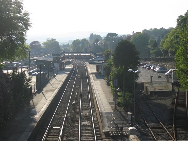
caption = Looking westwards at dusk
manager =First Great Western
locale =St Austell
borough =Restormel ,Cornwall
latitude = 50.3397
longitude = -4.79028
code = SAU
original =Cornwall Railway
pregroup =Great Western Railway
postgroup =Great Western Railway
years = 1859
events = Opened
years1 = 1931
events1 = Level crossing closed
years2 = 2000
events2 = Main building rebuilt
platforms = 2
lowusage0203 = 266,766
lowusage0405 = 275,056
lowusage0506 = 281,545
lowusage0607 = 314,613St Austell Station serves the town of
St Austell ,Cornwall , UK. The station is operated byFirst Great Western as is every other station in Cornwall.The station is situated on the hillside just above the town. The main buildings were rebuilt in 2000 and face the town's bus station. A dedicated bus service, the
Eden Branchline , runs from here toThe Eden Project .The station is served by both local and long-distance trains, including the
Night Riviera sleeper service. [cite web| title = National Rail Timetable 135| url = http://www.networkrail.co.uk/browse%20documents/eNRT/Dec07/timetables/Table135.pdf]History
St Austell opened with the
Cornwall Railway on4 May 1859 . [cite book | last = Clinker | first = CR | title = The Railways of Cornwall 1809 - 1963 | publisher = David and Charles | year = 1963 | location = Dawlish ] A report when the station opened stated that:"the departure station is an ornamental wooden structure, having projecting verandahs at each side, waiting room, ticket office, &c., similar to the corresponding building at Lostwithiel. Nearly opposite is the arrival station, which is built of stone, with projecting verandah over the platform and having convenient waiting, porters', and lamp rooms. To the south of this is the goods shed, a stone building of the same dimensions as the goods shed at Lostwithiel, and the provision has been made here, for the accommodation of the heavy goods traffic that is anticipated from the district. Amongst other arrangements adopted, with the view of preventing collisions and inconvenience, it has been determined that the passenger traffic shall pass to the station through a street in front of the post office, and the goods traffic by Menacuddle Hill, in front of the Town Hall." ["West Briton and Cornwall Advertiser", Railway Special Edition, 1859]The
goods shed was adjacent to the road which passed over the line on alevel crossing . This was not authorised by the originalAct of Parliament but was deemed unavoidable unless the road was given a very steep bridge to climb over the line. Palace Road was built along the back of the station in 1862 to make it possible for traffic from the east of the town to avoid the level crossing.Records of the Cornwall Railway inThe National Archives at Kew] The level crossing was finally closed on21 September 1931 .cite book | last = Bennett | first = Alan | title = The Great Western Railway in Mid Cornwall | publisher = Kingfisher Railway Publications | year = 1988 | location = Southampton | id = ISBN 0-94618-453-4] Road traffic now needs to cross the line on the bridge at the other end of the station, but a footbridge allows foot traffic to still cross the line at the old place.A large warehouse was added on the town side of the line in 1862 (where
St Austell Bus Station now stands), financed by selling the land to a third party who then leased it back to the company. It was replaced by a large new goods depot (200 feet long by 40 feet wide) a short distance east of the station on2 November 1931 . For many years the original goods yard was used byMotorail trains which carried cars to Cornwall fromLondon and many other places in England.As well as the general traffic for a busy town, the station handled large volumes of china clay from the surrounding district, and of fish from
Mevagissey . The steep hill from the town to the station casued problems for the horses hauling heavy wagons.The Cornwall Railway was amalgamated into the
Great Western Railway on1 July 1889 . The Great Western Railway was nationalised intoBritish Railways from1 January 1948 which was in privatised in the 1990s.The station will start a 6 month regeneration phase along with the bus station on
6 April 2007 , which will see both stations dramatically improved.ignalling
St Austell was a passing place from the opening of the Cornwall Railway and rudimentary signalling was provided operated, as was usual at the time, by men who had to walk between the different signals and points, and the level crossing at the west end of the platform. A
signal box was eventually provided at the west end of the station on the south side of the line. [cite book | last = Cooke | first = RA | title = Track Layout Diagrams of the GWR and BR WR, Section 11: East Cornwall | publisher = RA Cooke | year = 1977 | location = Harwell]The line was doubled towards Par on
15 October 1893 and towards Burngullow on26 March 1899 . Around 1905 a new Great Western Railway Type 7C signal box was built on the opposite side of the line. A new goods yard was opened east of the station and the level crossing was closed on2 November 1931 when a new 43-lever frame was provided in the signal box. [cite book | last = Pryer | first = GA| title = Signal Box Diagrams of the Great Western & Southern Railways, Volume 16: GWR Lines in West Cornwall | publisher = GA Pryer| location = Weymouth| id = ISBN 0-9532460-5-1]The signal box closed on
22 March 1980 when control of trains through the station was transferred to the signal box at Par.Description
The main building is on the south side of the line, nearest the town centre and facing the bus station; it dates from 2000. It contains a booking office and shop. This is Platform 1 and is used by trains running from east to west so is the arrival platform for services from London Paddngton and Plymouth and departure platform for Truro and Penzance.
Platform 2 is used by trains running from west to east. An historic footbridge links the two platforms, but step-free entry can be had on either. The wooden building on this platform dates from Great Western Railway days. The station car park is situated behind this platform.
To reach the town from the main entrance, turn right alongside the railway line and turn left down the hill by the footbridge.
At the east end of the platform is a road bridge carrying Carlyon Road over the line and beyond this is a small cutting which is spanned by a footbridge. The original bridge survived for almost 150 years; it was extended when the extra line was laid in 1931 to the new goods yard, but both sections have now been replaced by
Network Rail 's prototype modular fibre reinforced polymer footbridge. [cite journal| last = Ford| first = Roger| title = Network Rail – the future is modular| journal = Modern Railways| volume = 65| issue = 215| pages = 59–63| publisher = Ian Allan Publishing| year = 2008| id = ISSN 0026-8356]Passenger volume
St Austell is the third busiest station in Cornwall after Truro and Penzance. Comparing the year from April 2006 to that which started in April 2002, passenger numbers increased by 18%. [cite web|title =Station Usage|work =Rail Statistics| url=http://www.rail-reg.gov.uk/server/show/nav.1529|publisher =Office of Rail Regulation|accessdate = 2008-06-30] The statistics cover twelve month periods that start in April.
ervices
###@@@KEYEND@@@###
Viaducts
Just to the west of St Austell are two viaducts, both originally built on stone piers with timber tops, they were rebuilt in stone in 1898 - 1899. The first is known as St Austell Viaduct. It is 720 feet long and crosses 115 feet above the Trenance valley. The second is Gover Viaduct, 95 feet high and 690 feet long on 10 piers. [cite book | last = Binding | first = John| title = Brunel's Cornish Viaducts | publisher = Atlantic Transport Publishing/Historical Model Railway Society | year = 1993 | location = Penryn| id = ISBN 0-906899-56-7]
References
External link
* [http://www.chiark.greenend.org.uk/~owend/interests/rail/stnpages/staustell.html British Railway Stations - St Austell]
Wikimedia Foundation. 2010.