- Menheniot
-
For the murder victim, see Stephen Menheniott.
Coordinates: 50°26′24″N 4°24′44″W / 50.4399°N 4.4122°W
Menheniot Cornish: Mahunyes 
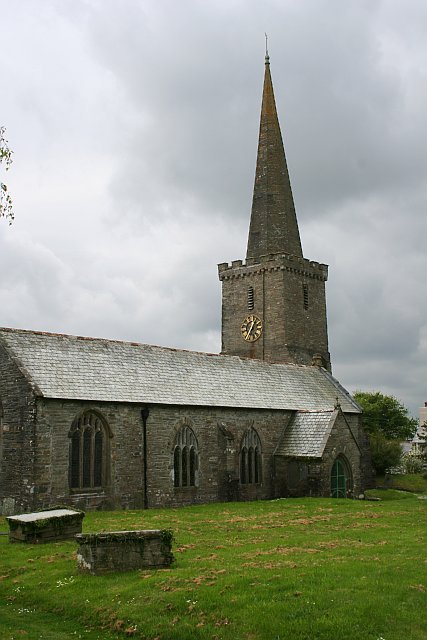
Menheniot parish church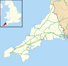
 Menheniot
Menheniot shown within CornwallPopulation 1,605 (Civil Parish, 2001) OS grid reference SX289628 Parish Menheniot Unitary authority Cornwall Ceremonial county Cornwall Region South West Country England Sovereign state United Kingdom Post town LISKEARD Postcode district PL14 Dialling code 01579 Police Devon and Cornwall Fire Cornwall Ambulance South Western EU Parliament South West England UK Parliament South East Cornwall List of places: UK • England • Cornwall 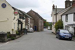 Menheniot village
Menheniot (Cornish: Mahunyes) is a civil parish and village in Cornwall, United Kingdom. The village is situated 2½ miles (4 km) southeast of Liskeard.[1] The meaning of the name is "sanctuary of Neot" (from minihi and Neot).[2]
Menheniot had a population of 1,605 in the 2001 census.[3] The village has a primary school, a pub, a shop and a post office.
Contents
Geography
To the south of the civil parish is Clicker Tor Quarry, a Site of Special Scientific Interest noted for its geological interest, containing one of the best examples of ultramafic rocks in the in South West England.[4]
At Coldrennick is a black and white mansion dated 1870 by the architect C. F. Hayward.[5]
Parish church
The parish church, located in the village, is dedicated to St Lalluwy. It has a buttressed tower and a spire.[6][7] The alleged dedications to St Antoninus and St Corentin derive from errors made by John Whitaker and Dr George Oliver. The church is a fine building of the 14th century but has been rendered less interesting by unsympathetic restorations. Accounts of four guilds associated with the church have been preserved: they relate to part of the reigns of Queen Mary I and Queen Elizabeth I. The date of the parish feast was altered in 1405 from March 8 to October 6. In 1478 the benefice was appropriated to Exeter College, Oxford and the cure of souls became a vicarage. Five chapels in the parish are recorded in the Middle Ages but they were abolished at the Reformation. There was also a lazar house at Maudlin near Liskeard which did remain in existence for some time after. As a valuable benefice several of the incumbents have been men of some distinction, including William Wykeham in 1365, Peter Courtenay, afterwards Bishop of Exeter, in 1477, and John Moreman, DD, 1529-54.[8] Dr Moreman was the author of a commentary on the epistle to the Romans and also the first to teach his people the Lord's prayer, creed and ten commandments in English.[9] George Hall became vicar of Menheniot and in 1641 archdeacon of Cornwall.[10][11] He was deprived of his offices under the Commonwealth but became a bishop after the Restoration.
Features of interest include the ceiled wagon roofs, the pulpit (1891 by Hems of Exeter), which depicts the polar exploits of Vice-Admiral Trelawny-Jago, and the earliest monumental brass in Cornwall (commemorating Sir Ralph Carmynow, d. 1386). There are a number of interesting monuments to the Trelawnys, including Jonathan Trelawny (d. 1674) and Edward Trelawny, Dean of Exeter (d. 1726). The black marble slab to L. Stephens (d. 1724) and the tablet to Lady Charlotte Carr (by M. Eames of Exeter) are also of interest.[12]
Captain John Richards Lapenotière who lived in the parish until his death in 1834 is buried in the churchyard.
Economy and transport
Menheniot lies in a former mining area and is surrounded by disused shafts and engine houses. Lead seams were discovered in the 1840s and Menheniot became the centre of a mining boom which lasted until the 1870s. During this period the population doubled.[6]
The village has a station, Menheniot railway station, on the Cornish Main Line which is operated by First Great Western.[13][14]
References
- ^ Ordnance Survey: Landranger map sheet 201 Plymouth & Launceston ISBN 9780319231463
- ^ Cornish Church Guide (1925) Truro: Blackford; p. 157
- ^ Office for National Statistics : Census 2001 : Parish Headcounts : Caradon Retrieved January 2010
- ^ "Clicker Tor Quarry". Natural England. 1986. http://www.sssi.naturalengland.org.uk/citation/citation_photo/1002982.pdf. Retrieved 26 October 2011.
- ^ Pevsner, N. (1970) Cornwall; 2nd ed. Harmondsworth: Penguin; p. 54
- ^ a b GENUKI; Menheniot; retrieved April 2010
- ^ CofE churches website; retrieved April 2010
- ^ Cornish Church Guide (1925) Truro: Blackford; p. 157-58
- ^ Brown, H. Miles (1964) The Church in Cornwall. Truro: Blackford; p. 40
- ^ http://www.british-history.ac.uk/report.aspx?compid=63712
- ^ Concise Dictionary of National Biography
- ^ Pevsner, N. (1970) Cornwall; 2nd ed., revised by Enid Radcliffe. Penguin; p. 117
- ^ National Rail website; Menheniot; retrieved April 2010
- ^ British Railway Stations website; retrieved April 2010
External links
 Media related to Menheniot at Wikimedia Commons
Geography of Cornwall Unitary authorities Major settlements Bodmin • Bude • Callington • Camborne • Camelford • Falmouth • Fowey • Hayle • Helston • Launceston • Liskeard • Looe • Lostwithiel • Marazion • Newlyn • Newquay • Padstow • Par • Penryn • Penzance • Porthleven • Redruth • Saltash • St Austell • St Blazey • St Columb Major • St Ives • St Just-in-Penwith • St Mawes • Stratton • Torpoint • Truro • Wadebridge
See also: Civil parishes in CornwallRivers Topics History • Status debate • Flag • Culture • Places • People • The Duchy • Diocese • Politics • Hundreds/shires • Places of interest • full list...Civil parishes of South East Cornwall constituency  Antony • Boconnoc • Botusfleming • Broadoak • Callington • Calstock • Deviock • Dobwalls and Trewidland • Duloe • Landrake with St Erney • Lanreath • Lansallos • Landulph • Lanlivery • Lanteglos • Linkinhorne • Liskeard • Looe • Lostwithiel • Luxulyan • Maker-with-Rame • Menheniot • Millbrook • Morval • Pelynt • Pillaton • Quethiock • Saltash • Sheviock • South Hill • St Cleer • St Dominick • St Germans • St Ive • St John • St Keyne • St Martin-by-Looe • St Mellion • St Neot • St Pinnock • St Veep • St Winnow • Torpoint • WarlegganCategories:
- Villages in Cornwall
- Civil parishes in Cornwall
- Sites of Special Scientific Interest in Cornwall


Wikimedia Foundation. 2010.