- River Truro
-
Coordinates: 50°15′25″N 5°02′42″W / 50.257°N 5.045°W
 The River Kenwyn, which converges with the Allen and becomes the River Truro
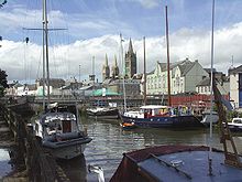
 The River Truro with a riverboat
The River Truro is a river in the city of Truro in Cornwall, England, UK[1]. It is the product of the convergence of the two rivers named Kenwyn and Allen which run under the city: the River Truro (named after the city) flows into the River Fal, estuarial waters where wildlife is abundant, and then out into the Carrick Roads. The river is navigable up to Truro.
The river valleys form a bowl surrounding the city on the north, east and west and open to the Truro River in the south. The fairly steep-sided bowl in which Truro is located, along with high precipitation swelling the rivers and a spring tide in the River Fal, were major causes of flooding in 1988 which caused large amounts of damage to the city centre.[2] Since then, flood defences have been constructed around the city,[2] including an emergency dam at New Mill on the River Kenwyn and a tidal barrier on the Truro River, to prevent future problems.
Malpas Estuary
The river from the city to the village of Malpas, including Lambe Creek and Calenick Creek, form Malpas Estuary SSSI (Site of Special Scientific Interest). It is an important habitat of tidal mudflats, which are feeding grounds for wildfowl and wading birds. The banks of the estuary are also noted for its flora.[3]
References
- ^ Ordnance Survey: Landranger map sheet 204 Truro & Falmouth ISBN 9780319231494
- ^ a b "Roads closed in torrential rain". BBC News Online. 24 November 2006. http://news.bbc.co.uk/1/hi/england/cornwall/6180748.stm. Retrieved 3 November 2011.
- ^ "Malpas Estuary". Natural England. 1992. http://www.sssi.naturalengland.org.uk/citation/citation_photo/1004029.pdf. Retrieved 3 November 2011.
Geography of Cornwall Unitary authorities Major settlements Bodmin • Bude • Callington • Camborne • Camelford • Falmouth • Fowey • Hayle • Helston • Launceston • Liskeard • Looe • Lostwithiel • Marazion • Newlyn • Newquay • Padstow • Par • Penryn • Penzance • Porthleven • Redruth • Saltash • St Austell • St Blazey • St Columb Major • St Ives • St Just-in-Penwith • St Mawes • Stratton • Torpoint • Truro • Wadebridge
See also: Civil parishes in CornwallRivers Topics History • Status debate • Flag • Culture • Places • People • The Duchy • Diocese • Politics • Hundreds/shires • Places of interest • full list...Categories:- Rivers of Cornwall
- Truro
- Sites of Special Scientific Interest in Cornwall


Wikimedia Foundation. 2010.