- Truro and Newquay Railway
-
Route diagram Legend
miles 
Cornish Main Line 
0.00 Truro 
Cornish Main Line 
5.25 Chacewater 

5.50 Blackwater Junction 

6.75 Mount Hawke 
8.50 St Agnes 9.50 Goonbell 
Goonbell Viaduct 10.75 Mithian 13.00 Perranporth Beach 13.25 Perranporth 15.75 Goonhavern Cox Viaduct 

14.50 Treamble 

Gravel Hill 
Deer Park 17.75 Shepherds 

19.00 Mitchell & Newlyn East Wheal Rose Mine 20.75 Trewerry & Trerice 

22.50 Trevemper 

Tolcarn Junction 
Trenance Viaduct 
23.75 Newquay 
Newquay Harbour The Truro and Newquay Railway was a Great Western Railway (GWR) line in Cornwall, United Kingdom designed to keep the rival London and South Western Railway (LSWR) out of the west of the county.[1]. The line was completed in 1905 and closed in 1963.
Contents
History
The railway route from London to Falmouth had been disputed between the GWR and LSWR since the 1840s. The Cornwall Railway, supported by the GWR, reached Falmouth in 1863 and the LSWR had a through route as far as Wadebridge in 1895. In order to hinder further expansion into its territory, the GWR obtained an Act of Parliament for the Truro and Newquay Railway on 3 June 1897.
Only 12½ miles of new railway were needed, despite the distance from Truro to Newquay being nearly 24 miles. Trains left Truro on the Cornish Main Line as far as Chacewater railway station and Blackwater Junction, where the new line turned northwards to reach the coast near St Agnes. It then turned north-eastwards to Perranporth and then turned inland to reach, to Shepherds on the former Cornwall Minerals Railway Newquay to Treamble branch.
The section from Blackwater to Perranporth opened on 6 July 1903, and from there to Shepherds was completed on 2 January 1905.[2] There was initially stations at only St Agnes, Perranporth, and Shepherds, but a six small halts were opened on 14 August 1905.
The line was single between Blackwater and Tolcarn junctions with passing loops; it had a 40mph (64 km/h) speed limit. There were 6 trains each way in 1910, rising to 12 by the summer of 1938. There was also a through train to London Paddington station in later years.[3]
The line closed on 4 February 1963.
Stations
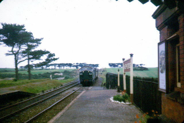
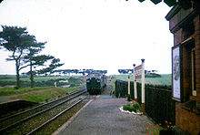 A Class 22 diesel approaching Shepherds station
Truro
Main article: Truro railway stationTruro station had opened on 4 May 1859 as the junction between the Cornwall and West Cornwall railways. It was rebuilt shortly before the start of the service to Perranporth.
Chacewater
Main article: Chacewater railway stationChacewater station had opened on 11 March 1852 with the West Cornwall Railway from Truro to Penzance. A loop line was added behind the platform used by trains towards Truro in 1912.
Blackwater Junction, ¼ mile west of the station, was originally triangular. The Truro to Newquay trains ran from East to North and a summer service ran from Newquay towards Redruth until 1916 using the North to West curve. This was retained for goods traffic until 5 May 1919. On 9 November 1924 the junction was closed and the line extended the short distance to Chacewater station on a new third track laid along the north side of the existing line. The loop platform then served branch trains in both directions.[4]
Mount Hawke
Serving Mount Hawke, the first halt along the line opened on 14 August 1905. It was a single platform in a cutting on the right hand side of trains going towards Newquay.[5]. The cutting containing the station site was filled in at the beginning of the 1990s and filled are now the approach road to the St. Agnes Traction Engine Rally site.
St Agnes
The station serving St Agnes opened with the line on 6 July 1903 and was one of the larger stations on the line.
The original station was on the left of trains towards Newquay and a small goods yard was situated behind the platform. A new passing loop was opened on 4 July 1937 and this entailed building a new, longer, platform between the two lines.[5] The station building at St. Agnes survives and is one of the few remaining substantial relics on this line.
Goonbell
This small halt was opened on 14 August 1905 to serve Goonbell, just outside St Agnes. Its single platform was in a shallow cutting on the left side of trains towards Newquay.[5] Today the cutting has been filled in but the wrought iron entrance gates survive.
The 140 yard (128m), five arch Goonbell Viaduct is ¾ mile beyond the station towards Newquay, still intact and resplendent.
Mithian
A small halt to serve Mithian was opened on 14 August 1905. It was on the left of trains going towards Newquay.[4] The cutting, station and adjacent overbridge have been long filled in and the station site is now barely traceable.
Perranporth Beach
A second station was opened in Perranporth on 20 July 1931, the last station added to the line. It had a single platform on the right of trains heading towards Newquay.[4] In a strange way, Perranporth Beach Halt is today the only station along the line to be still be open to catch trains – the sectional concrete platform was removed wholesale to see service on the Maritime Line as The Dell, subsequently renamed Falmouth Town railway station.
Perranporth
The station at Perranporth was the terminus of the line from 6 July 1903 until it was completed to Newquay on 2 January 1905 and was the only passing place between Chacewater and Shepherds until St Agnes station was rebuilt in 1937. The platform was situated between the two running lines. A small goods yard with a goods shed was situated on the south (right) side of the line.[3] ¾ miles beyond the station towards Newquay is the 89 yard (81m) Cox or Cocks Viaduct,still intact.
Goonhavern
A small halt was opened near Goonhavern on 14 August 1905. It was on the right of trains travelling towards Newquay.[4]
Shepherds
For the station in Kent, see Shepherds Well railway station.A branch to Treamble and the iron mine at Gravel Hill had been opened by the Cornwall Minerals Railway on 1 June 1874.[2] The section from Treamble to Gravel Hill closed in 1888 as the mine had been exhausted.
When the line was opened to Perranporth on 2 January 1905 a passing loop was installed at Shepherds with a platform on either side just west of where the line joined the Treamble branch. There was a small goods yard opposite the junction and a camping coach was kept here for the use of tourists arriving by train.[3]
The Treamble line closed in 1917 but was reopened in 1925. It was officially closed on 1 January 1952. There had been no traffic over it since 8 August 1949 and the track was not removed until 1956.
Mitchell and Newlyn
A small halt serving the villages of Mitchell and Newlyn East opened on 14 August 1905. It had a single wooden platform on the left of trains going to Newquay, but this was later replaced by a concrete platform.[5] This concrete platform and waiting shelter still survive in remarkably good order, amongst the undergrowth just across the road from the terminus of the Lappa Valley Railway.
The 15in (380mm) gauge Lappa Valley Railway now runs on the trackbed near here.
Trewerry and Trerice
The Newquay Railway, a horse-drawn tramway owned by Joseph Treffry, had opened a branch line from Newquay through Trewerry to the lead mine at East Wheal Rose near East Newlyn on 26 February 1849. This was converted as a locomotive-worked line and extended to Treamble by the Cornwall Minerals Railway on 1 June 1874.[2] A small halt serving the area around Trewerry and Trerice was opened on 14 August 1905. It had a single platform on the right of trains heading towards Newquay and was situated just west of the level crossing, east of which a siding was provided until 5 September 1948. The platform was built from wood but was later replaced by a concrete structure.[3]
Another siding was provided at Trevemper, which was on a short section of the old tramway route that was otherwise abandoned when the Cornwall Minerals Railway rebuilt the line on a new, straighter alignment in 1874. The short section from there to Tolcarn Junction at Newquay was retained after the remainder of the line was closed on 4 February 1963, but only lasted until 28 October 1963.
Newquay
Main article: Newquay railway stationThe Newquay Railway was opened in 1846 and a passenger service provided to Fowey from 20 June 1876. The station was rebuilt with three platforms to accommodate the opening of the Truro and Newquay line in 1905 but has been reduced to just a single track since its closure. It continues to serve trains on the Atlantic Coast Line from Par and continues to see a number of long distance services on summer weekends.
References
- ^ MacDermot, E T (1931). History of the Great Western Railway, volume II 1863-1921. London: Great Western Railway.
- ^ a b c Clinker, CR (1963). The Railways of Cornwall 1809 - 1963. Dawlish: David and Charles.
- ^ a b c d Vaughan, John (1991). The Newquay Branch and its Branches. Sparkford: Haynes/Oxford Publishing Company. ISBN 0-86093-470-5.
- ^ a b c d Cooke, R A (1977). Track Layout Diagrams of the GWR and BR WR: Section 10, West Cornwall. Harwell: R A Cooke.
- ^ a b c d Bennett, Alan (1988). The Great Western Railway in Mid Cornwall. Southampton: Kingfisher Railway Publications. ISBN 0-94618-453-4.
Categories:- Rail transport in Cornwall
- Railway lines constructed by the Great Western Railway
- Railway lines opened in 1905
- Closed railway lines in South West England
- Standard gauge railways in England
Wikimedia Foundation. 2010.