- Disused railway stations (Plymouth to Penzance Line)
-
There are seventeen disused railway stations between Plymouth in Devon and Penzance in Cornwall, United Kingdom. The remains of nine of these can be seen from passing trains. While a number of these were closed following the so-called "Beeching Axe" in the 1960s, many of them had been closed much earlier, the traffic for which they had been built failing to materialize.
Contents
Background
The railway from Plymouth to Truro was opened by the Cornwall Railway on 4 May 1859, where it joined up with the West Cornwall Railway which had been completed from there to Penzance on 16 April 1855. The section from Carn Brea to Angarrack dates back to the Hayle Railway, opened on 23 December 1837. It now forms Network Rail's Cornish Main Line.
Plymouth to Truro
Plymouth Millbay
Main article: Plymouth Millbay railway stationThe trains of the South Devon Railway finally reached the town of Plymouth on 2 April 1849. Docks were opened adjacent to the station and a new headquarters office was built next door. The station was expanded ready for the opening of the Cornwall Railway on 4 May 1859 and the South Devon and Tavistock Railway on 22 June 1859. It became known as Plymouth Millbay after other stations were opened in the town in 1876-7 at Mutley and North Road.
The station was closed to passengers on 23 April 1941 after bombs destroyed the nearby goods depot; the passenger station being used thereafter only for goods traffic and access to the carriage sheds. All traffic ceased from 14 December 1969 except for goods trains running through to the docks which continued until 30 June 1971.
The site is now occupied by the Plymouth Pavilions leisure complex. Two granite gate posts outside the Millbay Road entrance are all that is left of the station, although a goods shed on what used to be Washington Place is still extant nearby
Wingfield Villas Halt
This suburban halt near Devonport Junction in Plymouth was opened by the Great Western Railway on 1 June 1904. It was served by the Plympton to Saltash railmotor service introduced at that time to compete with the electric tramways in the town. It was closed in June 1921.
Ford Platform
Ford was one of the halts opened by the Great Western Railway for its railmotor services on 1 June 1904. It was located to serve the northern district of Devonport which had grown around the naval dockyard; other stations serving this traffic were opened at Keyham (1900) and Dockyard Halt (1905). The denuded remains of the southbound platform still remain, just west of an underbridge into the Royal Navy Dockyard and at the commencement of the cutting before Keyham.
It was closed on 6 November 1941, during the World War II blitz of Plymouth and Devonport.
Defiance Platform
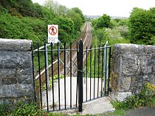 Old entrance to Defiance Platform
Defiance Platform was opened by the Great Western Railway on 1 March 1905 and served naval personnel travelling to the nearby torpedo training school on HMS Defiance which was moored nearby. Most trains were the railmotors and auto trains from Plympton which were run for an extra ¾ mile (1 km) beyond Saltash where they otherwise terminated. Access to the platform was by steps from a bridge that carried a road across the railway to Wearde Quay.
The line was doubled and moved on 4 February 1906 and Wearde became the junction for a deviation line to St Germans that allowed the removal of the remaining timber viaducts on the Cornish Main Line.
The station closed on 27 October 1930 but the platforms are still in existence and alterations to the road bridge to accommodate the new alignment of 1906 can be clearly seen. The old line was retained as carriage sidings for Saltash until 2 December 1964 and another siding behind the platform was kept in use until 1972.
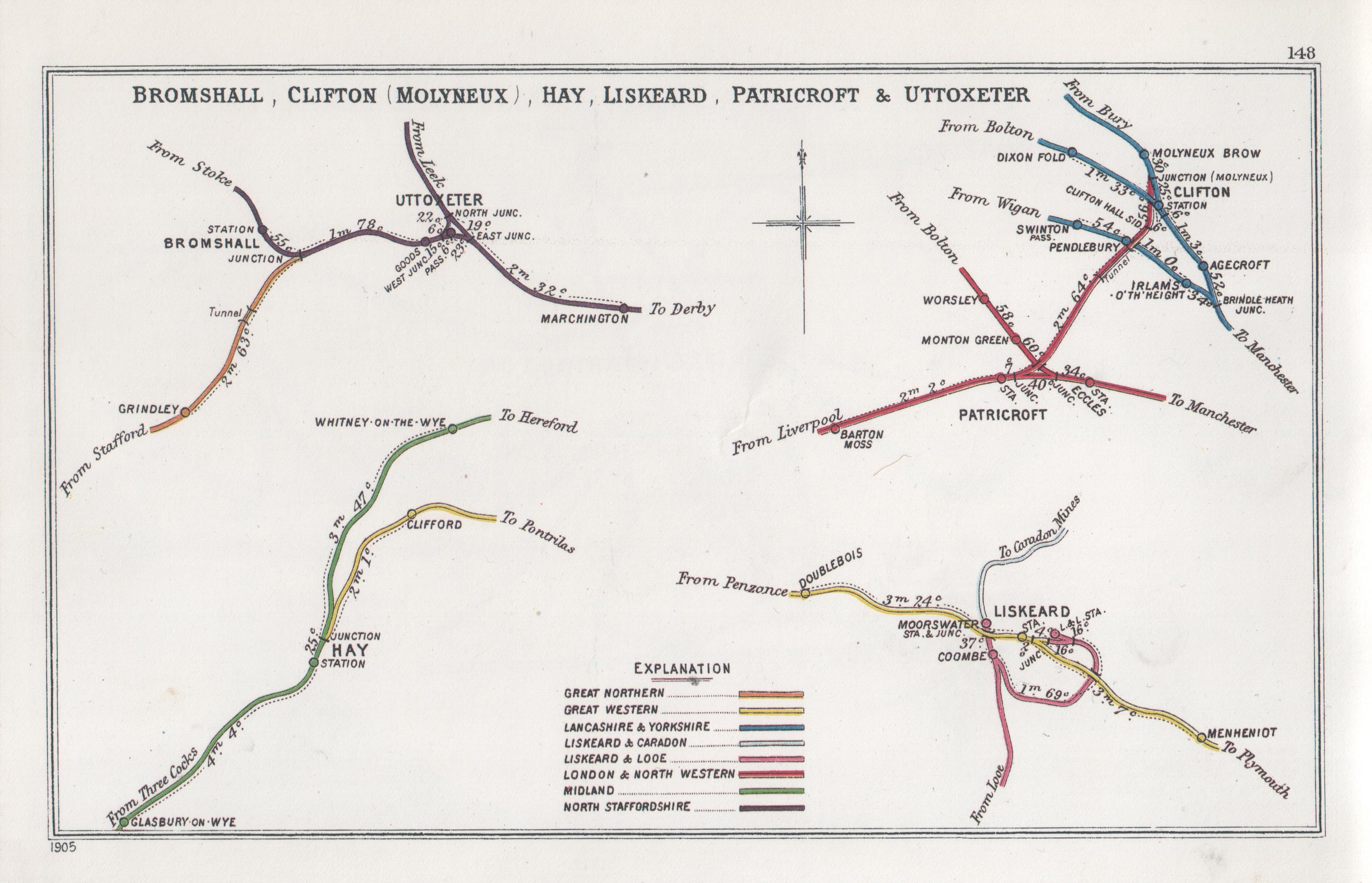
Doublebois
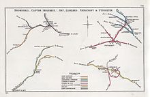 A 1905 Railway Clearing House Junction Diagram showing (lower right) railways in the vicinity of Doublebois
Doublebois was at the summit of the Cornwall Railway. A siding was provided here when it opened on 4 May 1859 to enable trains to be split into smaller parts to enable them to be worked over the steep inclines up from Liskeard and Bodmin Road.
In January 1860 the railway company was asked to provide a facility here for goods traffic, which they acceded to after local people subscribed £130 towards it and offered the necessary land. Because of this the company offered to build an accompanying passenger station. The station opened on 1 June 1860, providing a service to people and mines in the St Neot area.
The station has since been closed (5 October 1964) but the earthworks can still be seen.
Respryn
Due to delays in securing the site for Bodmin Road, the Cornwall Railway provided a temporary station a little further west for the opening of the line on 4 May 1859 until the permanent station was ready on 27 June 1859.
Burngullow
50°20′13″N 4°50′06″W / 50.337°N 4.835°W
Once it was open, the Cornwall Railway found there was a demand for facilities to transport china clay from the St Stephens district to Par harbour. To satisfy this they opened a station at Burngullow on 1 February 1863. The construction costs were largely met by Mr Robartes, who had interests in the extraction of the china clay.
A branch line to Nanpean was opened for goods traffic by the Newquay and Cornwall Junction Railway on 1 July 1869. A small engine shed was built by them on the north side of the station, this closed in 1922.
The station was closed and rebuilt a little further west on 1 August 1901, but closed to passengers on 14 September 1931. The sidings and branch continue to handle heavy china clay traffic.
The large dryer and storage sheds alongside the main line are the Blackpool clay works; Burngullow clay works are smaller and situated alongside the branch line a short distance from the junction.
Two railway accidents have happened here, both involving runaway china clay trains. On the first occasion a train had left Burngullow with wagons for Par harbour on 29 October 1872. It was unable to stop for signals at St Austell but the driver of the passenger train coming in the other direction saw the train sliding towards it and reversed his train back to Par.
On 9 June 1952 a similar problem occurred with a train on the branch line approaching Burngullow. This time the train ran into a siding where it collided with a stationary engine. Unfortunately the driver of the runaway train, who had stayed at the controls in an attempt to bring it to a halt, later died from his injuries.
The former 'up side' (London bound) station building still remains some seventy years plus after closure.
The signal box was closed in 1986 when the Burngullow to Probus section of the Mainline was singled, and the signals were then controlled by the Signal Box at Par railway station. The double line was re-instated in 2004.
Grampound Road
 New houses have been built at Grampound Road since the station closed.
A station to serve Grampound was opened with the Cornwall Railway on 4 May 1859, but it was known as "Grampound Road" due to the distance from that town. A newspaper at the time reported at the time merely that "it comprises arrival and departure stations exactly similar to those at Par."
A goods shed was not provided until 1864 but the goods traffic developed quickly: 3,580 cattle were dispatched in the twelve months to June 1869, more than any other station on the line.
Because of its remote location two cottages were built in 1860 for the station master and his staff. A small village known as Grampound Road grew up around the railway station and continues to expand despite the station closing (along with Doublebois, Chacewater, Scorrier, Gwinear Road and Marazion) on 5 October 1964. Harry Hingston was the last registered paid employee and station master.
The site is easily recognised from passing trains.
Probus and Ladock Halt
This halt was opened by the Great Western Railway on 1 February 1908. Unusually for a stop classified as a halt, it was staffed, at least initially. Characteristic Great Western Railway corrugated iron waiting shelters were provided on both of the wooden platforms. The Great Western Railway was nationalised into British Railways from 1 January 1948 and the station was closed on 2 December 1957.
The station was nearer to Probus than Ladock, indeed Grampound Road railway station was also convenient for the latter village.
Both platforms still remain here and although grassed over are easily detectable. If you follow the B3275 towards Probus,then turn off left towards Ladock there is a rail bridge over the road. Just under the bridge on the right is the former pathway up to the up side platform of the halt, which now houses a mobile phone mast.
Truro to Penzance
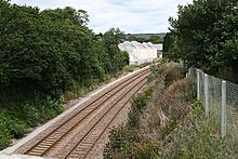
Chacewater
 Chacewater railway station in 2008
A station was opened at Chacewater by the West Cornwall Railway on 25 August 1852. On 6 July 1903 a branch line to Perranporth was opened from nearby Blackwater; it was extended to Newquay on 2 January 1905. Blackwater Junction was closed on 9 November 1924 which resulted in the physical junction being moved the half mile to Chacewater station, although most trains ran through to Truro.
The Perranporth line closed on 4 February 1963. Even after its closure to passengers a few years later, Chacewater station was retained for goods traffic for many years, latterly for Blue Circle Cement. The Penzance bound platforms can still be seen, complete with much altered station building.
There are two viaducts east of Chacewater. The 128 yard (181 m) Blackwater Viaduct is immediately east of the station site and the 93 yard (132 m) Chacewater Viaduct is a little further east towards Truro.[1] .[2]
Preceding station Historical railways Following station Truro Great Western Railway
Cornish Main LineRedruth Great Western Railway
Truro & NewquayMount Hawke Halt Scorrier
A station was opened at Scorrier by the West Cornwall Railway on 25 August 1852. Initially known as "Scorrier Gate", the name was changed to "Scorrier" in March 1856. It reverted to "Scorrier Gate" from 1 June 1859 but became plain "Scorrier" once more on 1 October 1896. It closed to passengers on 5 October 1964.
Preceding station Disused railways Following station Redruth Great Western Railway
Cornish Main LineChacewater Carn Brea
A station was opened near Carn Brea on 23 May 1843 by the Hayle Railway and named "Pool" after a nearby village. The railway was closed on 16 February 1852 and reopened by the West Cornwall Railway on 11 March 1852, however Pool station remained closed until 25 August 1852 when it was reopened as "Carn Brea", only to be renamed "Pool" once more in June 1854. It reverted to "Carn Brea" on 1 November 1875. It was closed on 2 January 1961.
Carn Brea was the home of the West Cornwall Railway's workshops where they maintained the locomotives and rolling stock.
Preceding station Disused railways Following station Camborne Great Western Railway
Cornish Main LineRedruth Dolcoath Halt
The Great Western Railway opened a railmotor halt near Dolcoath mine on 28 August 1905 but it closed again on 1 May 1908; the days when Dolcoath was one of the biggest mines in Cornwall were long past. It was situated to the west of Dolcoath level crossing and the site can be recognised because of this.
Penponds
The Hayle Railway provided a station at Penponds from 23 May 1843 until 16 February 1852. It was not replaced when the West Cornwall Railway opened a month later.
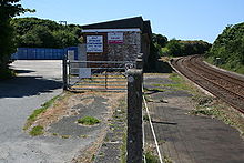
Gwinear Road
A station known as "Gwinear Road" was opened by the West Cornwall Railway on 11 March 1852 west of a level crossing and became a junction for the Helston Railway on 9 May 1887. The goods yard lay west of the station to the north of the line, but extensive sidings were constructed alongside the main line east of the level crossing to handle traffic for the branch.
The station formerly had two signalboxes: West, on the down platform itself, and East, out in the goods marshalling yard.
The branch line closed to passengers on 3 September 1962 and to goods on 8 October 1964; the and the station is now closed. The former 'down' Penzance-bound platform-cum- Helston branch bay is still more or less intact.
The DMU, formerly on site undergoing restoration by the Helston Railway Preservation Company in the cattle dock just east of the level crossing, has now been moved to the company's [Trevarno] base.
Preceding station Disused railways Following station Hayle Great Western Railway
Cornish Main LineCamborne Angarrack
The Hayle Railway introduced passenger trains on 23 May 1843. The service was closed on 16 February 1852. On 11 March 1852 the West Cornwall Railway opened a new station. The old station had been on the section of the Hayle Railway that was closed entirely as a steep rope-worked incline descended from Angarrack to sea level at Copperhouse, it was replaced by a much gentler incline to the new Hayle railway station. However the new Angarrack station was closed in 1853. (See also Angarrack viaduct.)
Copperhouse Halt
The Great Western Railway introduced railmotor services in west Cornwall and provided several small halts at which they called. Copperhouse was one of the small halts provided for these services, opening on 1 July 1905 to provide a service to the Copperhouse district in Hayle.
An earlier station had been provided at Copperhouse nearer the waterfront by the Hayle Railway from 23 May 1843 until their line closed on 16 February 1852.
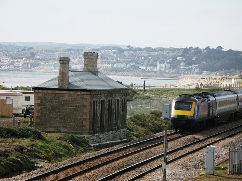
Marazion
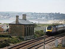 43189 passes the disused Marazion station in 2007
A station was opened at Marazion by the West Cornwall Railway on 11 March 1852. The original single platform was situated on the south side of the line but the station was rebuilt about thirty years later when a second platform was added. The line westwards to Penzance was doubled in 1893 and the goods yard expanded so that it could share in handling the large volume of perishable traffic – fish, fruit and vegetables – from the surrounding farms and harbours. The line eastwards to St Erth was not doubled until 1929.
The station is situated on the shore of Mount's Bay with fine views of St Michael's Mount and for many years was home to six old Pullman coaches that were formerly used as camping coaches. Three of these were rescued and restored, and now provide sleeping accommodation at Petworth railway station, which has been converted into a guest house. One was purchased privately while the others were left to become derelict until broken up on site.[3] In 2006 the remains of these coaches was cleared away from the site to make way for nine holiday cottages,the old station has now been fully restored into a two bedroom bungalow currently owned by the developers.[citation needed] The 1880s station building still stands, but part of the line westwards is currently reduced to a single track.
Preceding station Disused railways Following station Penzance Great Western Railway
Cornish Main LineSt Erth See also
Disused railway stations (Exeter to Plymouth Line)
References
- ^ Ordnance Survey: Landranger map sheet 204 Truro & Falmouth ISBN 9780319231494
- ^ Binding, John (1993). Brunel's Cornish Viaducts. Atlantic Transport Publishing. pp. 106/4. ISBN 0-90689-956-7.
- ^ Abandoned lines and railways – Marazion (includes pictures of station and coaches) Accessed 05 Jun 2007
Sources
- Bennett, Alan (1990). The Great Western Railway in East Cornwall. Cheltenham: Runpast Publishing. ISBN 1-87075-411-5.
- Bennett, Alan (1988). The Great Western Railway in Mid Cornwall. Southampton: Kingfisher Railway Publications. ISBN 0-94618-453-4.
- Bennett, Alan (1988). The Great Western Railway in West Cornwall. Cheltenham: Runpast Publishing. doi:1990. ISBN 1-87075-412-3.
- Clinker, CR (1963). The Railways of Cornwall 1809 - 1963. Dawlish: David and Charles.
- Cooke, R A (1977). Track Layout Diagrams of the GWR and BR WR, Section 10: West Cornwall. Harwell: R A Cooke.
- Cooke, R A (1977). Track Layout Diagrams of the GWR and BR WR, Section 11: East Cornwall. Harwell: RA Cooke.
- Cooke, R A (1979). Track Layout Diagrams of the GWR and BR WR, Section 12: Plymouth. Harwell: R A Cooke.
- MacDermot, E T (1931). History of the Great Western Railway, volume II 1863-1921. London: Great Western Railway.
- St John Thomas, David (1973). West Country Railway History. Newton Abbot: David and Charles. ISBN 0-71536-363-8.
- Pre-grouping Atlas and Gazetteer. Shepperton: Ian Allan Limited. 1976. ISBN 0-71100-320-3.
Categories:- Disused railway stations in Cornwall
- Disused railway stations in Devon
- Former Great Western Railway stations
- Rail transport in Cornwall
- Rail transport in Devon

Wikimedia Foundation. 2010.