- Disused railway stations (Bodmin to Wadebridge line)
-
Wadebridge to Wenfordbridge Legend

Towards Padstow 
0m 00ch Wadebridge 

0m 58ch North Cornwall line 
1m 20ch Pendavey Bridge (River Camel) 
1m 40ch Rifle Range Platform 


1888 diversion 
3m 09ch Grogley Junction 3m 11ch Grogley Halt 
4m 25ch Ruthernbridge 
4m 49ch Nanstallon crossing 4m 50ch Nanstallon Halt 4m 78ch Boscarne crossing 
Boscarne Junction (modern halt) 

5m 00ch Boscarne Junction 
5m 14ch Boscarne Exchange Platform 
River Camel 

5m 25ch Dunmere Junction 
5m 20ch Dunmere Halt 
6m 68ch Bodmin North 5m 70ch St Lawrence Platform (GWR) 

7m 48ch Bodmin General (GWR) 
Bodmin & Wenford Steam Railway 5m 20ch Dunmere crossing (A389) 
5m 44ch Dunmere wharf 6m 68ch Penharcard siding 8m 32ch Helland wharf 8m 40ch Hellandbridge crossing 10m 09ch Tresarret quarry siding 10m 20ch Stump Oak siding 10m 42ch Tresarret crossing 10m 46ch Tresarret wharf 11m 02ch Pooleys Bridge crossing 11m 30ch Wenford clay dries 11m 78ch Wenfordbridge 12m 58ch De Lank quarry There are eight disused railway stations between Wadebridge and Bodmin North on the former Bodmin and Wadebridge Railway in Cornwall, in the United Kingdom, with ten other closed sidings on the branches to Ruthern Bridge and Wenfordbridge. The section from Boscarne Junction to Bodmin General is currently part of the Bodmin and Wenford Steam Railway; the line from Wadebridge to Wenfordbridge is now part of the Camel Trail, and the line to Ruthern Bridge can be followed for much of its length as it runs parallel to a public road.
Contents
Background
The Bodmin and Wadebridge Railway (B&W) opened in 1834 to carry sand brought up the River Camel for use as a soil improver. Extensions were added to Wenfordbridge and Ruthern Bridge to handle freight traffic later that year, particularly stone from the De Lank quarry and Tin from the Mulberry mine. In 1847 the London and South Western Railway bought the B&W, and connections to the parent company came via the North Cornwall Line in 1895. Connection to the GWR at Bodmin Road was earlier, in 1888, and the line was finally extended to Padstow in 1899. For much of its life the line was famed for the Beattie Well Tanks, three small engines built in the 1870s and transported to Wadebridge by sea to work the lightly laid curves of the line to Wenfordbridge.
Wadebridge to Bodmin
Wadebridge
Main article: Wadebridge railway stationRifle Range platform
The platform was built around 1880 to serve a firing range with trains only stopping with written permission from the army. Periods of use centred around the Boer War and World War I. Troops were always sent by rail as there was no other means of access. Use of the range ceased after this although the platform, with its cinder surface, was maintained into the 1950s. Named Shooting Range Platform and used until after 1947.[1]
Grogley Halt
Grogley Halt opened on 2 July 1906 in association with the railmotor service between Bodmin North and Wadebridge although the wooden platform was unlit and trains only stopped during daylight. It is unclear whether any shelter was provided initially, but a GWR style pagoda shelter was provided before 1933, being replaced by a wooden shelter when the platform was rebuilt in concrete in the 1950s. The line just north of Grogley halt was realigned in 1888, the junction to Ruthern Bridge being on the old alignment which was disconnected at one end only. A ground frame controlled the new junction, which thus involved a reversal on the old alignment to gain the Ruthern Bridge line. The early method of accessing the platform across the River Camel is unclear as access was latterly via the bridge that carried the Ruthern Bridge line after that was lifted in 1934. The station closed to passengers on 30 January 1967.
Preceding station  Heritage railways
Following station Wadebridge Guineaport Bodmin and Wenford Railway
(Proposed RailTrail extension)Boscarne Junction Disused railways Wadebridge London and South Western Railway
Bodmin and Wadebridge RailwayBoscarne Junction Nanstallon Halt
Originally a single siding, or wharf, was provided here which at one time included a goods shed. The date of the level crossing and associated signal box is a matter of conjecture, but the rough track which crossed the railway at this location was improved by the LSWR for the opening of the Halt on 2 July 1906. The halt itself, as at Grogley, was of timber without any form of shelter. A GWR "pagoda" shelter was provided later which lasted into the 1960s. The siding was closed 2 May 1960 and the associated ground frame removed in April 1961. The station closed to passengers on 30 January 1967.
Boscarne Junction
main article Boscarne Junction
Boscarne Junction was created in 1888 when the GWR built a line to connect from their station in Bodmin to the Bodmin and Wadebridge Railway. Originally there was a loop on either side of the line, each straddling the junction which was controlled by a signal box; a second and longer loop was added from the signal box extending down the Wenfordbridge line well beyond the junction before 1911. The purpose of the GWR line was to take china clay from Wenford clay dries to the docks at Fowey, the traffic having previously been taken by the LSWR to Wadebridge. The line to Wadebridge was truncated at the road just beyond the signal box in 1981, and the line closed completely on 3 October 1983. Trains returned to Boscarne Junction in 1997 when the Bodmin and Wenford Steam Railway built a platform and began operating trains from Bodmin General. This new platform is on the site of Boscarne Exchange Platform see next paragraph.
Boscarne Exchange Platform
From 15 June 1964 the passenger service between Bodmin North and Wadebridge was truncated at Boscarne Junction, passengers from Bodmin North using a shuttle service operated by an AC railbus, also serving Dunmere Halt, to travel as far as Boscarne; onward travel was by using the Bodmin General to Padstow services. In order for passengers to change trains a station was built which must have been one of the smallest stations in England. On the line to Bodmin North it had a small patch of clear ground to allow the AC railbus to lower the ladder fitted below the passenger door, while there was one small platform capable of taking one coach on the line to Bodmin General, this being dominated by a huge sign stating "Boscarne Junction. Change for Dunmere and Bodmin North". There was no shelter, no public access, no tickets, and initially no lighting. The station, referred to in the timetable as Boscarne Exchange Platform, closed on 18 April 1966 when two trains daily from Bodmin General reversed at the junction, travelling to Dunmere halt and Bodmin North before returning and continuing on to Wadebridge.
Dunmere Halt
Dunmere Halt was opened, like the halts at Grogley and Nanstallon, on 2 July 1906 in association with the railmotor service between Bodmin North and Wadebridge. The original platform at Dunmere is a matter of conjecture, but in the 1960s it was of concrete with a GWR style pagoda shelter. The halt was situated in a shallow cutting, and access was by a short footpath sloping down from the A389 overbridge which was situated at one end of the platform. The station closed to passengers on 30 January 1967 when operation of the line from Dunmere Junction to Bodmin North ceased. The platform is still in situ today and has been carefully maintained. The trackbed is now a footpath.
Bodmin North
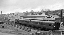 Bodmin North in 1964
When the Bodmin and Wadebridge Railway opened on 4 July 1834, trains could only get as far as a temporary terminus at Dunmere, the Station at Bodmin not being opened until 30 September 1834. From 1 November 1886 to 1 November 1895 the station was closed to allow for a realignment of the railway at Dunmere, replacing a level crossing with an overbridge, and complete renewal of the track. The new station had a single platform face containing the station building and a canopy. South of the platform road was a run-round and a third road giving access to a short siding and a cattle dock, and leaving the line in front of the signal box, a further siding served the goods shed, with a private siding for the gas works opposite. A 50-foot turntable had been provided before the rebuilding work, and remained connected although usage was low as most passenger trains where operated by tank engines. The station was renamed Bodmin North in 1949 to differentiate it from Bodmin General. Freight facilities were withdrawn on 24 July 1964 and the station closed on 30 January 1967. The station has been completely demolished and the site is now occupied by a supermarket.
Boscarne to Bodmin General
St Lawrence Platform
A platform, nominally provided for the hamlet of St Lawrence, was opened in 1906 on the GWR line from Bodmin to Boscarne Junction. It closed in 1917.
Bodmin General
Main article Bodmin General railway station.
The Great Western Railway opened a terminus in Bodmin on 27 May 1887, the line diverging from the Cornish Main Line at Bodmin Road. On 3 September 1888 a new line connected with the Bodmin and Wadebridge Railway at Dunmere Junction.
Passenger services ceased on 30 January 1967, freight services were withdrawn from Bodmin General on 1 May 1967 and the signal box closed later that year but the station was retained as a reversal point for freight trains from Wenford until 3 October 1983. It is now the principal station of the Bodmin and Wenford Steam Railway.
Grogley to Ruthern Bridge
Ruthern Bridge
The extension to Ruthern Bridge was opened on 30 September 1834, and served mines in the locality producing copper, iron and lead, and especially tin from Mulberry Mine. Provision for this traffic was made by two sidings, one of which ran over a series of sand drops; an additional loop capable of accommodating eight wagons was added 6 chains towards Grogley in 1914. A siding near to Grogley junction was provided at an early date to serve an ochre pit although this was removed soon after the pit ceased working in 1912. There was never any passenger service, Ruthern Bridge being little more than a small collection of cottages and farms. The line, which climbed steadily at 1 in 158 for most of its length, closed on 29 November 1933 with the track being lifted the following year.
Boscarne Junction to Wenfordbridge
Minor sidings
Dunmere
The single trailing siding at Dunmere, which was situated on the left of the line immediately after crossing the A389, was a public siding (as opposed to a private siding), and for much of its life the main traffic was grain for Hawke's mill. Originally termed "borough bounds wharf" for being just outside the Bodmin boundary, the siding closed on 14 May 1969 and was removed in November that year.
Penharcard
A single facing siding was provided at Penharcard, although it was closed and removed prior to 1925.
Helland A single facing siding was provided on the side of the line nearest the River Camel at Helland Wharf. Pictures show the buildings, as at other places on the B&W, extremely close to the line. The siding closed on 2 May 1960.
Tresarret Quarry
A single facing siding was provided for Tresarret quarry from around 1920. It closed in the mid 1930s.
Stump Oak siding
A loop 7 chains in length was provided at Stump Oak, or Parkyns, around 1880 although this had been removed by 1923.
Tresarret Wharf At Tresarret there was a loop on the north side of the line some 6 chains in length, this was closed in July 1970 and removed the following year. A shorter siding on the other side of the line was removed on 18 January 1932.
Wenford clay dries
English China Clays Lovering Pochin had six clay dries at Wenford served by a pipe delivering clay slurry from Stannon Moor over four miles distant. Initially there was a loop serving dries 1 and 2, with a line extending back then diverging to give access to dries 3 to 6 which were set back further from the main running line. The first part of the loop and associated access was removed around 1920. Traffic to the dries was coal (inward) and china clay; high quality bagged clay in vans and lower quality in sheeted open wagons called clay hoods. After the closure of Wenfordbridge in 1971 the line ended just beyond the clay dries, 11 miles and 71 chains from Wadebridge. The line closed completely on 3 October 1983.
Wenfordbridge
The hamlet of Wenfordbridge was the furthest outpost of the LSWR from London Waterloo. It opened on 30 September 1834 as part of the Bodmin and Wadebridge Railway and changed very little until closure in 1971. There were three sidings for loading and unloading goods, predominantly coal inwards and stone out from local quarries, basic manpower being supplemented in Southern Railway days by a five ton capacity gantry crane spanning two of the sidings. A fourth siding continued on to the De Lank quarries.
De Lank Quarry
At the end of one of the sidings at Wenfordbridge the line continued, curving sharply off to the right and crossing the public road without barrier or sign before continuing via a rope-worked incline of 1 in 8 over a hill and down to the De Lank Quarries of T W Ward & Sons ½ mile distant. The incline itself was of three rails; the inner or centre rail being common to wagons both ascending and descending the incline. There was no engine working the incline which worked on the balance principle; horsepower was used for shunting until introduction of a simplex shunter in the 1920s. The line was opened in the 1890s and closed around 1940 although the rails across the road remained until 1967.
Bibliography
- Cooke, R. A. (1977). Track Layout Diagrams of the GWR and BR WR, Section 10: West Cornwall. Harwell: R. A. Cooke.
- Cooke, R. A. (1977). Track Layout Diagrams of the GWR and BR WR, Section 11: East Cornwall. Harwell: R. A. Cooke.
- Croughton, Godfrey; Kidner, R.W.; Young, Alan (1982). Private and Untimetabled Railway Stations. Trowbridge: Oakwood Press. ISBN 0 85361 281 1.
- Fairclough, Tony; Alan Wills (1979). Southern Branch Line Special No. 1; Bodmin and Wadebridge 1834-1978. Truro: D. Bradford Barton. ISBN 0-85153-343-4.
- Hurst, Geoffrey (1983). Miles and Chains 4 - Western. Worksop: Milepost Publications. ISBN 0-95075-77-3.
- Mitchell, David (1994). British Railways Past and Present 17 - Cornwall. Peterborough: Past and Present Publishing Ltd. ISBN 1-85895-060-0.
- Mitchell, Vic; Keith Smith (1996). Branch Lines Around Bodmin. Midhurst: Middleton Press. ISBN 1-873463-83-9.
- Semmens, Peter (1988). Railway World Special: The Withered Arm - The Southern West of Exeter. Weybridge: Ian Allen. ISBN 0-7110-1806-5.
References
- ^ Croughton, Kidner & Young 1982, p. 125.
Categories:- Disused railway stations in Cornwall
- Rail transport in Cornwall

Wikimedia Foundation. 2010.