Diglis Basin

Diglis Basin
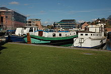
A view of Diglis Basin. The Worcester and Birmingham canal continues in the gap between buildings visible at the rear of the photo
[v · d · e]Worcester and Birmingham Canal
Legend
Urban straight track
BCN Main Line
Waterway with marina/wharf on left + Unknown BSicon "uGRENZE"
Gas Street Basin (Worcester Bar)
Unknown BSicon "uBROADo"
Holliday Street aqueduct
Unknown BSicon "uAKRZu"
86 A4540 Middle Ring Road
Unknown BSicon "uTUNNEL1"
Edgbaston Tunnel (105 yd)
Waterway under railway bridge
81 Cross-City Line
Unknown BSicon "ugSTRq" Waterway with unused unwatered canal T-junction to right
Dudley Canal Selly Oak Jn
Unknown BSicon "uAROADo"
Ariel Aqueduct
Unknown BSicon "uAKRZu"
80 A38 Bristol Road
Waterway under railway bridge
79 Cross-City Line
Unknown BSicon "uAKRZu"
75 A441 Pershore Road
Waterway under railway bridge
74 Camp Hill Line
Unknown BSicon "uJUNCld" Unknown BSicon "uHSTOPLOCK"
Stratford-upon-Avon Canal
Enter urban tunnel
-- Kings Norton Jn
Exit urban tunnel
Wasthill Tunnel (2726 yd)
Unknown BSicon "uAKRZu"
67 A441 road bridge
Unknown BSicon "uRESRl" Unknown BSicon "uFEEDERl"
Upper Bittell Resr and feeder
Unknown BSicon "uRESRl" Urban straight track
Lower Bittell Resr
Waterway under motorway
M42 road bridge
Unknown BSicon "uJUNCld" Waterway turning to right
Crown Meadow Arm
Unknown BSicon "uTUNNEL1"
Shortwood Tunnel (613 yd)
Unknown BSicon "uTUNNEL1"
Tardebigge Tunnel (580 yd)
Unknown BSicon "uxDOCKl" Waterway T-junction to right
Tardebigge Wharf
Unknown BSicon "uSTRpr" Unknown BSicon "uRESRr"
Tardebigge Resr / engine house
Unknown BSicon "uLOCKSu"
29-58 Tardebigge Locks (30)
Unknown BSicon "uLOCKSu"
23-28 Stoke Locks (6)
Unknown BSicon "uLOCKSu"
17-22 Astwood Locks (6)
Waterway under railway bridge
37 Railway bridge
Unknown BSicon "uFGATEr" Waterway T-junction to right
Droitwich Canal
Unknown BSicon "uTUNNEL1"
Dunhampstead Tunnel (230 yd)
Waterway under motorway
24A M5 road bridge
Unknown BSicon "uLOCKSu"
11-16 Offerton Locks (6)
Unknown BSicon "uAKRZu"
22A A449(T) bridge
Unknown BSicon "uLOCKSu"
5-10 Locks (6)
Unknown BSicon "uFGATEu"
4 Blockhouse Lock
Unknown BSicon "uFGATEu"
3 Sidbury Lock, Worcester
Unknown BSicon "uDRYr" Unknown BSicon "uJUNC" Unknown BSicon "uxDOCKr"
Diglis Basins and dry dock
Unknown BSicon "uLOCKSu"
1-2 wide beam locks (2)
Unknown BSicon "uJUNCe"
River Severn


Diglis Basin is a canal basin on the Worcester and Birmingham Canal. It is situated in the centre of Worcester, England, near The Commandery (a command post during the English Civil War.

To the north is Tibberton (8.41 miles and 14 locks away) and to the west is Diglis Junction (0.25 miles and 2 locks to the west)[1] where the canal meets the River Severn. It is the first basin (with associated amenities) reached after joining the canal from the River Severn.

Facilities available

With its central position in Worcester, Diglis Basin is very convenient for shops and leisure facilities in the centre of the city. It also has the following facilities of its own:

  • Water point
  • Rubbish disposal
  • Dry dock

References


Coordinates: 52°11′00″N 2°13′14″W / 52.1834°N 2.2206°W / 52.1834; -2.2206


Wikimedia Foundation. 2010.

Игры ⚽ Поможем написать курсовую

Look at other dictionaries:

  • Worcester and Birmingham Canal — The Worcester and Birmingham Canal is a canal linking Birmingham and Worcester in England. It starts in Worcester, as an offshoot of the River Severn (just after the river lock) and ends in Gas Street Basin in Birmingham. It is convert|29|mi|km… …   Wikipedia

  • Avon Ring — The Avon Ring is a canal ring which is located to the south west of Birmingham in England, and connects the major towns of Stratford upon Avon, Evesham, Tewkesbury, Worcester and the southern outskirts of Birmingham. It consists of stretches of… …   Wikipedia

  • Droitwich Canal — Droitwich Canals One of the Hanbury locks Original owner Sir George Duckett Principal engineer James Brindley Date …   Wikipedia

  • Cross Country Route — This page is about the line built by the Midland Railway. For other services see Cross Country services Cross Country Route A class 221 Super Voyager leaving Bristol Temple Meads station …   Wikipedia

  • Monarch's Way — Waymark on a Public Footpath Length 615 miles (990 km) Location Warwickshire, Worcestershire, Staffordshire, Sussex, Gloucesters …   Wikipedia

  • Oxford, Worcester and Wolverhampton Railway — [v · d · …   Wikipedia

  • A38 road — A38 road …   Wikipedia

  • Cotswold Way — passing through the site of the Battle of Lansdowne Length 102 mi (164 km) Location Central England Desi …   Wikipedia

  • Cotswold Line — Overview Type Rural, Heavy rail System National Rail …   Wikipedia

  • Cross-City Line — Butlers Lane station Overview Type Heavy rail, Suburban rail …   Wikipedia

Share the article and excerpts

Direct link
Do a right-click on the link above
and select “Copy Link”