- New River (Mexico
-
"Rio Nuevo" redirects here. For other uses, see Rio Nuevo (disambiguation).
New River
Rio Nuevo
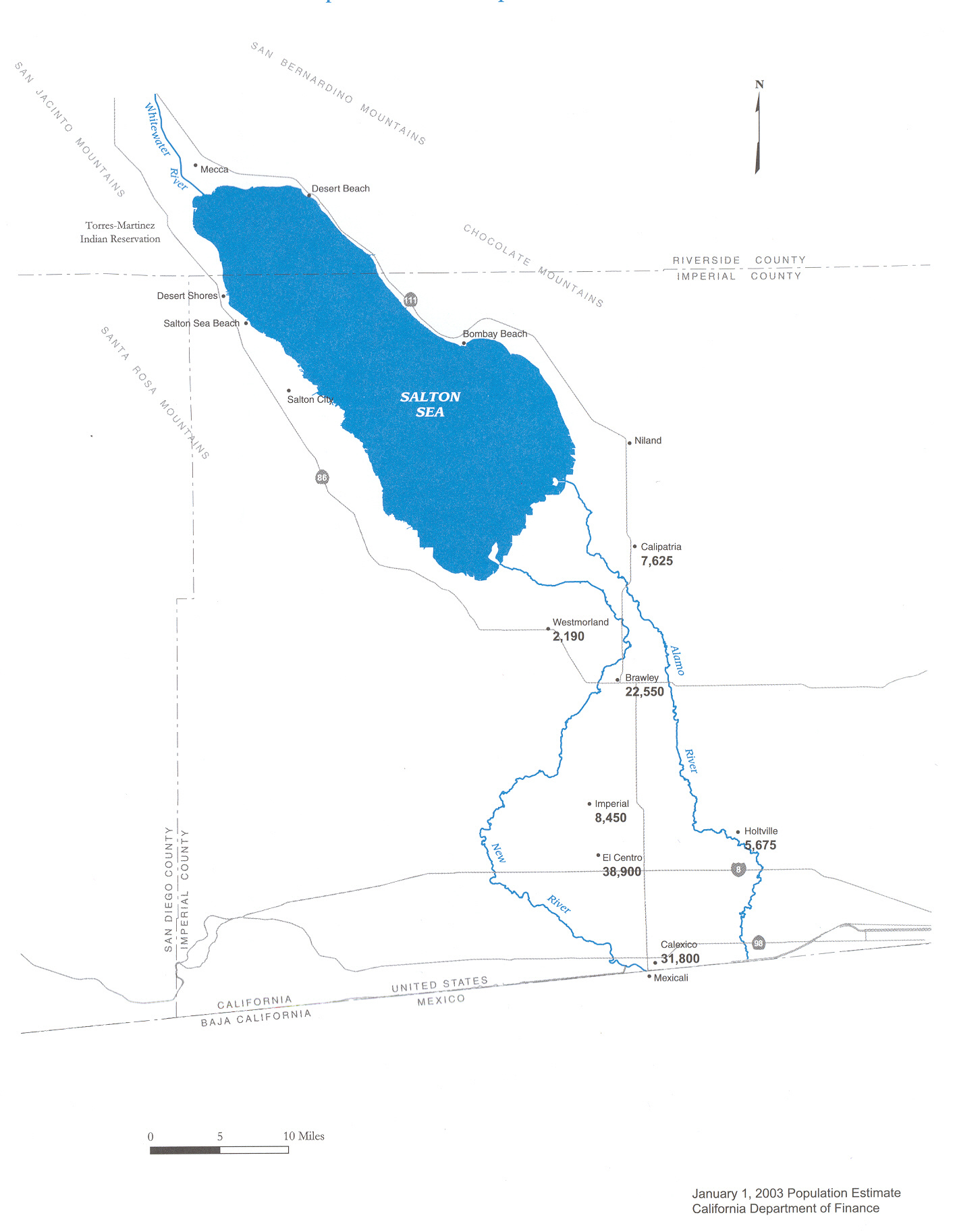
Map of the New River (left) Watershed; Alamo River on the right.Origin near Cerro Prieto[1] 32°22′45″N 115°14′37″W / 32.379164°N 115.243664°W, Mexicali Municipality, Baja California, Mexico Mouth Salton Sea 33°07′53″N 115°41′40″W / 33.131316°N 115.694479°WCoordinates: 33°07′53″N 115°41′40″W / 33.131316°N 115.694479°W, Imperial County, California, USA Basin countries United States, Mexico Length 125 km (81 mi) Avg. discharge 18 m³/s (600 ft³/s) The New River (Río Nuevo in Spanish) flows north from near Cerro Prieto, through the city of Mexicali, Baja California, Mexico, into the United States through the city of Calexico, California towards the Salton Sea. The river channel has existed since pre-historic times; however, the river as known today was formed from a levee failure that resulted in massive flooding that re-created the Salton Sea. Today, the river flow is not natural, mostly consisting of agricultural runoff, municipal discharge and industrial dumping. The river has been referred to as the most severely polluted river of its size within the United States.[2] Several projects have begun to reduce and mitigate the levels of pollution in the river, including upgrading sewage treatment infrastructure and enclosing the river channel.
Contents
Flow
The New River channel begins at a volcanic lake, near Cerro Prieto.[1] Today this lake feeds the Cerro Prieto Geothermal Power Station. The river flows north 15 miles (25 km) through Baja California and another 66 miles (100 km) through California into the Salton Sea, the largest lake in California. Flow at the border is approximately 200 ft³/s (6 m³/s), and about three times this flow at the Salton Sea because of collected agricultural discharges.
The New River’s flow is composed of waste from agricultural and chemical runoff from the farm industry irrigation in the U.S. (18.4%) and Mexico (51.2%), sewage from Mexicali (29%), and manufacturing plants operating in Mexico (1.4%). By the time the New River crosses the U.S./Mexico border near Calexico, California, the channel contains a stew of about 100 contaminants: volatile organic compounds, heavy metals (including selenium, uranium, arsenic and mercury), and pesticides (including DDT) and PCBs. The waterway also holds the pathogens that cause tuberculosis, encephalitis, polio, cholera, hepatitis and typhoid; levels for many of these contaminants are in violation of United States Environmental Protection Agency (EPA) and Cal/EPA standards by several hundredfold.[3] Fecal coliform bacteria are at levels of 100,000 to 16 million colonies per milliliter at the border checkpoint (possibly more, as this is the measuring capacity threshold), far above the U.S.-Mexico treaty limit of 240 colonies.[4][5]
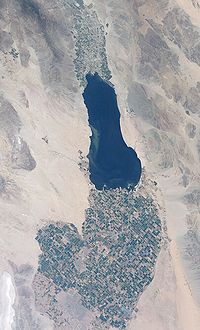
The combined effects of increasing, highly polluted inflow from the New River and agricultural runoff have resulted in elevated bacterial levels and large algal blooms in the Salton Sea. With the lack of an outlet, salinity has increased by approximately 1% per year. Due to high selenium levels, the public was strictly advised to limit fish consumption from the Salton Sea in 1986, after which any amount was likely a health risk. Increasing water temperature, salinity and bacterial levels led to massive fish die-offs (1992, 1994, 1996, 1999, 2006, 2008), and created the ideal breeding grounds for Botulismavian botulism, cholera and Newcastle disease, which also led to massive avian epizootics from 1992-2008. Currently, the Salton Sea has a salinity of 4.4% (4.4 parts per 100), making it saltier than ocean water (3.5% for Pacific), and many species of fish are no longer able to reproduce or survive in the Salton Sea. It is now believed the tilapia may be the only fish species able to persist there for a limited time. Without restoration actions, the sea will likely increase in toxicity, and remain an ecological trap for avian species.
History
The creation of the New River, Alamo River, and Salton Sea of today started in the autumn of 1904 when heavy rainfall and snow-melt caused the Colorado River to swell, overrunning a set of headgates for the Alamo Canal.[1] The resulting flood poured down the canal and breached an Imperial Valley dike. The sudden influx of water and the lack of drainage from the basin resulted in the formation of the Salton Sea; the rivers had re-created a great inland sea in the Salton Sink, an area which had frequently been inundated before. Nearly two years passed before workers could control the Colorado River’s flow and stop the flooding, but the river was effectively dammed in the early part of 1907 and returned to its normal course.[1] The flood significantly enlarged the channels of the New and Alamo Rivers. Some water continued to flow, even after the dike was repaired, as the larger channels collected and carried agricultural runoff to the Salton Sea.[1]
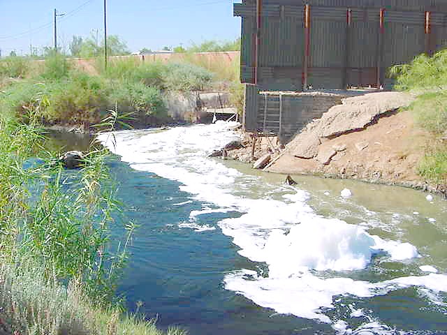
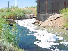 The New River at the International Boundary, carrying foam and mixing with wastewater from the International Drain
Although thorough documentation of the pollution prior to 1960 is not available, records show the New River identified as a significant water pollution problem since the late 1940s. It had such extremely high concentrations of fecal coliform bacteria that it had a stench at its entry to the U.S. Under provisions of the 1944 Water Treaty with Mexico, the governments of the United States and Mexico agreed to give preferential attention to the solution of all border sanitation problems. The International Boundary and Water Commission (IBWC) was first authorized by the two governments to study pollution of the New River from Mexico.
Studies in 1947 and 1948 to correct the New River problem resulted in the recommendation by IBWC that a joint plant be constructed in the United States to treat the sewage of the cities of Calexico and Mexicali.[2]
As Mexicali had a population explosion in the 1970s, and increased pollution levels because of an inadequate sewer infrastructure, the nations made various attempts in the 1980s and 1990s to address pollution of this river, as documented by the International Boundary and Water Commission of the U.S. Department of State.[6][7][8]
Since the passing of the North American Free Trade Agreement (NAFTA) in the 1990s, industrial manufacturing also became an increasingly significant contributor to pollution. Mexico's relatively lax environmental regulations on manufacturing plants or maquiladoras has allowed the plants to use the New River as an industrial waste drainage system over the years. Mexicali has become a bustling border city with over one hundred maquiladoras.
In the 1990s, a joint project was implemented to improve Mexicali's wastewater infrastructure, but although the EPA paid for 55 percent of a $50 million addition to Mexicali's sewage treatment facilities and refurbishing of equipment, the improvements would not treat all the waste discharges to the river. The nations have yet to tackle the residual pollution affecting Mexico and which has also been carried across the border through the Imperial Valley and deposited in the Salton Sea.[4]
Environmental justice
The stench of the New River near the boundary is often overpowering, particularly at night and during the summer when temperatures can reach 120°F. The New River is so heavily polluted that technicians usually wear two sets of gloves, aprons and other protective clothing when testing the water. Discarded tires, trash, dead animals and other wastes line the channel, foam blows into the streets of one of Calexico’s residential areas and toward its downtown area, mosquitoes and other pests thrive during the summer season; all of these factors only serve to elevate contagion risk.
Scores of illegal immigrants are also exposed as they use the river to enter the U.S. Those who succeed in crossing will rarely receive adequate medical attention or screening; and they will often find jobs in the agricultural or food service industries, carrying New River diseases to their various destinations in California and across the U.S.[9] The pollution problem is expected to worsen if Mexicali’s population of about 1.3 million continues to expand without adequate infrastructure.
In 2006, through another binational project, Mexicali finished building a second water treatment facility to treat the 10 to 20 million US gallons (76,000 m3) per day of raw and partially treated sewage that was being discharged into the river. In May, 2005, the New River was designated as one of two environmental justice water quality pilot projects for the State of California Environmental Protection Agency (CalEPA) to try to address the various pollution sources collaboratively between the various stakeholders.[10]
Legislative Changes: SB 387
On July 25, 2005, Governor of California Arnold Schwarzenegger signed Senate Bill 387, introduced by Senator Denise Moreno Ducheny (D-San Diego), which provided funding for the New River Improvement Project. It involves four main components:
- A trash screen;
- Construction of an enclosed box culvert alongside the current river channel through the developed areas of Calexico so that normal flow can be re-routed into the culvert, thereby eliminating resident exposure and allowing for treatment of contaminated flows;
- Construction of wetlands to address overall pollution, including pollution from sources in the United States; and
- Construction of green belts and recreational facilities in a restored New River floodplain.[11][12]
Outlook
According to the Colorado River Regional Water Quality Control Board, once the new waste water treatment facility is fully operational, it will be handling the 10 to 20 million US gallons (38,000 to 76,000 m3) per day of raw sewage currently being discharged into the New River. While this should result in measurable improved water quality of the New River at the border, particularly as it relates to pathogens and nutrients, the binational projects fail to address other problems that have significant adverse impacts on New River water quality at the border. More specifically, the projects do not address the indiscriminate dumping of trash into the New River and its tributaries, the nutrients and pathogens from Mexicali's Zaragoza wastewater treatment lagoons, the untreated and partially treated discharges of industrial wastes, agricultural runoff from the Mexicali Valley, and urban and storm runoff from the municipality.
Moreover, Mexico intends to reclaim the effluent from the treatment plant on onsite green belts. This will result in a 20 million US gallons (76,000 m3) per day decrease in flow of the New River at the border. This loss of flow, coupled with the projected 10 million US gallons (38,000 m3) per day decrease in flow in the river at the border when the InterGen and Sempra Energy power plants reach capacity in Mexicali, the estimated decrease in flow due to projects pursuant to the terms of the Quantification Settlement Agreement, and the water transfer between the Imperial Irrigation District and the San Diego County Water Authority will have devastating water quality impacts on the Salton Sea.[4]
See also
- United States-Mexico border
References
- ^ a b c d e Laflin, Pat. "The Salton Sea California's overlooked treasure". Coachella Valley Historical Society. pp. 21–26. http://www.saltonsea.ca.gov/ltnav/library_content/Hydrology/cal_orverlooked_treasure_lafin.pdf. Retrieved 1 June 2010.
- ^ a b "New River Pollution in Mexico, A Historical Overview" (PDF). Regional Water Quality Control Board. December 1, 1998. http://www.swrcb.ca.gov/rwqcb7/newriver/Historical/NewRiverHistory.pdf. Retrieved February 16, 2007.[dead link]
- ^ "Agency for Toxic Substances and Disease Registry, Division of Health Assessment and Consultation, Atlanta, Georgia" (PDF). U.S. Department of Health and Human Services. February 28, 1996. http://www.calexiconewriver.com/ed_pdf/usdhhsnewriverpetitionedstudy1996.pdf. Retrieved February 16, 2007.
- ^ a b c "Introduction to the New River/Mexicali Sanitation Program". State Water Resources Control Board (SWRCB). March 6, 2006. Archived from the original on September 30, 2006. http://web.archive.org/web/20060930122802/http://www.swrcb.ca.gov/rwqcb7/newriver/nr-intro.html. Retrieved February 16, 2007.
- ^ "New River Water Quality Data". Colorado River Basin Regional Water Quality Control Board. June 2005. Archived from the original on September 30, 2006. http://web.archive.org/web/20060930122821/http://www.swrcb.ca.gov/rwqcb7/newriver/dataindex.html. Retrieved February 16, 2007.
- ^ "Minute 264: Recommendations for solution of the New River border sanitation problem" (PDF). International Boundary and Water Commission. August 26, 1980. http://www.ibwc.state.gov/Files/Minutes/Min264.pdf. Retrieved February 16, 2007.
- ^ "Minute 274: Joint Project for Improvement of the Quality of the Waters of the New River" (PDF). International Boundary and Water Commission. April 15, 1987. http://www.ibwc.state.gov/Files/Minutes/Min274.pdf. Retrieved February 16, 2007.
- ^ "Minute 288: Conceptual Plan for the Long Term Solution to the Border Sanitation Problem of the New River" (PDF). International Boundary and Water Commission. October 30, 1992. http://www.ibwc.state.gov/Files/Minutes/Min288.pdf. Retrieved February 16, 2007.
- ^ Calexico New River Committee (CNRC)
- ^ "CalEPA Environmental Justice Action Plan, Pilot Project Summary on Water New River (Calexico)" (PDF). State Water Resources Control Board SWRCB. May 18, 2005. http://www.calepa.ca.gov/EnvJustice/ActionPlan/PhaseI/June2005/NewRiver051805.pdf. Retrieved February 16, 2007.
- ^ "CNRC Press Release - Governor Schwarzenegger Signs SB 387". Calexico New River Committee. July 27, 2005. http://www.calexiconewriver.com/index.php?build=view&idr=80&page=7&pid=11. Retrieved August 17, 2009.
- ^ "Senate Bill 387 Senator Denise Moreno Ducheny". California State Senate. November 18, 2005. http://info.sen.ca.gov/cgi-bin/postquery?bill_number=sb_387&sess=PREV&house=B&site=sen. Retrieved February 16, 2007.
External links
- New River - Most Polluted River in North America (video documentary)
- "Troubled Waters", a PBS Documentary on the New River by California Connected, June 2, 2006
Categories:- Baja California
- Environmental disasters in the United States
- Mexicali
- Rivers of Southern California
- Rivers of Mexico
- Lower Colorado River Valley
- Geography of the Colorado Desert
- Rivers of Imperial County, California
- Engineering failures
- Disasters in California
- International rivers of North America

Wikimedia Foundation. 2010.