- Mexicali Municipality, Baja California
-
Mexicali Municipality
Municipio de Mexicali— Municipality — 
Coat of armsMotto: Tierra Cálida
(English: Warm Land)Location of Mexicali in Baja California.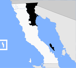
Country Mexico State Baja California Municipal seat Mexicali Largest city Mexicali Municipality established December 29, 1953[1] Government – Municipal president Rodolfo Váldez (PAN) Area – Total 13,700 km2 (5,289.6 sq mi) Population (2010) – Total 956,826 – Density 69.8/km2 (180.9/sq mi) Data source: INEGI Time zone PST (UTC-8) – Summer (DST) PDT (UTC-7) INEGI code 002 Website (Spanish) Ayuntamiento de Mexicali Source: Enciclopedia de los Municipios de México Mexicali Municipality is a municipality (Spanish: municipio) in the Mexican state of Baja California. Its municipal seat (Spanish: cabecera municipal) is located in the city of Mexicali. According to the 2010 census, it had a population of 956,826 inhabitants, and according to the 2000 census, it had 764,602 inhabitants, which means an increase of 22.5%. The municipality has an area of 13,700 km² (5,300 sq mi.) This includes many smaller outlying communities as well as the city of Mexicali. Also, the islands of Baja California located in the Gulf of California are part of the municipality, among them the mudflat islands at the mouth of the Colorado River (the largest one being Montague Island), Isla Ángel de la Guarda and the islands of the San Lorenzo Marine Archipelago National Park. Mexicali is the northernmost municipality of Latin America.
The city of Mexicali was founded in 1903, and its name is a portmanteau of Mexico and California, as is the name of Calexico, California across the border. This is an unusual pair of border cities in that Mexicali, on the Mexican side, is far larger than Calexico, on the U.S. side.
Contents
Boroughs
The municipality of Mexicali, is divided into 14 administrative boroughs (Spanish: delegaciones) of which the city of Mexicali occupies 3 beside the city proper area; all boroughs are in turn divided into colonias or ejidos. These boroughs offer administrative services such as urban planning, civil registry, inspection, verification, public works and community development and are served by a delegado.
The boroughs of Mexicali Municipality city are:
- Los Algodones, located in the Valley Zone.
- Bátaquez, located in the Valley Zone.
- Cerro Prieto, located in the Urban Zone, is part of the Mexicali metropolitan area.
- Venustiano Carranza, located in the Valley Zone.
- Ciudad Morelos, informally known as Cuervos, located in the Valley Zone.
- Colonias Nuevas, informally known as Km 57, located in the Valley Zone.
- Progreso, located in the Urban Zone, is part of the Mexicali metropolitan area.
- Ejido Hermosillo, located in the Valley Zone.
- Estación Delta, located in the Valley Zone.
- Guadalupe Victoria, informally known as Km 43, located in the Valley Zone.
- González Ortega, informally known as Palaco, located in the Urban Zone, is part of the Mexicali metropolitan area.
- Hechicera, located in the Valley Zone.
- San Felipe, located in the Coastal Zone, to the south on the Gulf of California.
- Benito Juárez, informally known as Tecolotes, located in the Valley Zone.
The former borough (delegación) of Compuertas is located in the eastern part of the city of Mexicali.
Cities and towns
Towns and villages
The largest localities (cities, towns, and villages) are:[2]
Name 2010 Census Population Mexicali 689,775 Santa Isabel 29,311 Ciudad Guadalupe Victoria (Kilómetro Cuarenta y Tres) 17,119 San Felipe 16,702 Puebla 15,168 Progreso 12,557 Ciudad Morelos (Cuervos) 8,243 Colonia Venustiano Carranza (La Carranza) 6,098 Ciudad Coahuila (Kilómetro Cincuenta y Siete) 5,617 Vicente Guerrero (Los Algodones) 5,474 Delta (Estación Delta) 5,180 Ejido Hermosillo 5,101 Benito Juárez (Ejido Tecolotes) 4,167 Nuevo León 3,655 Poblado Paredones 3,332 Michoacán de Ocampo 3,086 Ejido Hechicera 2,517 Viñas del Sol 2,509 Ejido Sinaloa (Estación Kasey) 2,505 Ejido Lázaro Cárdenas (La Mosca) 2,463 Poblado Lázaro Cárdenas (La Veintiocho) 2,388 Ejido Quintana Roo 2,311 Total Municipality 936,826 Adjacent municipalities and counties
- San Luis Río Colorado Municipality, Sonora - east
- Ensenada Municipality - south and southwest
- Tecate Municipality - west
- Imperial County, California - north
- Yuma County, Arizona - northeast
See also
References
- ^ (Spanish) pp. 78–79, La Transformación de Baja California en Estado, 1931–1952, Lawrence Douglas Taylor Hansen, Estudios Fronterizos, 1, #1 (Jan-June 2000), UABC, Mexicali, pp. 47–87.
- ^ 2010 census tables: INEGI
- (Spanish) Link to tables of population data from the 2005 Census, INEGI: Instituto Nacional de Estadística, Geografía e Informática.
- (Spanish) Mexicali, Enciclopedia de los Municipios de México, Instituto Nacional Para el Federalismo y el Desarrollo Municipal, SEGOB. Accessed on line November 15, 2007.
- (Spanish) Ubicación Geográfica, Mexicali government web site. Describes subdivisions of Mexicali.
External links
- (Spanish) Ayuntamiento de Mexicali, official government web site.
- (English)/(Spanish) Mexicali Tourism Guide
 State of Baja California
Major cities 
Regions Baja California Desert · Baja California Gold Coast · Colorado River Delta · Sierra Juárez and San Pedro Mártir pine-oak forests
Metro areas Municipalities Ensenada · Mexicali · Rosarito Beach · Tecate · Tijuana
Categories:


Wikimedia Foundation. 2010.