- South Fork New River
Geobox|River
name = South Fork New River
native_name =
other_name =
other_name1 =
image_size = 300
image_caption =
country = United States
country_
state = North Carolina
state_
region_type = Counties
region = Watauga
region1 = Alleghany
region2 = Ashe
district =
district1 =
city =
city1 =
length_imperial =
length_note =
watershed_imperial =
watershed_note =
discharge_location = Jefferson, NC
discharge_average_imperial = 552
discharge_max_imperial = 2120
discharge_max_note = (1998)
discharge_min_imperial = 227
discharge_min_note = (1986)
discharge_note =United States Geological Survey ; [http://waterdata.usgs.gov/nwis/uv?03161000 USGS 03161000 SOUTH FORK NEW RIVER NEAR JEFFERSON, NC] ; retrieved April 19, 2008.]
source_name = Middle Fork South Fork New River
source_location = Blowing Rock
source_district =
source_region =
source_state = NC
source_country =
source_lat_d = 36
source_lat_m = 07
source_lat_s = 34
source_lat_NS = N
source_long_d = 81
source_long_m = 40
source_long_s = 20
source_long_EW = W
source_elevation_imperial = 3543
source_length_imperial =
source_note =gnis|1013504|Middle South Fork New River]
source1_name = East Fork South Fork New River
source1_location = Watauga County
source1_district =
source1_region =
source1_state = NC
source1_country =
source1_lat_d = 36
source1_lat_m = 10
source1_lat_s = 56
source1_lat_NS = N
source1_long_d = 81
source1_long_m = 36
source1_long_s = 37
source1_long_EW = W
source1_elevation_imperial = 3271
source1_length_imperial =
source1_note =gnis|1010997|East Fork South Fork New River]
source_confluence_location = Boone
source_confluence_district =
source_confluence_region =
source_confluence_state = NC
source_confluence_country =
source_confluence_lat_d = 36
source_confluence_lat_m = 12
source_confluence_lat_s = 16
source_confluence_lat_NS = N
source_confluence_long_d = 81
source_confluence_long_m = 38
source_confluence_long_s = 59
source_confluence_long_EW = W
source_confluence_elevation_imperial = 3104
mouth_name = New River
mouth_location = Ashe County
mouth_district =
mouth_region =
mouth_state = NC
mouth_country =
mouth_lat_d = 36
mouth_lat_m = 32
mouth_lat_s = 46
mouth_lat_NS = N
mouth_long_d = 81
mouth_long_m = 21
mouth_long_s = 11
mouth_long_EW = W
mouth_elevation_imperial = 2546
mouth_note =Gnis|1015692|South Fork New River]
tributary_left =
tributary_left1 =
tributary_right =
tributary_right1 =
free_name =
free_value =
map_size = 300
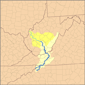
map_caption = Map of theKanawha River watershed, with the New River and its watershed highlighted.The South Fork New River is a
river in theU.S. state ofNorth Carolina .It stretches from its headwaters at a spring near Blowing Rock and the
Eastern Continental Divide and meanders northward along the nortwestern face of theBlue Ridge Mountains through the eastern and central portions of Watauga County and then Ashe County in northwestern North Carolina, passing through the town of Boone. It joins theNorth Fork New River in Ashe County to form the New River. Its waters ultimately reach the Gulf of Mexico through theKanawha River , theOhio River , and theMississippi River . Its tributaries includeWinkler's Creek , Boone (Kraut) Creek andPayne Branch .ee also
*New River
*North Fork New River References

Wikimedia Foundation. 2010.