- Moonachie, New Jersey
-
Borough of Moonachie, New Jersey — Borough — Map highlighting Moonachie's location within Bergen County. Inset: Bergen County's location within New Jersey.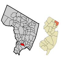 Census Bureau map of Moonachie, New Jersey
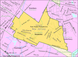
Coordinates: 40°50′33″N 74°3′32″W / 40.8425°N 74.05889°WCoordinates: 40°50′33″N 74°3′32″W / 40.8425°N 74.05889°W Country United States State New Jersey County Bergen Incorporated May 3, 1910 Government – Type Borough (New Jersey) – Mayor Frederick Dressel (D, 2010) – Administrator Anthony Ciannamea[1] Area – Total 1.7 sq mi (4.5 km2) – Land 1.7 sq mi (4.5 km2) – Water 0.0 sq mi (0.0 km2) Elevation[2] 7 ft (2 m) Population (2010)[3] – Total 2,708 – Density 1,558.6/sq mi (601.8/km2) Time zone Eastern (EST) (UTC-5) – Summer (DST) EDT (UTC-4) ZIP code 07074 Area code(s) 201 FIPS code 34-47700[4][5] GNIS feature ID 0885307[6] Website http://www.moonachie.us Moonachie (pronounced moo-NAH-kee, /muːˈnɑːkiː/) is a borough in Bergen County, New Jersey, in the Hackensack River watershed. As of the 2010 United States Census, the borough population was 2,708.[3]
Moonachie was incorporated as a borough by an Act of the New Jersey Legislature on April 11, 1910, from portions of Lodi Township, based on the results of a referendum held on May 3, 1910. On March 26, 1917, portions of Moonachie were taken to form Teterboro.[7] Legend is that Moonachie was named after Chief Monaghie, a member of the Iroquois who inhabited the local cedar forests.[8]
The name of the borough is typically pronounced either "MOON-a-kee" or "moo-NAH-kee;" however, in January 1987, then-New York City Mayor Ed Koch pronounced it "mah-NOO-chee" when he made his now-famous quip that the New York Giants should hold their victory parade in front of the borough's oil drums after the team had just won the Super Bowl. (Koch refused to grant the Giants permission to hold a parade within the city limits because the team plays its home games in New Jersey and not in New York City or even New York State.)[9]
Contents
Geography
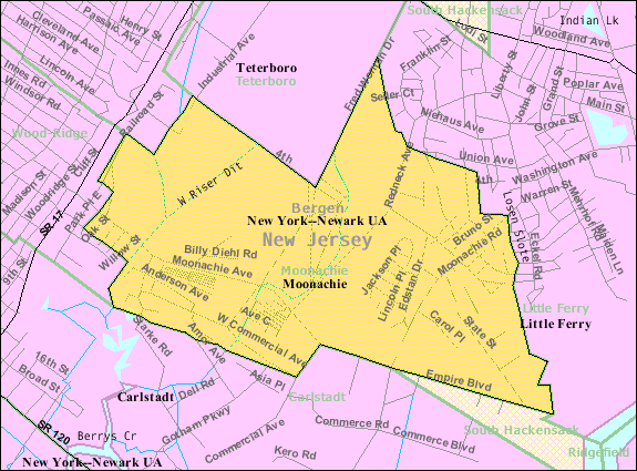
Moonachie is located at 40°50′30″N 74°03′32″W / 40.841668°N 74.059009°W (40.841668, -74.059009)[10], and is approximately 9 miles (14 km) northwest of downtown Manhattan in New York City. Nearby is East Rutherford, in which can be found the Meadowlands Sports Complex, home to the National Football League's New York Giants and New York Jets, and a racetrack at which both thoroughbred horse racing and harness racing are conducted.
According to the United States Census Bureau, the borough has a total area of 1.7 square miles (4.4 km2), all of it land. The borough's ZIP code is 07074.
Demographics
Historical populations Census Pop. %± 1900 212 — 1910 638 200.9% 1920 1,194 87.1% 1930 1,465 22.7% 1940 1,554 6.1% 1950 1,775 14.2% 1960 3,052 71.9% 1970 2,951 −3.3% 1980 2,706 −8.3% 1990 2,817 4.1% 2000 2,754 −2.2% 2010 2,708 −1.7% Population 1930 - 1990.[11][12] As of the census[4] of 2000, there were 2,754 people, 1,041 households, and 707 families residing in the borough. The population density was 1,596.5 people per square mile (614.6/km2). There were 1,074 housing units at an average density of 622.6 per square mile (239.7/km2). The racial makeup of the borough was 85.66% White, 0.94% African American, 0.11% Native American, 6.64% Asian, 2.94% from other races, and 3.70% from two or more races. Hispanic or Latino of any race were 12.67% of the population.
There were 1,041 households out of which 28.1% had children under the age of 18 living with them, 52.6% were married couples living together, 10.8% had a female householder with no husband present, and 32.0% were non-families. 27.8% of all households were made up of individuals and 11.4% had someone living alone who was 65 years of age or older. The average household size was 2.65 and the average family size was 3.27.
In the borough the population was spread out with 20.9% under the age of 18, 7.6% from 18 to 24, 30.1% from 25 to 44, 26.1% from 45 to 64, and 15.3% who were 65 years of age or older. The median age was 40 years. For every 100 females there were 96.9 males. For every 100 females age 18 and over, there were 95.6 males.
The median income for a household in the borough was $50,571, and the median income for a family was $62,163. Males had a median income of $41,875 versus $32,829 for females. The per capita income for the borough was $24,654. About 1.7% of families and 3.8% of the population were below the poverty line, including 3.8% of those under age 18 and 6.3% of those age 65 or over.
Government
Local government
Moonachie is governed under the Borough form of New Jersey municipal government. The government consists of a Mayor and a Borough Council comprising six council members, with all positions elected at large. A Mayor is elected directly by the voters to a four-year term of office and only votes to break a tie. The Borough Council consists of six members elected to serve three-year terms on a staggered basis, with two seats coming up for election each year.[13]
Moonachie's Mayor is Frederick Dressel. Moonachie's Borough Council is composed of George Cahill (D, 2008), George Collazo (D, 2009), Maureen Flynn (D, 2008), Kathy Kinsella (D, 2010), Bruce Surak (D, 2009) and Dennis Vaccaro (D, 2010).[1][14]
On November 6, 2007. Democratic incumbents Kathy Kinsella and Dennis Vaccaro ran unopposed in their bids for additional three-year terms.[15]
On Election Day, November 7, 2006, voters selected a Mayor for a four-year term, filled two three-year seats up for election on the Borough Council and voted on a ballot question. As of Election Day, the council was filled with six Democrats, in a community in which registered Democrats outnumber Republicans by a better than 3-2 margin. The Democratic incumbents all ran unopposed, with Frederick J. Dressel (445 votes) winning reelection as Mayor, and councilmembers George Collazo (432) and Bruce Surak (435) winning new terms. Voters approved the establishment of a Length of Service Awards Program by a 270-147 margin.[16][17][18] The qualifications to serve in the Moonachie Borough Council include being at least 18 years old, a high school graduate, and a resident.
Federal, state and county representation
Moonachie is in the 9th Congressional district. New Jersey's Ninth Congressional District is represented by Steve Rothman (D, Fair Lawn). New Jersey is represented in the United States Senate by Frank Lautenberg (D, Cliffside Park) and Bob Menendez (D, Hoboken).
Moonachie is in the 36th District of the New Jersey Legislature, which is represented in the New Jersey Senate by Paul Sarlo (D, Wood-Ridge) and in the New Jersey General Assembly by Gary Schaer (D, Passaic) and Kevin J. Ryan (D, Nutley).[19]
Bergen County's County Executive is Kathleen Donovan (R, Rutherford; term ends December 31, 2014).[20] The Board of Chosen Freeholders is the county's legislative body and its seven members are elected at-large on a staggered basis, with two or three seats coming up for election each year.[21] As of 2011, Bergen County's Freeholders are Chairman John Driscoll, Jr. (R, 2012; Paramus),[22] Vice-Chairwoman Maura DeNicola (R, 2013; Franklin Lakes),[23] Chair Pro Tempore John D. Mitchell (R, 2013; Cliffside Park)[24] John A. Felice (R, 2013; River Edge),[25] David L. Ganz (D, 2011; Fair Lawn),[26] Robert G. Hermansen (R, 2012; Mahwah)[27] and Bernadette P. McPherson (D, 2011; Rutherford).[28][29] Other countywide constitutional officials are Sheriff Michael Saudino (R), Surrogate Michael R. Dressler (D, Cresskill) and County Clerk Elizabeth Randall (R, Westwood).[30]
Politics
As of April 1, 2006, out of a 2004 Census estimated population of 2,816 in Moonachie, there were 1,473 registered voters (52.3% of the population, vs. 55.4% in all of Bergen County). Of registered voters, 333 (22.6% vs. 20.7% countywide) were registered as Democrats, 185 (12.6% vs. 19.2% countywide) were registered as Republicans and 955 (64.8% vs. 60.1% countywide) were registered as Undeclared. There were no voters registered to other parties.[31]
On the national level, Moonachie is almost evenly split. In the 2004 presidential election, Republican George W. Bush received 50% of the vote here, edging Democrat John Kerry, who received around 49%.[32]
Education
Public school students in Pre-Kindergarten through eighth grade attend the Robert L. Craig School which served 281 students (based on 2005-06 enrollment data from the National Center for Education Statistics) as part of the Moonachie School District.[33]
For grades nine through twelve, public school students attend Wood-Ridge High School in Wood-Ridge, as part of a sending/receiving relationship with the Wood-Ridge School District.[34]
Transportation
County Route 503 passes through Moonachie as Moonachie Road.
New Jersey Transit bus routes 76, 144, 145, 148, 160, 161, 163, 164, 703 and 772 serve Moonachie.[35]
Portions of Teterboro Airport are located in Moonachie.[36]
References
- ^ a b "County of Bergen: 2008 County and Municipal Directory", Bergen County, New Jersey, p. 53. Accessed July 5, 2008.
- ^ U.S. Geological Survey Geographic Names Information System: Borough of Moonachie, Geographic Names Information System, accessed December 25, 2007.
- ^ a b "Race, Hispanic or Latino, Age, and Housing Occupancy: 2010 Census Redistricting Data (Public Law 94-171) Summary File (QT-PL), Moonachie borough, New Jersey". U.S. Census Bureau, American FactFinder 2. http://factfinder2.census.gov. Retrieved August 3, 2011.
- ^ a b "American FactFinder". United States Census Bureau. http://factfinder.census.gov. Retrieved 2008-01-31.
- ^ A Cure for the Common Codes: New Jersey, Missouri Census Data Center. Accessed July 14, 2008.
- ^ "US Board on Geographic Names". United States Geological Survey. 2007-10-25. http://geonames.usgs.gov. Retrieved 2008-01-31.
- ^ "The Story of New Jersey's Civil Boundaries: 1606-1968", John P. Snyder, Bureau of Geology and Topography; Trenton, New Jersey; 1969. p. 81.
- ^ Borough of Moonachie official website
- ^ Vescey, George. "SPORTS OF THE TIMES; How'm I Doing? Terrific", The New York Times, January 7, 1987. Accessed October 10, 2007. "He said he thought they made a very nice cheesesteak sandwich in Moonachie, which he pronounced mah-NOO-chee instead of moo-NAH-key."
- ^ "US Gazetteer files: 2010, 2000, and 1990". United States Census Bureau. 2011-02-12. http://www.census.gov/geo/www/gazetteer/gazette.html. Retrieved 2011-04-23.
- ^ New Jersey Resident Population by Municipality: 1930 - 1990, Workforce New Jersey Public Information Network. Accessed March 1, 2007.
- ^ Historical Population Trends in Bergen County (1900 - 2000), Bergen County, New Jersey. Accessed December 23, 2007.
- ^ 2005 New Jersey Legislative District Data Book, Rutgers University Edward J. Bloustein School of Planning and Public Policy, April 2005, p. 154.
- ^ Borough of Moonachie Government, Borough of Moonachie. Accessed October 10, 2007.
- ^ "BERGEN COUNTY Unofficial Results", The Record (Bergen County), November 7, 2007. Accessed November 7, 2007.
- ^ Moonachie Election guide, The Record (Bergen County), November 1, 2006.
- ^ "Election 2006 Municipal Results", The Record (Bergen County), November 8, 2006.
- ^ Bergen County 2006 General Election Results, Bergen County, New Jersey. Accessed February 1, 2007.
- ^ "Legislative Roster: 2010-2011 Session". New Jersey Legislature. http://www.njleg.state.nj.us/members/roster.asp. Retrieved 2010-02-08.
- ^ Bergen County Executive, Bergen County, New Jersey. Accessed January 3, 2011.
- ^ What Is a Freeholder?, Bergen County, New Jersey. Accessed January 6, 2011.
- ^ Freeholder John Driscoll, Jr., Bergen County, New Jersey. Accessed January 11, 2011.
- ^ Maura R. DeNicola, Bergen County, New Jersey. Accessed January 11, 2011.
- ^ John D. Mitchell, Bergen County, New Jersey. Accessed January 11, 2011.
- ^ John A. Felice, Bergen County, New Jersey. Accessed January 11, 2011.
- ^ Freeholder David L. Ganz, Bergen County, New Jersey. Accessed January 11, 2011.
- ^ Freeholder Robert G. Hermansen, Bergen County, New Jersey. Accessed January 11, 2011.
- ^ Freeholder Bernadette P. McPherson, Bergen County, New Jersey. Accessed January 11, 2011.
- ^ Freeholder Home Page, Bergen County, New Jersey. Accessed January 3, 2011.
- ^ Constitutional Officers, Bergen County, New Jersey. Accessed January 3, 2011.
- ^ "County of Bergen: Voter Statistics by Municipality, Ward & District," Bergen County, New Jersey, dated April 1, 2006.
- ^ 2004 Presidential Election results: Bergen County, New Jersey Department of Law and Public Safety: Division of Elections, dated December 13, 2004.
- ^ Data for the Moonachie School District, National Center for Education Statistics. Accessed May 27, 2008.
- ^ Wood-Ridge High School 2007 Report Card Narrative, New Jersey Department of Education. Accessed May 27, 2008. "Wood-Ridge High School is a four year, comprehensive high school with an enrollment of 419 students for the 2006-2007 school year. The district maintains a receiving relationship with the neighboring community of Moonachie, whereby its high school students attend Wood-Ridge High School."
- ^ Routes by County: Bergen County, New Jersey Transit. Accessed August 8, 2008.
- ^ Directions to and from the Airport, Port Authority of New York & New Jersey. Accessed July 7, 2008. "Teterboro Airport is located in the Boroughs of Teterboro, Moonachie, and Hasbrouck Heights in Bergen County, New Jersey."
External links
- Moonachie Borough website
- Robert L. Craig School
- Robert L. Craig School's 2009–10 School Report Card from the New Jersey Department of Education
- Data for the Moonachie School District, National Center for Education Statistics
- Wood Ridge High School's 2009–10 School Report Card from the New Jersey Department of Education
- Moonachie Police Web
- "Pat from Moonachie" Myspace
- Moonachie First Aid and Rescue Squad
Municipalities and communities of Bergen County, New Jersey Cities 
Boroughs Allendale | Alpine | Bergenfield | Bogota | Carlstadt | Cliffside Park | Closter | Cresskill | Demarest | Dumont | East Rutherford | Edgewater | Elmwood Park | Emerson | Englewood Cliffs | Fair Lawn | Fairview | Fort Lee | Franklin Lakes | Glen Rock | Harrington Park | Hasbrouck Heights | Haworth | Hillsdale | Ho-Ho-Kus | Leonia | Little Ferry | Lodi | Maywood | Midland Park | Montvale | Moonachie | New Milford | North Arlington | Northvale | Norwood | Oakland | Old Tappan | Oradell | Palisades Park | Paramus | Park Ridge | Ramsey | Ridgefield | River Edge | Rockleigh | Rutherford | Saddle River | Tenafly | Teterboro | Upper Saddle River | Waldwick | Wallington | Westwood | Wood-Ridge | Woodcliff Lake
Townships Villages Unincorporated
communitiesCategories:- Boroughs in Bergen County, New Jersey
- Place names in New Jersey of Native American origin
- New Jersey Meadowlands District


Wikimedia Foundation. 2010.