- Norwood, New Jersey
-
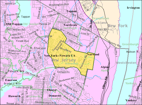
Norwood, New Jersey — Borough — Map highlighting Norwood's location within Bergen County. Inset: Bergen County's location within New Jersey.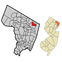 Census Bureau map of Norwood, New Jersey
Coordinates: 40°59′39″N 73°57′4″W / 40.99417°N 73.95111°WCoordinates: 40°59′39″N 73°57′4″W / 40.99417°N 73.95111°W Country United States State New Jersey County Bergen Incorporated March 21, 1905 Government – Type Borough – Mayor James Barsa (R, 2011) Area – Total 2.8 sq mi (7.1 km2) – Land 2.7 sq mi (7.1 km2) – Water 0.0 sq mi (0.0 km2) Elevation[1] 30 ft (9 m) Population (2010)[2] – Total 5,711 – Density 2,083.3/sq mi (804.4/km2) Time zone Eastern (EST) (UTC-5) – Summer (DST) EDT (UTC-4) ZIP code 07648 Area code(s) 201 FIPS code 34-53610[3][4] GNIS feature ID 0885329[5] Website http://www.norwoodboro.org Norwood is a borough in Bergen County, New Jersey, United States. As of the 2010 United States Census, the borough population was 5,711.[2]
Norwood was formed as a borough by an Act of the New Jersey Legislature on March 14, 1905, from portions of Harrington Township.[6]
Contents
History
The territory comprising Norwood was originally settled about 1670 by a dozen or more families mostly from Holland, who purchased the land under the Tappan Patent. About that time a grant was also given by Philip Carteret, Governor of the Province of East Jersey, during the reign of King Charles II of England. The Lenni Lenape Native Americans roamed the valley.[7]
The name Norwood emanated from the old description “North-Woods”. It was a part of Harrington Township, which was formed in 1775 from the northernmost portions of Hackensack Township and New Barbadoes Township, stretching from the Hudson River in the east to the Saddle River in the west.[7]
In 1840, the portions of Harrington Township west of the Hackensack River were taken away to create Washington Township. At that point, Harrington Township was somewhat in the form of a square measuring across each way about 5 miles (8 km), bounded on the north by Rockland County, New York; east by the Hudson River, south by Hackensack Township and west by the Hackensack River. At that time, Norwood, Northvale (once called Neuvy), Old Tappan, Demarest, Closter and Harrington Park formed Harrington Township.[7]
On March 14, 1905, Norwood seceded from its parent Harrington Township.[6][7]
Geography
Norwood is located at 40°59′40″N 73°57′21″W / 40.994442°N 73.955866°W (40.994442, -73.955866).[8]
According to the United States Census Bureau, the borough has a total area of 2.8 square miles (7.3 km2), of which 0.36% is water.
Norwood occupies 768 acres (3.11 km2) in Bergen County, in the northeastern part of New Jersey, about 2 miles (3 km) from the New York state line. It is bounded by the boroughs of Northvale, Old Tappan, Harrington Park, Closter, Alpine and Rockleigh.
Demographics
Historical populations Census Pop. %± 1900 400 — 1910 564 41.0% 1920 820 45.4% 1930 1,358 65.6% 1940 1,512 11.3% 1950 1,792 18.5% 1960 2,852 59.2% 1970 4,398 54.2% 1980 4,413 0.3% 1990 4,858 10.1% 2000 5,751 18.4% 2010 5,711 −0.7% Population 1900 - 1990.[9][10] As of the census[3] of 2000, there were 5,751 people, 1,857 households, and 1,563 families residing in the borough. The population density was 2,091.4 people per square mile (807.4/km2). There were 1,888 housing units at an average density of 686.6 per square mile (265.1/km2). The racial makeup of the borough was 77.86% White, 0.83% African American, 0.02% Native American, 18.99% Asian, 0.94% from other races, and 1.36% from two or more races. Hispanic or Latino of any race were 2.99% of the population.
As of the 2000 census, 12.69% of Norwood's residents identified themselves as being of Korean ancestry, which was the eighth highest in the United States and sixth highest of any municipality in New Jersey, for all places with 1,000 or more residents identifying their ancestry.[11]
There were 1,857 households out of which 41.5% had children under the age of 18 living with them, 73.8% were married couples living together, 7.8% had a female householder with no husband present, and 15.8% were non-families. 13.7% of all households were made up of individuals and 6.0% had someone living alone who was 65 years of age or older. The average household size was 2.97 and the average family size was 3.26.
In the borough the population was spread out with 25.8% under the age of 18, 5.4% from 18 to 24, 26.9% from 25 to 44, 26.4% from 45 to 64, and 15.6% who were 65 years of age or older. The median age was 41 years. For every 100 females there were 88.7 males. For every 100 females age 18 and over, there were 84.4 males.
The median income for a household in the borough was $92,447, and the median income for a family was $100,329. Males had a median income of $70,000 versus $37,059 for females. The per capita income for the borough was $40,039. About 2.3% of families and 4.9% of the population were below the poverty line, including 6.4% of those under age 18 and 2.9% of those age 65 or over.
Government
Local government
Norwood is governed under the Borough form of New Jersey municipal government. The government consists of a Mayor and a Borough Council comprising six council members, with all positions elected at large. A Mayor is elected directly by the voters to a four-year term of office and only votes to break a tie. The Borough Council consists of six members elected to serve three-year terms on a staggered basis, with two seats coming up for election each year.[12]
The Mayor of Norwood is James Barsa (R, term of office ends December 31, 2011). Members of the Borough Council are Council President Ed Condoleo (R, 2010), John A Nicolai (R, 2012), Frank Marino (R, 2012), Barry Scott (R, 2011), Marianne Orechio (R, 2011) and Allen Rapaport (R, 2010).
In elections held on November 3, 2009, voters elected incumbent Councilman John A Nicolai (R, 2012), a Pension Consultant and Firearms Instructor who was appointed to the Council by Mayor Barsa in May 2009. Also elected was Frank Marino (R, 2012), a special education teacher and football coach.
The 2009 election had the effect of removing Tom Brizzolara (D), the sole remaining Democrat on the governing body. Norwood’s Council is now composed entirely of Republicans, in a community in which registered Democrats outnumber Republicans by a nearly 7-6 margin.
The final tally, including absentee ballots, had John Nicolai and Frank Marino winning with 1,030 and 950 votes, respectively. Tom Brizzolara and his running mate followed with 924 and 769. Councilman Allen Rapaport was quoted as saying about Brizzolara: "He's a nine-year incumbent, and I have a great deal of respect for him". Stunningly Rapaport went on to say: "I was very surprised that he didn't win. I always thought people would want a watchdog on the council." http://www.northjersey.com/news/69445397.html
The Nicolai/Marino Team ran on a campaign platform of Leaner ~ Greener ~ Healthier which possibly ushered in Governor Chris Christie (R) over incumbent Governor Jon Corzine (D).
Federal, state and county representation
Norwood is in the 5th Congressional district. New Jersey's Fifth Congressional District is represented by Scott Garrett (R, Wantage Township). New Jersey is represented in the United States Senate by Frank Lautenberg (D, Cliffside Park) and Bob Menendez (D, Hoboken).
Norwood is in the 39th Legislative District of the New Jersey Legislature, which is represented in the New Jersey Senate by Gerald Cardinale (R, Demarest) and in the New Jersey General Assembly by Bob Schroeder (R, Washington Township) and Charlotte Vandervalk (R, Hillsdale).[13]
Bergen County's County Executive is Kathleen Donovan (R, Rutherford; term ends December 31, 2014).[14] The Board of Chosen Freeholders is the county's legislative body and its seven members are elected at-large on a staggered basis, with two or three seats coming up for election each year.[15] As of 2011, Bergen County's Freeholders are Chairman John Driscoll, Jr. (R, 2012; Paramus),[16] Vice-Chairwoman Maura DeNicola (R, 2013; Franklin Lakes),[17] Chair Pro Tempore John D. Mitchell (R, 2013; Cliffside Park)[18] John A. Felice (R, 2013; River Edge),[19] David L. Ganz (D, 2011; Fair Lawn),[20] Robert G. Hermansen (R, 2012; Mahwah)[21] and Bernadette P. McPherson (D, 2011; Rutherford).[22][23] Other countywide constitutional officials are Sheriff Michael Saudino (R), Surrogate Michael R. Dressler (D, Cresskill) and County Clerk Elizabeth Randall (R, Westwood).[24]
Politics
As of April 1, 2006, out of a 2004 Census estimated population of 6,223 in Norwood, there were 3,578 registered voters (57.5% of the population, vs. 55.4% in all of Bergen County). Of registered voters, 715 (20.0% vs. 20.7% countywide) were registered as Democrats, 606 (16.9% vs. 19.2% countywide) were registered as Republicans and 2,256 (63.1% vs. 60.1% countywide) were registered as Undeclared. There was one voter registered to another party.[25]
Education
The Norwood Public School District serves students in kindergarten through eighth grade. Norwood Public School had an enrollment of 638 students as of the 2005-06 school year.[26]
Students in public school for grades 9 - 12 attend Northern Valley Regional High School at Old Tappan one of the two schools of the Northern Valley Regional High School District, which serves a total of approximately 2,500 students from the neighboring communities of Closter, Demarest, Harrington Park, Haworth, Northvale, Norwood and Old Tappan.
Transportation
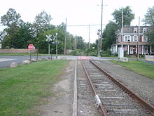 The site of the former Erie Railroad station in Norwood on September 11, 2011
County Route 501 and County Route 505 passes through Norwood.
Wildlife
The forests in Norwood house lots of deciduous species, sheltering deer, wild turkey, turtles, foxes, rabbits, and even coyote. Suburban sprawl is beginning to interfere with the wildlife. Deer and auto collisions as well as coyote and human interaction may be a problem.
Notable residents
Notable current and former residents of Norwood include:
- Bruce Harper (1955-), former running back for the New York Jets.[27]
- Frank Messina (c. 1968-), poet and author.[28]
- Gene Michael (1938-), former player, manager and executive in Major League Baseball.[29]
- Thurman Munson[citation needed]
- Graig Nettles[citation needed]
- Julian Sanchez, libertarian writer, journalist[citation needed]
References
- ^ U.S. Geological Survey Geographic Names Information System: Borough of Norwood, Geographic Names Information System, accessed November 29, 2007.
- ^ a b "Race, Hispanic or Latino, Age, and Housing Occupancy: 2010 Census Redistricting Data (Public Law 94-171) Summary File (QT-PL), Norwood borough, New Jersey". U.S. Census Bureau, American FactFinder 2. http://factfinder2.census.gov. Retrieved August 3, 2011.
- ^ a b "American FactFinder". United States Census Bureau. http://factfinder.census.gov. Retrieved 2008-01-31.
- ^ A Cure for the Common Codes: New Jersey, Missouri Census Data Center. Accessed July 14, 2008.
- ^ "US Board on Geographic Names". United States Geological Survey. 2007-10-25. http://geonames.usgs.gov. Retrieved 2008-01-31.
- ^ a b "The Story of New Jersey's Civil Boundaries: 1606-1968", John P. Snyder, Bureau of Geology and Topography; Trenton, New Jersey; 1969. p. 82.
- ^ a b c d EARLY HISTORY - Reprinted from Norwood Through The Years by Ruth Julich, the book published in 1955 in celebration of the borough’s 50th anniversary, accessed February 21, 2007.
- ^ "US Gazetteer files: 2010, 2000, and 1990". United States Census Bureau. 2011-02-12. http://www.census.gov/geo/www/gazetteer/gazette.html. Retrieved 2011-04-23.
- ^ Historical Population Trends in Bergen County (1900 - 2000), Bergen County, New Jersey. Accessed December 23, 2007.
- ^ New Jersey Resident Population by Municipality: 1930 - 1990, Workforce New Jersey Public Information Network. Accessed March 1, 2007.
- ^ Korean Communities, Epodunk. Accessed December 10, 2007.
- ^ 2005 New Jersey Legislative District Data Book, Rutgers University Edward J. Bloustein School of Planning and Public Policy, April 2005, p. 165.
- ^ "Legislative Roster: 2010-2011 Session". New Jersey Legislature. http://www.njleg.state.nj.us/members/roster.asp. Retrieved 2010-10-22.
- ^ Bergen County Executive, Bergen County, New Jersey. Accessed January 3, 2011.
- ^ What Is a Freeholder?, Bergen County, New Jersey. Accessed January 6, 2011.
- ^ Freeholder John Driscoll, Jr., Bergen County, New Jersey. Accessed January 11, 2011.
- ^ Maura R. DeNicola, Bergen County, New Jersey. Accessed January 11, 2011.
- ^ John D. Mitchell, Bergen County, New Jersey. Accessed January 11, 2011.
- ^ John A. Felice, Bergen County, New Jersey. Accessed January 11, 2011.
- ^ Freeholder David L. Ganz, Bergen County, New Jersey. Accessed January 11, 2011.
- ^ Freeholder Robert G. Hermansen, Bergen County, New Jersey. Accessed January 11, 2011.
- ^ Freeholder Bernadette P. McPherson, Bergen County, New Jersey. Accessed January 11, 2011.
- ^ Freeholder Home Page, Bergen County, New Jersey. Accessed January 3, 2011.
- ^ Constitutional Officers, Bergen County, New Jersey. Accessed January 3, 2011.
- ^ "County of Bergen: Voter Statistics by Municipality, Ward & District," dated April 1, 2006.
- ^ Data for the Norwood Public School, National Center for Education Statistics. Accessed May 27, 2008.
- ^ Rondinaro, Gene. "Picturesque, Affluent West of Palisades", The New York Times, November 3, 1996. Accessed October 8, 2007. "Like Mr. Harper, other sports figures such as Don Mattingly, Gene Michael, Craig Nettles, Jim (Catfish) Hunter and Kenny Anderson have at one time or another called the borough home."
- ^ Beckerman, Jim. "Beckerman: Putting the worst in verse will be tough for him", The Record (Bergen County), October 7, 2007. Accessed October 7, 2007.
- ^ Durso, Joseph. "Most N. Y. Yankees Call N. J. Home", The New York Times, August 20, 1972.
Sources
- "History of Bergen County, New Jersey, 1630-1923;" by Westervelt, Frances A. (Frances Augusta), 1858–1942
- "Municipal Incorporations of the State of New Jersey (according to Counties)" prepared by the Division of Local Government, Department of the Treasury (New Jersey); December 1, 1958
External links
- Borough of Norwood official website
- Norwood Public School
- Norwood Public School's 2009–10 School Report Card from the New Jersey Department of Education
- Data for the Norwood Public School, National Center for Education Statistics
- Northern Valley Regional High School District
Municipalities and communities of Bergen County, New Jersey Cities 
Boroughs Allendale | Alpine | Bergenfield | Bogota | Carlstadt | Cliffside Park | Closter | Cresskill | Demarest | Dumont | East Rutherford | Edgewater | Elmwood Park | Emerson | Englewood Cliffs | Fair Lawn | Fairview | Fort Lee | Franklin Lakes | Glen Rock | Harrington Park | Hasbrouck Heights | Haworth | Hillsdale | Ho-Ho-Kus | Leonia | Little Ferry | Lodi | Maywood | Midland Park | Montvale | Moonachie | New Milford | North Arlington | Northvale | Norwood | Oakland | Old Tappan | Oradell | Palisades Park | Paramus | Park Ridge | Ramsey | Ridgefield | River Edge | Rockleigh | Rutherford | Saddle River | Tenafly | Teterboro | Upper Saddle River | Waldwick | Wallington | Westwood | Wood-Ridge | Woodcliff Lake
Townships Villages Unincorporated
communitiesCategories:- Boroughs in Bergen County, New Jersey


Wikimedia Foundation. 2010.