- Mountain Iron Mine
-
Mountain Iron Mine
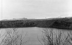
Location: Mountain Iron, Minnesota Coordinates: 47°32′19.7″N 92°37′21.4″W / 47.538806°N 92.622611°WCoordinates: 47°32′19.7″N 92°37′21.4″W / 47.538806°N 92.622611°W Area: 240 acres (97 ha) Built: 1892 Governing body: Privately owned NRHP Reference#: 68000052 Significant dates Added to NRHP: November 24, 1968[1] Designated NHL: October 10, 1968[2] The discovery of Mountain Iron Mine in Mountain Iron, Minnesota in 1890 represents the beginning of the exploitation of the Mesabi Range iron ore in the Iron Range of northeast Minnesota. The Mesabi Range and nearby Vermilion Range led Minnesota to become the nation's largest producer of iron ore and the United States to lead the world in steel production. This capacity is considered to have been a major factor in America's ability to contribute to World War II. It also played a major role in the financial success of Andrew Carnegie and U.S. Steel.[3] Carnegie returned some of his fortune to the communities by funding 2500 public Carnegie Libraries across the country, including 64 in rural Minnesota.
The extraction of ore in the region also contributed to the tiny port city of Duluth thriving and becoming the leading port in the United States (by tonnage) in the early 20th century.
It was listed on the National Register of Historic Places and further designated as a U.S. National Historic Landmark in 1968.[2]
References
- ^ "National Register Information System". National Register of Historic Places. National Park Service. 2007-10-06. http://nrhp.focus.nps.gov/natreg/docs/All_Data.html.
- ^ a b "List of National Historic Landmarks by State" (PDF). National Historic Landmark summary listing. National Park Service. p. 53. http://www.nps.gov/nhl/designations/Lists/LIST07.pdf. Retrieved 2009-09-04.
- ^ Stephen Lissanddrello (August 11, 1975). National Register of Historic Places Inventory-Nomination: Mountain Iron MinePDF (322 KB). National Park Service and Accompanying 3 images from 1975PDF (865 KB)
- Theodore Jones (1997). Carnegie Libraries Across America: A Public Legacy. John Wiley & Sons. ISBN 0-471-14422-3
National Historic Landmarks in Minnesota Landmark homes Landmark commercial enterprises Pillsbury "A" Mill | Washburn "A" Mill | Peavey-Haglin Experimental Concrete Grain Elevator | Plummer Building | Hull-Rust-Mahoning Open Pit Iron Mine | Mountain Iron Mine | Soudan Iron Mine | National Farmer's Bank | St. Croix Boom Site
Military landmark New Deal landmarks Prehistoric landmarks Grand Mound | Kathio Site
Lighthouse Split Rock Lighthouse
U.S. National Register of Historic Places Topics Lists by states Alabama • Alaska • Arizona • Arkansas • California • Colorado • Connecticut • Delaware • Florida • Georgia • Hawaii • Idaho • Illinois • Indiana • Iowa • Kansas • Kentucky • Louisiana • Maine • Maryland • Massachusetts • Michigan • Minnesota • Mississippi • Missouri • Montana • Nebraska • Nevada • New Hampshire • New Jersey • New Mexico • New York • North Carolina • North Dakota • Ohio • Oklahoma • Oregon • Pennsylvania • Rhode Island • South Carolina • South Dakota • Tennessee • Texas • Utah • Vermont • Virginia • Washington • West Virginia • Wisconsin • WyomingLists by territories Lists by associated states Other Categories:- Iron mines in the United States
- Geology of Minnesota
- National Historic Landmarks in Minnesota
- Mines in Minnesota
- Buildings and structures in St. Louis County, Minnesota

Wikimedia Foundation. 2010.