- Blue Mounds State Park
Geobox|Protected area
name = Blue Mounds State Park
category =Minnesota State Park
category_iucn = V
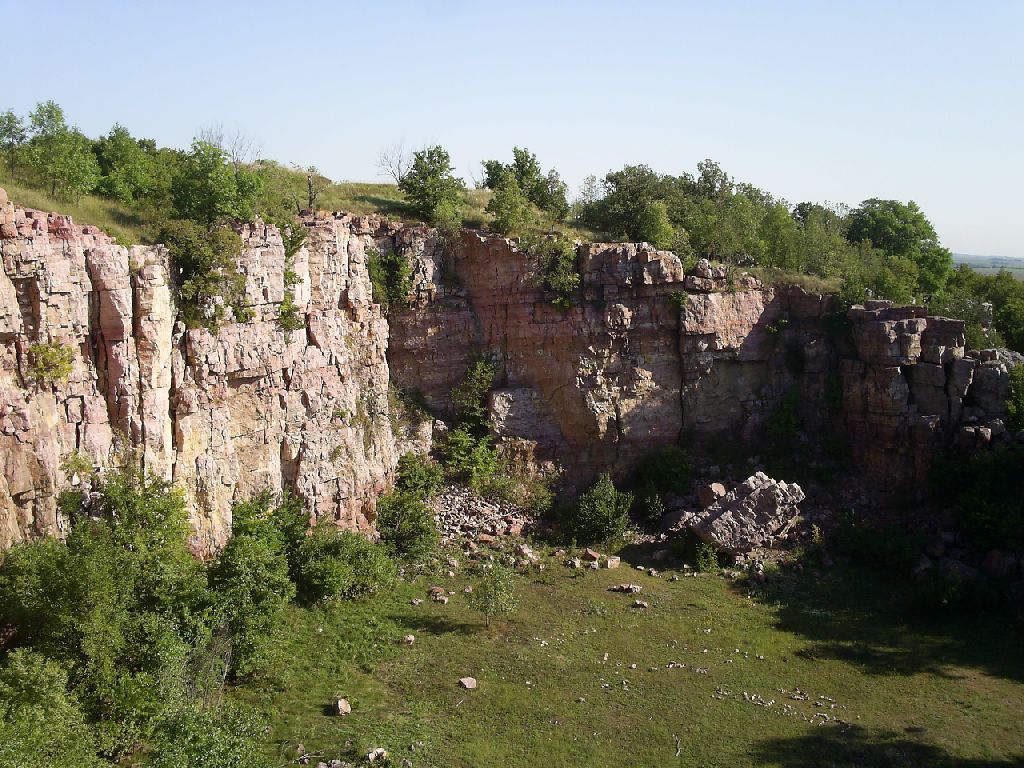
image_caption = Quartzite bedrock in Blue Mounds State Park.
country = United States
country_
state = Minnesota
state_
state_type = State
region_type = County
region = Rock
city_type = City
city = Luverne
lat_d = 43
lat_m = 42
lat_s = 24
lat_NS = N
long_d = 96
long_m = 11
long_s = 13
long_EW = W
area_unit = acre
area_imperial = 1826
area_round = 1
established = 1937
map_locator = Minnesota

management_body =Minnesota Department of Natural Resources Infobox nrhp
name = Blue Mounds State Park WPA/Rustic Style Historic Resources
nrhp_type = hd
caption =
lat_degrees =
lat_minutes =
lat_seconds =
lat_direction =
long_degrees =
long_minutes =
long_seconds =
long_direction =
area =
built =
architect =
architecture =
added =October 25 ,1989
visitation_num =
visitation_year =
refnum = 89001657
mpsub = Minnesota State Park CCC/WPA/Rustic Style MPS
governing_body = Minnesota Department of Natural ResourcesBlue Mounds State Park is a convert|1826|acre|km2|sing=on
Minnesota state park inRock County, Minnesota near the town of Luverne. It protects an American bison herd which grazes on one of the state's largestprairie remnants.The state park is named after a linear
escarpment ofPrecambrian quartzite bedrock , which although pink in color, is said to have appeared blueish in the distance to early settlers. Parts of thecliff are up to 100 feet high. Unusual in the surrounding prairie landscape, they are a popular site forrock climbing .The park also preserves a 1,250 foot (380 m) long line of rocks aligned by
Plains Indians which marks where the sun rises and sets on the spring and fallequinox es. It also has a small reservoir for swimming, the only lake in Rock County. The park's interpretive center was once the home of the authorFrederick Manfred .Four structures and one building in the park, built by the
Works Progress Administration in the 1930s, are listed on theNational Register of Historic Places .The bison herd
The park's bison herd began in 1961 with the purchase of three animals from
Fort Niobrara National Wildlife Refuge inNebraska . Today there are over 100 bison in the park. To keep age and sex ratios close to that of a natural herd, individuals are sold in a fall auction. The bison range is fenced off, and visitors are warned not to approach when these strong and unpredictable animals are near the fenceline.Cultural history
According to local folklore the mound was used as a
buffalo jump before European settlement, but no archaeological evidence has yet been found as verification. The soil of the mound was too thin and boulder-strewn for farming, saving it from the plow, although it was grazed.Parkland was originally established north of the Blue Mound for the purpose of providing work relief during the
Great Depression and water recreation. WPA crews built two dams on Mound Creek, creating Upper and Lower Mound Lake (18 and 28 acres respectively), and facilities such as picnic grounds and a beach house. The convert|195|acre|km2|sing=on Mound Springs Recreational Reserve opened in 1937. In the 1950s trees were planted around the lakes and campground.Land was added in 1955 and 1961, at which point the name was changed to Blue Mounds State Park. More lands were authorized in 1963 and 1965 to include the whole of Blue Mound and property to either side. The state bought Frederick Manfred's house in 1972 to turn into an interpretive center, although they let him live there for three more years. Because the house was at the southern end of the mound and the developed part of the park was at the north end, a connecting road was surveyed across the top. Local conservationists argued the state out of this plan several times in the 1970s, citing the impact to the environment atop the mound. In 1986 a road was paved from the house south to a county highway instead, so that visitors to the interpretive center must hike in from the north or drive around the edge of the park to the south entrance.
Crime scene
Blue Mounds State Park was the scene of a murder
May 20 ,2001 , when Carrie Nelson, then 20, was beaten to death while working alone in the park office. A coroner said the wounds to her head appeared as if she'd been struck with a rock. The killer apparently stole about $2,000 from the park coffers. The case went unsolved for six years until May 2007 when, in a routine check ofDNA samples of prison inmates in South Dakota, police found a match with DNA samples gathered from the crime scene. The samples linked Randy Leeroyal Swaney, 35, to the murder. He was serving time for a 2004 burglary.1External links
* [http://www.dnr.state.mn.us/state_parks/blue_mounds/index.html Blue Mounds State Park website]
Footnotes
*Note 1: "Watch, DNA solved 2001 park slaying", [http://www.startribune.com/462/story/1170428.html Star Tribune] , May 9, 2007, online edition.
References
*Meyer, Roy W. "Everyone's Country Estate: A History of Minnesota's State Parks". Minnesota Historical Society Press: St. Paul, 1991.
*Minnesota Department of Natural Resources. 2006. The Minnesota Department of Natural Resources Web Site (online).
* [http://www.mnhs.org/places/nationalregister/stateparks/Bluemnds.html Rustic Style Resources in Minnesota State Parks: Blue Mounds State Park]

Wikimedia Foundation. 2010.