- Lake Maria State Park
Geobox|Protected area
name = Lake Maria State Park
category =Minnesota State Park
category_iucn = V
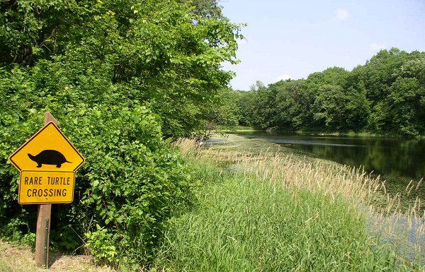
image_caption = Lake Maria State Park features woods, wetlands, and rare turtles.
country = United States
country_
state = Minnesota
state_
state_type = State
region_type = County
region = Wright
city_type = City
city = Monticello
lat_d = 45
lat_m = 18
lat_s = 49
lat_NS = N
long_d = 93
long_m = 57
long_s = 25
long_EW = W
area_unit = acre
area_imperial = 1580
area_round = 1
established = 1963
map_locator = Minnesota

management_body =Minnesota Department of Natural Resources Lake Maria State Park IPA2|mə ˡraɪ ə is a convert|1580|acre|km2|sing=on
Minnesota state park west of Monticello. The park was created in 1963 to provide awilderness area within easy drive ofMinneapolis-St. Paul . The park's amenities are designed primarily for hikers, backpackers, and horseback riders and consequently use remains light compared to other state parks around the metro area.Natural history
The St. Croix
Moraine runs through the park. This rolling and uneven landform is a result of theWisconsin glaciation and two previous glaciations. Irregular hills and ridges (kame s) surround kettles, depressions left by melting blocks of ice during the glaciers' retreat.The park's vegetation is comprised of
Big Woods (maple ,basswood ,elm ) mixed withold-growth oaks and dotted with numerous wetlands, ponds, and small lakes. The park is located near the northern limit of the Big Woods.The forest edge and wetland habitats support deer, foxes, fishers, minks, beavers, and muskrats. 205 bird species have been identified in the park. The park is noted for its population of Blanding's turtles, considered an endangered or threatened species by many
U.S. state s andCanada .Cultural history
The park was first proposed in 1947 in a deal in which the U.S. Forest Service would acquire the land and trade it to the state for state-owned land within
Superior National Forest . The deal fell through because the USFS would not useeminent domain to buy the land from the various current owners. Lake Maria State Park was re-authorized in a 1963 bill that authorized fourteen state parks. Land acquisition through eminent domain began and the park officially opened in 1971. The concept for the park emphasized conservation over recreation, and so hike-in campsites were made in lieu of a drive-in campground. The park was expanded to the north and west in 1980 to include the whole shoreline of Maria Lake. Incidentally the lake originally called Maria Lake was renamed Bjorkland Lake by the DNR, and "Maria Lake" became an arm of Silver Lake, which lies mostly outside the park's western boundary.Recreation
*Boating: Maria Lake has a public boat ramp and some rental canoes. Only outboard motors under convert|20|hp|abbr=on are allowed on the lake.
*Camping:
**17 backpack sites and 3 camper cabins scattered throughout the park, only accessible by a hike of .5 to convert|1|mi|km|sing=on.
**2 primitive group camps accessible by road.
*Fishing: There is a fishing pier on Maria Lake near the picnic area.
*Ice Skating: Seasonal rink near trail center.
*Trails: Many start from the trail center, an all-seasons building featuring interpretive exhibits, indoor picnic benches, and plumbing.
**Anderson Loop Trail (hiking/horseback/skiing): Leads through forest and prairie openings to a view from Anderson Hill (3 mi).
**Bjorkland Lake Trail (hiking/skiing): Loops through forest and meadow to a lake with canoe access (2 mi).
**Kettle and Kame Trail (hiking/skiing): Leads over some of the parks more rugged glacial topography.
**Big Woods Loop (hiking/horseback/skiing): Combines sections of the 3 abovementioned trails for a thorough tour of the park (5.5 mi).
**Zumbrunnen Trail (hiking): An interpretive trail on the shore of Maria Lake with a boardwalk through a wetland.
*Bicycling is confined to the park roads. In winter convert|5|mi|km of road are groomed for skate-skiing.Gallery
External links
* [http://www.dnr.state.mn.us/state_parks/lake_maria/index.html Lake Maria State Park website]
References
*Arthur, Anne. "Minnesota's State Parks". Adventure Publications, Inc.: Cambridge, MN, 1998.
*Bewer, Tim. "Moon Handbooks: Minnesota". Avalon Travel Publishing: Emeryville, CA, 2004.
*Meyer, Roy W. "Everyone's Country Estate: A History of Minnesota's State Parks". Minnesota Historical Society Press: St. Paul, 1991.
*Minnesota Department of Natural Resources. 2006. The Minnesota Department of Natural Resources Web Site (online).

Wikimedia Foundation. 2010.