- Maplewood State Park
-
Coordinates: 46°32′01″N 95°56′57″W / 46.5335703°N 95.9492193°W
Maplewood Site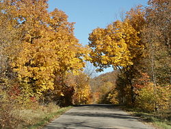 Fall colors at Maplewood State Park
Location: Otter Tail County, Minnesota Nearest city: Pelican Rapids, Minnesota NRHP Reference#: 78001555 Added to NRHP: December 18, 1978 Maplewood State Park is a Minnesota state park near Pelican Rapids. The park preserves a pre-contact habitation site that was occupied in two different periods (650-900 CE and 1450-1650 CE) in a forest/prairie transition zone. Located in the Leaf Mountains, Maplewood encompasses 9,250 acres (36 km²) in Otter Tail County and is known for its hardwood trees including sugar maple, basswood, American elm, and oak, which together provide a stunning display of fall colors each year.
It became a state park in 1965, and due to an archeological site within the park, the Maplewood Site, was listed on the National Register of Historic Places in 1978.
Popular Culture
Jim Fletcher, the author of The Lore Adventure Trilogy, built several small villages with the help of both students of the Pelican Rapids High School, and other local people. Several of these villages are placed in Maplewood State Park. One is accessible by a hiking trail, while another is located inside one of the lakes. Those are two of the known locations, while there may be many others inside of Maplewood.
Jim Fletcher also is an artist, and he was chosen to paint a mural onto one of the walls in Pelican Rapids High School. The artist told a friend that the mural was a hint to where one of his villages was hidden. The mural is not visible to the public, for that part of the school is dangerous.
References
- Nord, Mary Ann (2003). The National Register of Historic Places in Minnesota: A Guide. St. Paul, Minnesota: Minnesota Historical Society Press.
- "Maplewood State Park, Otter Tail County, MN". http://www.co.otter-tail.mn.us/maplewood/.
- "The Lore Adventure". http://www.loreadventure.com/navigate.htm.
External links
U.S. National Register of Historic Places Topics Lists by states Alabama • Alaska • Arizona • Arkansas • California • Colorado • Connecticut • Delaware • Florida • Georgia • Hawaii • Idaho • Illinois • Indiana • Iowa • Kansas • Kentucky • Louisiana • Maine • Maryland • Massachusetts • Michigan • Minnesota • Mississippi • Missouri • Montana • Nebraska • Nevada • New Hampshire • New Jersey • New Mexico • New York • North Carolina • North Dakota • Ohio • Oklahoma • Oregon • Pennsylvania • Rhode Island • South Carolina • South Dakota • Tennessee • Texas • Utah • Vermont • Virginia • Washington • West Virginia • Wisconsin • WyomingLists by territories Lists by associated states Other  Category:National Register of Historic Places •
  Portal:National Register of Historic PlacesCategories:
- Minnesota state parks
- National Register of Historic Places in Minnesota
- Protected areas of Otter Tail County, Minnesota
- Minnesota Registered Historic Place stubs

Wikimedia Foundation. 2010.