- Craighill Channel Lower Range Front Light
-
Craighill Channel Lower Range Front Light 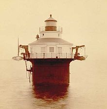
22 August 1885 photo by Major Jared A. Smith. Location Entrance to the Patapsco River, Chesapeake Bay, Maryland Coordinates 39°11′19″N 76°23′40″W / 39.1886°N 76.3945°WCoordinates: 39°11′19″N 76°23′40″W / 39.1886°N 76.3945°W Year first lit 1873 (temporary lights), completed 1875 Automated 1964 Foundation caisson with circular dwelling / tower. Tower shape Cylindrical Height 9 feet (main light), 22 feet – range. Range 16 miles Characteristic Fixed white for both range lights, The front light also has a flashing white main light with one red sector. The Craighill Channel Lower Range Front Light, named for William Price Craighill, was the first caisson lighthouse built in the Chesapeake Bay in Maryland. First lit in 1873, the range marks the first leg of the maintained Craighill Channel from the Chesapeake Bay at the mouth of the Patapsco River into the Baltimore harbor and works in conjunction with the Craighill Channel Lower Range Rear Light. It has been owned by non-profit organization Historical Place Preservation, Inc. since 2005.
History
This light was constructed in 1873 and is considered a greater feat of engineering than its predecessor, the Duxbury Light (the first caisson lighthouse, built in 1872), as it was built in deeper water under more difficult conditions. The caisson type quickly became the preferred type of lighthouse to be built in climates where ice floe damage was a possibility. The front range light is unusual for having two lights and is the only surviving example in the Chesapeake Bay. A beacon light is fixed above the gallery deck which serves as the front light for the range and a light in the lantern serves as a general aid to navigation.
The station has never suffered ice damage despite it being located in a very exposed position; however the station was once abandoned and the light extinguished on February 11, 1936, because of dangerous ice conditions. It was not relit till February 24. In 1899 the station received "new model fifth-order lamps." A fog bell operated by gas was established at the station in 1923. The light was changed from oil to electric on November 26, 1929. The fog signal was changed to an air whistle on October 24, 1932. In 1938 the light was described as having a Reynolds flasher to produce the one-second flash with two-second eclipse. A spare fourth-order "wick lamp" was kept as a backup. Oil was stored in a 225-gallon tank kept in the cellar. The fog signal was a number 4 Typhone Horn with an eight-inch-diameter whistle, which gave a three-second blast every 27 seconds. A backup Gamewell weight-driven clock mechanism produced a double strike every 30 seconds. The weight had to be rewound every hour and a half. The fog bell was a standard 1000-pound bell.
Water was collected from the roof and stored in two steel 500-gallon tanks. The station had a 18-foot (5.5 m) "motor boat" and a 16-foot (4.9 m) "skiff" hung from davits. There was a keeper and an assistant until the station was automated on May 5, 1964.
In November 2005, ownership of the lighthouse was transferred to the nonprofit organization Historical Place Preservation, Inc. under the National Historic Lighthouse Preservation Act of 2000 (NHLPA). HPP plans to restore the lighthouse and open it to the public.
Currently, the lighthouse is in disrepair, but is a popular sailing destination for people in the Baltimore area. It is rusted and deteriorating, but still has an automated flashing beacon.
References
- "Historic Light Station Information and Photography: Maryland". United States Coast Guard Historian's Office. http://www.uscg.mil/history/weblighthouses/LHMD.asp.
- Craighill Range Lighthouses, from the Chesapeake Chapter of the United States Lighthouse Society.
- History of Craighill Channel Lower Front Light
External links
- http://www.craighillrange.org
- Rowlett, Russ. "Lighthouses of the United States: Maryland". The Lighthouse Directory. University of North Carolina at Chapel Hill. http://www.unc.edu/~rowlett/lighthouse/md.htm.
- Chesapeake Bay Lighthouse Project - Craighill Channel Range Lights
Craighill Channel (lower) Baltimore Light • Front Range Light • Rear Range LightUpper Craighill Channel (cutoff) Brewerton Channel Hawkins Point Light (front range) • Leading Point Light (rear range)U.S. National Register of Historic Places in Maryland Lists by county Allegany • Anne Arundel • Baltimore County • Calvert • Caroline • Carroll • Cecil • Charles • Dorchester • Frederick • Garrett • Harford • Howard • Kent • Montgomery • Prince George's • Queen Anne's • Somerset • St. Mary's • Talbot • Washington • Wicomico • Worcester

Lists by city Other lists Keeper of the Register • History of the National Register of Historic Places • Property types • Historic district • Contributing property Categories:- Lighthouses on the National Register of Historic Places in Maryland
- Lighthouses in Maryland
- Buildings and structures completed in 1875


Wikimedia Foundation. 2010.