Upper Cedar Point Light

Upper Cedar Point Light

Infobox Lighthouse


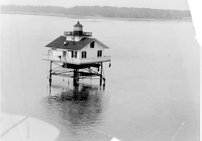
caption = Upper Cedar Point Light, seen from the air during the 1920s
location = 2 miles West of Matthias Point in the Potomac River
coordinates = coord|38.4027|N|77.0826|W|type:landmark
yearlit = 1867
automated =
yeardeactivated = 1963
foundation = screw-pile
construction = cast-iron/wood
shape = square house
The Upper Cedar Point Light was a screw-pile lighthouse in the Potomac River in Maryland. It was first lit in 1867 and served, except for a brief period of inactivity, until being dismantled in 1963.

History

The station had been served by a lightvessel since 1821. In 1867 a small square screw-pile structure was constructed at the site. It served until 1876, when the Mathias Point Light was constructed to the east. The Lighthouse Board received numerous complaints, however, and reactivated the light in 1882. It remained active until 1963, when it was dismantled and replaced with a small automatic tower mounted on the original foundation.

Upper Cedar Point Light was tended by a black keeper and assistant keeper for a time in the 1870s, one of the few American lighthouses to be so served.

References

* [http://www.cheslights.org/heritage/upcedarpt.htm Chesapeake Chapter, USLHS page]
*cite book
last= de Gast
first= Robert
title= The Lighthouses of the Chesapeake
year= 1973
publisher= Johns Hopkins University Press
p. 158


Wikimedia Foundation. 2010.

Игры ⚽ Нужно решить контрольную?

Look at other dictionaries:

  • Cedar Point Light — Infobox Lighthouse caption = location = Cedar Point at the mouth of the Patuxent River coordinates = coord|38.2992|N|76.3860|W|type:landmark yearlit = 1896 automated = yeardeactivated = 1920 foundation = construction = brick shape = House with… …   Wikipedia

  • Cedar Point (disambiguation) — Cedar Point is a major amusement park in Sandusky, Ohio, in the United States.Cedar Point may also refer to:;United States *Cedar Point, Illinois *Cedar Point, Indiana *Cedar Point, Kansas *Cedar Point, North Carolina *Cedar Point County Park,… …   Wikipedia

  • Craighill Channel Upper Range Front Light — undated photograph of the Craighill Channel Upper Range Front Light (USCG) Location West of Fort Howard (North Point) on the north shore of the Patapsco River Coordinates …   Wikipedia

  • Craighill Channel Upper Range Rear Light — Location East side of Sparrows Point on the north shore of the Patapsco River Coordinates …   Wikipedia

  • Mathias Point Light — Location Potomac River opposite the mouth of the Port Tobacco River Coordinates 38°24′18″N 77°02′34″W /  …   Wikipedia

  • Cove Point Light — 1961 photograph of Cove Point Light (USCG) Location on Cove Point just south of Calvert Cliffs State Park Coordinates …   Wikipedia

  • Drum Point Light — 1915 photograph of Drum Point Light (USCG) Location originally off Drum Point at the mouth of the Patuxent River in the Chesapeake Bay; relocated to the Calvert Marine Museum Coordinates …   Wikipedia

  • Concord Point Light — Location Havre de Grace, Maryland Coordinates …   Wikipedia

  • Maryland Point Light — 1952 photograph of Maryland Point Light (USCG) Location off Maryland Point in the Potomac River, East of Fairview Beach, Virginia Coordinates …   Wikipedia

  • Old Field Point Light — Old Field Point Lighthouse Old Field Point Light Location Old Field, New York, Long Island north shore Coordinates …   Wikipedia

Share the article and excerpts

Direct link
Do a right-click on the link above
and select “Copy Link”