- Mathias Point Light
-
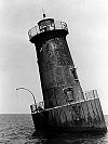
Mathias Point Light Location Potomac River opposite the mouth of the Port Tobacco River Coordinates 38°24′18″N 77°02′34″W / 38.4051°N 77.0428°WCoordinates: 38°24′18″N 77°02′34″W / 38.4051°N 77.0428°W Year first lit 1876 Automated 1951 Deactivated 1961 Foundation screw-pile Construction cast-iron/wood Tower shape hexagonal house Original lens fifth-order Fresnel lens The Mathias Point Light was a screw-pile lighthouse in the Potomac River in Maryland; the station was located near the Port Tobacco River. It was particularly noted for its ornate woodwork.
History
Funds for a light near Quantico, Virginia were appropriated in 1872. An engineering study recommended instead that lights be built 24 miles (39 km) downstream, and an appropriation was made in 1874 to build a light on Port Tobacco Flats, with a day beacon for Matthias Point. By the time construction began the two were switched, and the light was completed in 1876. Matthias Point was like no other screw-pile structure on the bay, with much decorative woodwork and a distinctive three tiered structure that some described as resembling a wedding cake.
It was intended that this light replace that at Upper Cedar Point; in the end the number of complaints led to the latter's reactivation in 1882. Matthias Point Light itself was automated in 1951 and replaced in 1961 by a beacon mounted on the old foundation.
References
- Mathias Point Shoal Light Chesapeake Chapter, USLHS page
- "Historic Light Station Information and Photography: Maryland". United States Coast Guard Historian's Office. http://www.uscg.mil/history/weblighthouses/LHMD.asp.
- de Gast, Robert (1973). The Lighthouses of the Chesapeake. Johns Hopkins University Press. p. 157.
External links
- Rowlett, Russ. "Lighthouses of the United States: Maryland". The Lighthouse Directory. University of North Carolina at Chapel Hill. http://www.unc.edu/~rowlett/lighthouse/md.htm.
 Categories:
- Lighthouses in Maryland
- Buildings and structures completed in 1876

Wikimedia Foundation. 2010.