- Sharps Island Light
Infobox Lighthouse
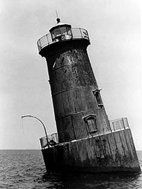
caption = NPS photo by Candace Clifford, 1997
location = SW ofTilghman Island ,Chesapeake Bay ,Maryland
coordinates = coord|38.6391|N|76.3757|W|type:landmark
yearlit = 1838 (original), 1866 (second), 1882 (current)
automated = 1938
yeardeactivated =
foundation = Concrete Caisson
construction = Cast Iron
shape = Conical
height = 35 feet (10.7 m)
lens = Fourth Order Fresnel (250 mm since 1977)
range =
characteristic =
builder =
status = activeThe Sharps Island Light is the third
lighthouse to stand nearly 3mile s (5 km) south-southwest from the southern end ofTilghman Island inMaryland 'sChesapeake Bay . [cite web| url=http://www.lighthousefriends.com/light.asp?ID=430| title=Sharps Island Light| author=Kraig Anderson| accessdate=January 11| accessyear=2007| ] The structure is best known today for evoking theLeaning Tower of Pisa , a condition caused by anice floe in 1977.The first lighthouse was built on Sharps Island in 1838, but due to the island's erosion it was moved in 1848. This was replaced with a
screwpile lighthouse in 1866 near the original location of the first structure. [cite web| url=http://www.cr.nps.gov/maritime/light/sharps.htm| title=Inventory of Historic Light Stations: Sharps Island Light| author=National Park Service | accessdate=January 11| accessyear=2007| ] The second lighthouse lasted until 1881 when it was forced off its foundations by an ice floe. It floated nearly five miles down the Chesapeake — with its keepers still inside — until it ran aground, allowing the men to escape unharmed. [cite web| url=http://www.cheslights.org/heritage/sharps.htm| title=Sharps Island Lighthouse| author=Chesapeake Chapter:United States Lighthouse Society | accessdate=January 11| accessyear=2007| ]The current light was constructed in 1882 with a concrete caisson foundation and a 35-foot (10.7-m)
cast iron tower. The fourth orderFresnel lens was replaced with a 250 mm lens in 1977; the focal plane is 54 feet (16.5 m) above sea level. The tower includes an integral dwelling and was manned until 1938 when theUnited States Coast Guard automated the light. [cite web| url=http://www.cr.nps.gov/maritime/light/sharps.htm| title=Inventory of Historic Light Stations: Sharps Island Light| author=National Park Service | accessdate=January 11| accessyear=2007| ] Leaning by about 15° since it was ice-damaged in 1977, the structure is picturesque, but in poor condition.The Sharps Island Light was listed on the
National Register of Historic Places onJuly 22 1982 . It is one of the many historic features alongCaptain John Smith Chesapeake National Historic Trail .References
Wikimedia Foundation. 2010.