- Seven Foot Knoll Light
Infobox Lighthouse
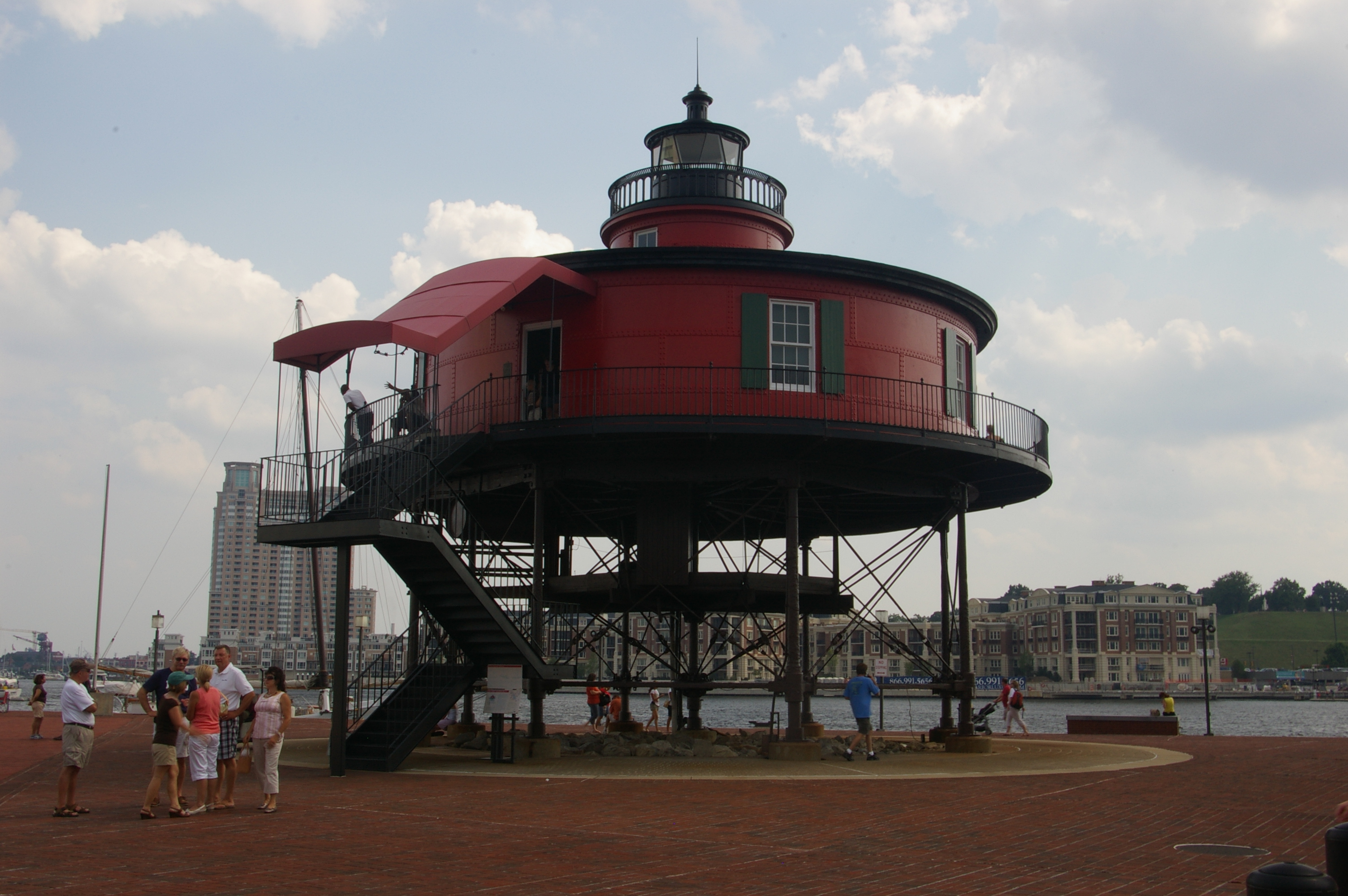
caption = Seven Foot Knoll Lighthouse at its present location
location = originally at the mouth of thePatapsco River in theChesapeake Bay ; relocated to theInner Harbor inBaltimore, Maryland
coordinates = coord|39.1551|N|76.4091|W|type:landmark (original);
coord|39.2836|N|76.6054|W|type:landmark (current)
yearlit = 1855
automated = 1949
yeardeactivated = 1988
foundation = screw-pile
construction =wrought-iron (originallycast-iron )
shape = cylindrical house (originally octagonal)
height = convert|40|ft|m|abbr=on
lens = fourth-orderFresnel lens
currentlens =
range = convert|12|mi|km|abbr=on
status = moved to museumThe Seven Foot Knoll Light was built in 1855 and is the oldestscrew-pile lighthouse inMaryland . It was initially installed on a shallowshoal , Seven Foot Knoll, at the mouth of thePatapsco River . The northern reach of this river is the Baltimore Harbor, where the now-decommissioned lighthouse has been placed as a museum.Constructed of 1-inch (25 mm) rolled
iron , the lighthouse consists of three main sections. The gallery deck was located 9 feet (2.7 m) above the average high tide waters. The house was the second section, sitting directly atop the gallery deck. This is where the keeper and his family would live. Atop the housing area was the third section of the lighthouse, the light beacon. A 4th orderFresnel lens was housed in the small light compartment. It was visible for 12 miles (19 km).The first requests for a light came in 1848, with initial appropriations in 1851. Delays in planning and bidding pushed the start of construction to 1854. Total construction costs came to $43,000 by its completion the following year. Most parts were prefabricated in
Baltimore at the Murray and Hazelhurst ironfoundry . The parts were then shipped to Seven Foot Knoll by boat where they were assembled atop of the screw piles. In 1875 the original house was replaced with the current cylindrical structure made of wrought iron plates. Ice, the perennial threat to screw-pile structures, caused damage in 1884 and 1894, leading to the piling of convert|790|cuyd|m3 ofriprap around the piles.A light-keeper and his family would have stayed on the lighthouse year-round with 8 days off per month. Probably the most famous of the lighthouse keepers was also the last one, Thomas Jefferson Steinhice (also spelled Steinhise and Steinheiss on various family documents). Steinhice, who was tending the lighthouse with his son Earl, rescued 5 men from their tugboat which had broken down on
August 21 ,1933 . The 90 mph (145 km/h) winds and 15-foot (5 m) seas had rendered the tug inoperable. Steinhice took the lighthouse's small motorboat and made his way out in the direction of the tug's distress whistle. He was awarded the Silver Lifesaving Medal for his actions in saving the lives of the stranded crew.The light was automated in 1949, and fell into disrepair, eventually being supplanted by the usual skeleton tower. In 1988, the lighthouse was removed from Seven Foot Knoll, carried by barge, and placed ashore in
Baltimore 'sInner Harbor where it was donated to the city. OnAugust 22 ,1989 the lighthouse was listed on theNational Register of Historic Places . Aided by the Lady Maryland Foundation, many members of the Steinhice family descendants worked to restore the structure prior to its re-opening.In 1997 the lighthouse was transferred to the
Baltimore Maritime Museum where it is located today.References
* [http://www.baltomaritimemuseum.org/lh/sevenfootknoll.html Official webpage at Baltimore Maritime Museum]
* [http://www.uscg.mil/history/weblighthouses/LHMD.asp Maryland Light Stations] , from theUnited States Coast Guard
* [http://www.cheslights.org/heritage/seven-foot.htm Seven Foot Knoll Lighthouse] , from the Chesapeake Chapter of theUnited States Lighthouse Society
* [http://www.lighthousefriends.com/light.asp?ID=419 Seven Foot Knoll Lighthouse] at lighthousefriends.com
Wikimedia Foundation. 2010.