- National Register of Historic Places listings in Talbot County, Maryland
-
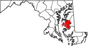
 Location of Talbot County in Maryland
This is a list of the National Register of Historic Places listings in Talbot County, Maryland.
This is intended to be a complete list of the properties and districts on the National Register of Historic Places in Talbot County, Maryland, United States. Latitude and longitude coordinates are provided for many National Register properties and districts; these locations may be seen together in a Google map.[1]
There are 61 properties and districts listed on the National Register in the county, including 5 National Historic Landmarks.
Contents: Counties in Maryland Allegany - Anne Arundel - Baltimore (city) - Baltimore County - Calvert - Caroline - Carroll - Cecil - Charles - Dorchester - Frederick - Garrett - Harford - Howard - Kent - Montgomery - Prince George's - Queen Anne's - Somerset - St. Mary's - Talbot - Washington - Wicomico - Worcester -
- This National Park Service list is complete through NPS recent listings posted November 10, 2011.[2]
Current listings
[3] Landmark name[4] Image Date listed Location City or Town Summary 1 All Saints' Church May 27, 1983 Maryland Route 662
38°50′46″N 76°4′53″W / 38.84611°N 76.08139°WEaston 2 The Anchorage July 30, 1974 Northwest of Easton off Maryland Route 370
38°47′41″N 76°7′49″W / 38.79472°N 76.13028°WEaston 3 Barnaby House November 24, 1992 212 N. Morris St.
38°41′26″N 76°10′26″W / 38.69056°N 76.17389°WOxford 4 BILLIE P. HALL (log canoe) September 18, 1985 Evergreen Rd.
38°40′27″N 76°8′25″W / 38.67417°N 76.14028°WOxford 5 Cannonball House 
December 3, 1980 200 Mulberry St.
38°47′3″N 76°13′22″W / 38.78417°N 76.22278°WSt. Michaels 6 CLAUDE W. SOMERS May 16, 1985 Old Ferry Terminal, Washington St.
38°50′11″N 76°16′51″W / 38.83639°N 76.28083°WClaiborne 7 Clay's Hope October 31, 1979 Bellevue Rd.
38°42′25″N 76°11′17″W / 38.70694°N 76.18806°WBellevue 8 Compton July 25, 1974 Wets of Trappe on Howell Point Rd.
38°38′27″N 76°6′25″W / 38.64083°N 76.10694°WTrappe 9 Crooked Intention July 24, 1974 West of Maryland Route 33
38°46′44″N 76°13′53″W / 38.77889°N 76.23139°WSt. Michaels 10 Doncaster Town Site September 5, 1975 Buffs Island Rd., on the shores of Shaw Bay
38°51′30″N 76°11′27″W / 38.85833°N 76.19083°W[5]Easton 11 E.C. COLLIER 
May 16, 1985 Gibsontown Rd.
38°42′46″N 76°19′53″W / 38.71278°N 76.33139°WTilghman 12 Easton Historic District September 17, 1980 Maryland Routes 328, 331, and 565
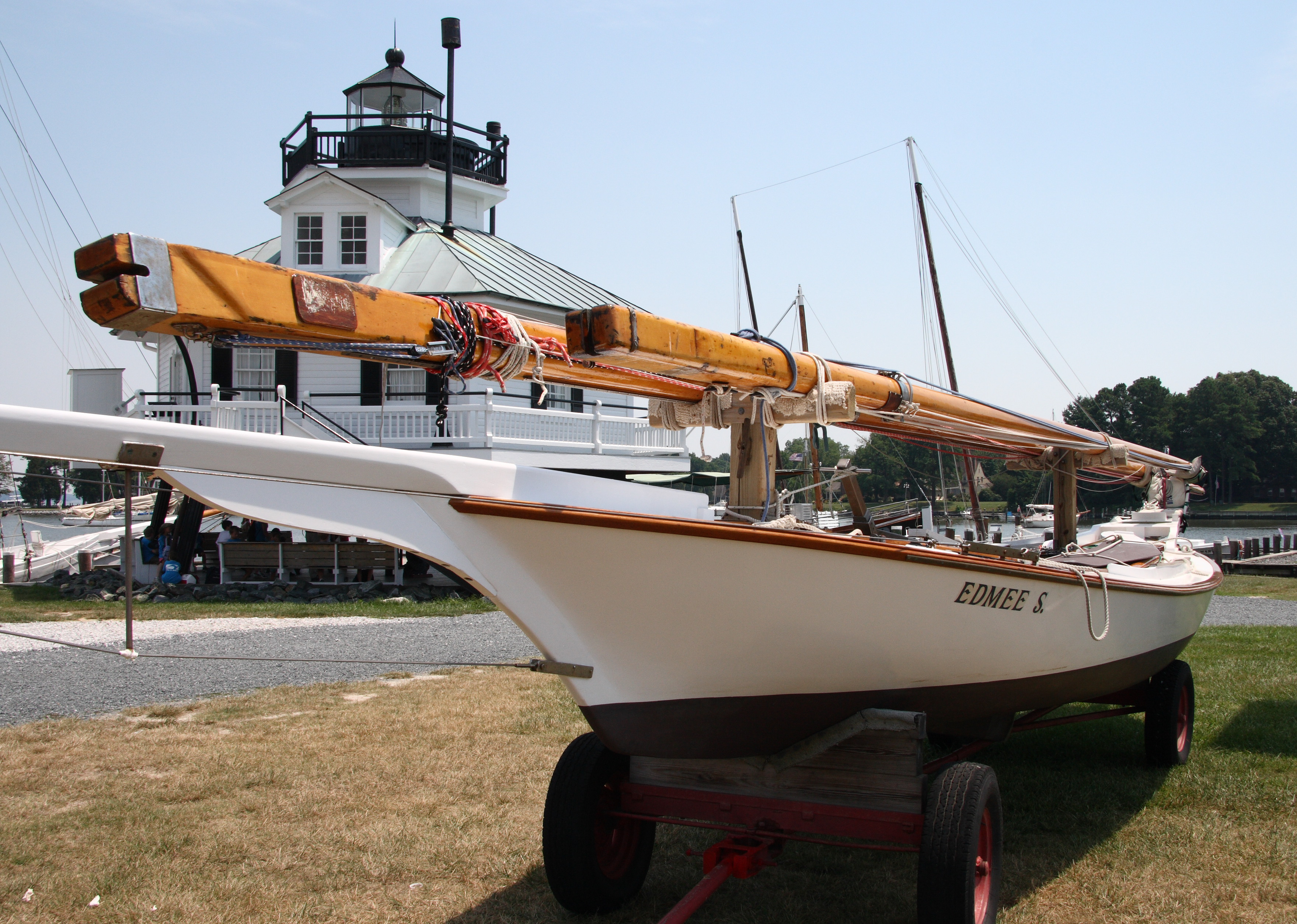
38°46′19″N 76°4′26″W / 38.77194°N 76.07389°WEaston 13 EDMEE S. (log canoe) 
September 18, 1985 Mill St.
38°47′15″N 76°13′9″W / 38.7875°N 76.21917°WSt. Michaels 14 EDNA E. LOCKWOOD (Chesapeake Bay bugeye) 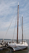
February 13, 1986 Navy Point at the foot of Mill St.
38°47′15″N 76°13′10″W / 38.7875°N 76.21944°WSt. Michaels 15 FLYING CLOUD (log canoe) September 18, 1985 Magee Rd.
38°46′48″N 76°17′23″W / 38.78°N 76.28972°WWittman 16 HILDA M. WILLING May 16, 1985 Gibsontown Rd.
38°42′46″N 76°19′53″W / 38.71278°N 76.33139°WTilghman 17 Hope House November 1, 1979 Northwest of Easton, northeast of Voit Rd., and 0.8 miles northwest of the bridge at Tunis Mill
38°50′1″N 76°11′10″W / 38.83361°N 76.18611°WEaston 18 ISLAND BIRD (log canoe) September 18, 1985 Miles River Yacht Club
38°48′0″N 76°13′10″W / 38.8°N 76.21944°WSt. Michaels 19 ISLAND BLOSSOM (log canoe) September 18, 1985 Miles River Yacht Club
38°48′0″N 76°13′10″W / 38.8°N 76.21944°WSt. Michaels 20 ISLAND LARK (log canoe) September 18, 1985 Carpenter St.
38°47′10″N 76°13′19″W / 38.78611°N 76.22194°WSt. Michaels 21 JAY DEE (log canoe) September 18, 1985 Miles River Yacht Club
38°48′0″N 76°13′10″W / 38.8°N 76.21944°WSt. Michaels 22 Jena August 6, 1980 East of Oxford off Maryland Route 333
38°41′17″N 76°8′18″W / 38.68806°N 76.13833°WOxford 23 KATHRYN 
May 16, 1985, designated NHL April 19, 1994 Dogwood Harbor
38°42′46″N 76°19′53″W / 38.71278°N 76.33139°WTilghman Island Listed twice in the NRIS: once simply as "KATHRYN", the other as "KATHRYN (Chesapeake Skipjack)" 24 Llandaff House December 27, 2002 28472 Old Country Club Rd.
38°43′58″N 76°5′22″W / 38.73278°N 76.08944°WEaston 25 MAGGIE LEE May 16, 1985 Gibsontown Rd.
38°42′46″N 76°19′53″W / 38.71278°N 76.33139°WTilghman 26 MAGIC (log canoe) September 18, 1985 St. Michaels Marina
38°47′6″N 76°13′13″W / 38.785°N 76.22028°WSt. Michaels 27 Miller's House December 17, 2010 Old Wye Mills Rd.
38°54′57″N 76°4′33″W / 38.91583°N 76.07583°WWye Mills vicinity 28 MINNIE V May 16, 1985 Gibsontown Rd.
38°42′46″N 76°19′53″W / 38.71278°N 76.33139°WTilghman 29 Myrtle Grove August 13, 1974 Goldsborough Neck Rd.
38°48′15″N 76°7′6″W / 38.80417°N 76.11833°WEaston 30 NELLIE L. BYRD May 16, 1985 Gibsontown Rd.
38°42′46″N 76°19′53″W / 38.71278°N 76.33139°WTilghman 31 NODDY (log canoe) September 18, 1985 Deepwater Point Rd.
38°48′5″N 76°13′17″W / 38.80139°N 76.22139°WSt. Michaels 32 Old Bloomfield December 3, 1980 West of Easton on Bloomfield Rd.
38°45′59″N 76°7′6″W / 38.76639°N 76.11833°WEaston 33 The Old Inn 
March 25, 1980 Talbot and Mulberry Sts.
38°47′1″N 76°13′25″W / 38.78361°N 76.22361°WSt. Michaels 34 Old Wye Church August 9, 1984 Queenstown-Easton Rd.
38°56′11″N 76°4′48″W / 38.93639°N 76.08°WWye Mills 35 Orem's Delight April 4, 1978 South of Bellevue off Ferry Neck Rd., on Benoni Point Rd.
38°41′10″N 76°12′11″W / 38.68611°N 76.20306°WBellevue 36 Otwell March 15, 1982 Otwell Rd.
38°41′55″N 76°8′16″W / 38.69861°N 76.13778°WOxford 37 Oxford Historic District December 28, 2005 Roughly bounded by Tred Avon Rd., Town Creek, and Caroline Ave.
38°41′33″N 76°10′18″W / 38.6925°N 76.17167°WOxford 38 Paw Paw Cove Site 
December 23, 2009 Address Restricted Tilghman 39 PERSISTENCE (log canoe) September 18, 1985 St. Michaels Marina
38°47′6″N 76°13′13″W / 38.785°N 76.22028°WSt. Michaels 40 RALPH T. WEBSTER May 16, 1985 Gibsontown Rd.
38°42′46″N 76°19′53″W / 38.71278°N 76.33139°WTilghman 41 REBECCA T. RUARK 
May 16, 1985 Gibsontown Rd.
38°42′46″N 76°19′53″W / 38.71278°N 76.33139°WTilghman 42 RELIANCE (Chesapeake Bay skipjack) July 30, 1976 Knapps Narrows off Maryland Route 33
38°42′46″N 76°20′7″W / 38.71278°N 76.33528°WTilghman 43 Rock Clift July 30, 1980 Southeast of Matthews off Maryland Route 328
38°48′12″N 75°56′37″W / 38.80333°N 75.94361°WMatthews 44 ROVER (log canoe) September 18, 1985 St. Michaels Marina
38°47′6″N 76°13′13″W / 38.785°N 76.22028°WSt. Michaels 45 RUBY G. FORD May 16, 1985 Gibsontown Rd.
38°42′46″N 76°19′53″W / 38.71278°N 76.33139°WTilghman 46 S.C. DOBSON (log canoe) September 18, 1985 Peach Blossom Rd.
38°41′34″N 76°9′33″W / 38.69278°N 76.15917°WOxford 47 Saint Michaels Mill 
July 15, 1982 100 Chew Ave.
38°46′56″N 76°13′13″W / 38.78222°N 76.22028°WSt. Michaels 48 SANDY (log canoe) September 18, 1985 Sherwood Rd.
38°45′40″N 76°19′9″W / 38.76111°N 76.31917°WSherwood 49 Sharps Island Light 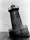
July 22, 1982 Southwest of Tilghman Island
38°38′19″N 76°22′5″W / 38.63861°N 76.36806°WTilghman Island 50 Sherwood Manor April 5, 1977 4 miles north of St. Michaels on Maryland Route 451
38°50′0″N 76°15′42″W / 38.833333°N 76.26167°WSt. Michaels 51 SIGSBEE May 16, 1985 Knapps Narrows
38°43′9″N 76°20′2″W / 38.71917°N 76.33389°WTilghman 52 St. John's Chapel of St. Michael's Parish March 30, 1973 3 miles west of Easton on Maryland Route 370
38°47′46″N 76°7′43″W / 38.79611°N 76.12861°WEaston 53 St. Michaels Historic District 
September 11, 1986 Roughly bounded by North Ave., Mill St., the Miles River, Seymour, Baltimore and Eastern Railroad tracks, and Glory Ave.
38°47′4″N 76°13′24″W / 38.78444°N 76.22333°WSt. Michaels 54 STANLEY NORMAN May 16, 1985 Edgar Cove
38°45′58″N 76°15′37″W / 38.76611°N 76.26028°WSt. Michaels 55 Tidewater Inn November 2, 2007 101 E. Dover St.
38°46′28″N 76°4′29″W / 38.77444°N 76.07472°WEaston 56 Troth's Fortune April 24, 1975 3.25 miles east of Easton on Maryland Route 331
38°45′49″N 75°59′41″W / 38.76361°N 75.99472°WEaston 57 Victorian Corn Cribs January 11, 1976 6.8 miles east of St. Michaels off Maryland Route 33
38°47′10″N 76°8′11″W / 38.78611°N 76.13639°WSt. Michaels 58 VIRGINIA W May 16, 1985 Knapps Narrows
38°43′9″N 76°20′2″W / 38.71917°N 76.33389°WTilghman 59 The Wilderness July 25, 1974 Southwest of Trappe on Island Neck Rd.
38°38′22″N 76°8′12″W / 38.63944°N 76.13667°WTrappe 60 Wye House 
April 15, 1970 7 miles northwest of Easton on the Miles Neck River
38°51′2″N 76°10′14″W / 38.85056°N 76.17056°WEaston 61 Wye Town Farm House December 16, 1982 Northwest of Easton on Bruff's Island Rd.
38°50′31″N 76°11′18″W / 38.84194°N 76.18833°WEaston See also
- List of National Historic Landmarks in Maryland
- National Register of Historic Places listings in Maryland
References
- ^ The latitude and longitude information provided in this table was derived originally from the National Register Information System, which has been found to be fairly accurate for about 99% of listings. For about 1% of NRIS original coordinates, experience has shown that one or both coordinates are typos or otherwise extremely far off; some corrections may have been made. A more subtle problem causes many locations to be off by up to 150 yards, depending on location in the country: most NRIS coordinates were derived from tracing out latitude and longitudes off of USGS topographical quadrant maps created under North American Datum of 1927, which differs from the current, highly accurate GPS system used by Google maps. Chicago is about right, but NRIS longitudes in Washington are higher by about 4.5 seconds, and are lower by about 2.0 seconds in Maine. Latitudes differ by about 1.0 second in Florida. Some locations in this table may have been corrected to current GPS standards.
- ^ "National Register of Historic Places: Weekly List Actions". National Park Service, United States Department of the Interior. Retrieved on November 10, 2011.
- ^ Numbers represent an ordering by significant words. Various colorings, defined here, differentiate National Historic Landmark sites and National Register of Historic Places Districts from other NRHP buildings, structures, sites or objects.
- ^ "National Register Information System". National Register of Historic Places. National Park Service. 2008-04-24. http://nrhp.focus.nps.gov/natreg/docs/All_Data.html.
- ^ Location derived from its http://geonames.usgs.gov/pls/gnispublic/f?p=gnispq:3:::NO::P3_FID:592719 GNIS feature record]; the NRIS lists the site as "Address Restricted".
U.S. National Register of Historic Places in Maryland Lists by county Allegany • Anne Arundel • Baltimore County • Calvert • Caroline • Carroll • Cecil • Charles • Dorchester • Frederick • Garrett • Harford • Howard • Kent • Montgomery • Prince George's • Queen Anne's • Somerset • St. Mary's • Talbot • Washington • Wicomico • Worcester

Lists by city Other lists Keeper of the Register • History of the National Register of Historic Places • Property types • Historic district • Contributing property Municipalities and communities of Talbot County, Maryland County seat: Easton Towns Easton | Oxford | Queen Anne‡ | Saint Michaels | Trappe
CDPs Other
communitiesFootnotes ‡This populated place also has portions in an adjacent county or counties
Categories:- National Register of Historic Places in Maryland by county
- Talbot County, Maryland
-


Wikimedia Foundation. 2010.